

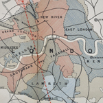
‘Topographical [and Geological] Map of London and its Environs’ by Robert William Mylne, (1851). GSL Library collection. This is the first geological map of London. Its author, Robert William Mylne, FGS (1817-1890), had a successful consulting practice specialising in constructing water supply structures such as wells, reservoirs and drainage. It is likely much of the research derived from his work as a water engineer in the city.
Up until 1852, when the first of the Metropolis Water Acts came into force, there were no minimum standards of any kind for the supply of water to London’s inhabitants. Most of London’s water supply came entirely untreated from various parts of the Thames which also acted as the primary outlet for the city’s sewage and industrial effluence. As a consequence there were multiple outbreaks of waterborne diseases such as cholera among the populace.
This exhibition focuses on the early years of water legislation for London and how the search for a clean water supply led to the formation of the study of hydrogeology in Britain.
Click on the links below to find out more:
 |
 |
 |
| Water Monopoly | 1828 Royal Commission | The Blue Plague |
 |
 |
 |
| Artesian Wells | Strata under London | 1852 Metropolis Water Act |