William Smith
|
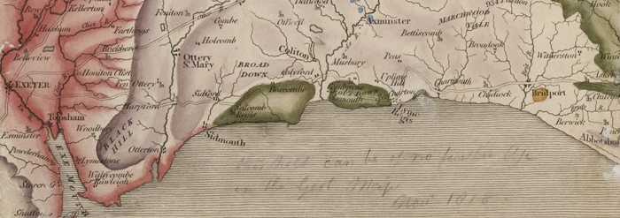
| Detail from Greenough's personal copy of William Smith's map 'A Delineation of the Strata of England & Wales...' (1815) with an annotation in his hand "this sheet can be of no further use to the Geol Map Nov 1818." Greenough collection, ref: LDGSL/947/6/B/4. |

|
| William Smith. Ref: GSL/POR/15 |
The civil engineer
William Smith (1769-1839) had of course been working on his own geological map of England and Wales from at least 1801. Initially a small map was to appear as part of a proposed book
'Accurate Delineations and Descriptions of the Natural order of the Various Strata that are found in the Different Parts of England and Wales with Practical Observations Thereon' to be issued in 1802, but his publisher John Debrett went bankrupt twice so the work never appeared.
By 1804 Smith was promoting subscriptions for a larger, more ambitious map but progress had stalled by the time members of the Society, who included Greenough amongst its number, paid him a visit in Spring 1808. Smith had been focusing on earning a living as an itinerant engineer and surveyor but in 1812 this was to change when the cartographer John Cary (1755-1835) agreed to publish Smith’s map
Both maps were therefore in production at the same time and Smith’s close friend and geological supporter John Farey (1766-1826) accused Greenough of copying Smith’s work for his own map.
|
|
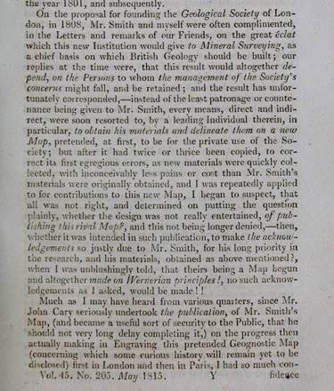
Extract of Farey, John, “Observations on the priority of Mr Smith’s investigations of the strata of England”, Philosophical Magazine’, vol XLV (1815).
Farey’s article explains in detail how William Smith’s ideas and findings have been used by other geologists without proper attribution. This extract criticises the methodology behind the research for the Society’s planned map of England & Wales. Although not named, the ‘leading individual therein’ of the Geological Society is clearly Greenough. Click to enlarge
|
Greenough would address Farey’s comments in the Memoir to his own map:
|
Greenough's personal copy of William Smith's 'A Delineation of the Strata of England & Wales...' (1815). Greenough collection, ref: LDGSL/947/6/B/4. Click to enlarge.
|
“…I have been accused of having acted, if not an unfair, at least an ungenerous part, by trespassing upon ground, which I knew to be, by right of pre-occupancy, his [Smith]. I certainly did know, as early as the year 1804, that such a map was begun; but I appeal to all the friends of Mr Smith, with whom I have conversed upon the subject, and especially to the individual who complains of my conduct, whether he, and they did not, for a long time afterwards, in consequence of a variety of circumstances which it is unnecessary to detail, consider its completion, and still more its publication, hopeless. In the belief that the work had been virtually abandoned by Smith, it was undertaken by me. In 1812…my map was presented to the Geological Society; and it had been more than a twelvemonth in the hands of the engraver when Mr Smith published his…I do not admit that any consideration of justice or delicacy required me to either abstain from constructing my map, in the first instance, or, when partly engraved, to request permission of the Geological Society to withdraw it. Mr Smith’s map was not seen by me till after its publication, and the use I have since made of it has been very limited. The two maps agree in many respects, not because the one has been copied from the other, but because both are correct…and the reasonings of two persons engaged on the same subject should invariably be the same.” [from Greenough, G B, ‘Memoir of a Geological Map of England: to Which are Added, an Alphabetical Index to the Hills, and a List of the Hills Arranged According to Counties’ (1820).]
Greenough’s research methodology, as we have seen, was to collate multiple sources together (published or otherwise) to analyse to help him determine the geological formations on his maps. When Smith’s map ‘A Delineation of the Strata of England & Wales with part of Scotland..’ was published in 1815, Greenough and the Society each received a copy of the first imprint around September of that year. Why would he not refer to Smith’s map since it was in his possession anyway and freely available to buy? From the brief notes on Greenough’s copy he certainly did look at it for the purposes of comparing it to his own map.
|
|
|
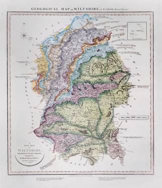
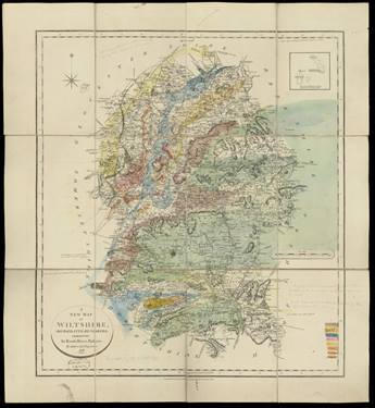
William Smith’s ‘Geological map of Wiltshire’, published by John Cary (1819). GSL Library collections. Click to enlarge.
|
|
Geological colouring, with a small number of pencil notes and a key by George Bellas Greenough dated February 1819, on base 'A New Map of Wiltshire Divided into Hundreds', published by John Cary, 1818. Greenough map collection, ref: LDGSL/ 947/6/D/11/6. Click to enlarge.
|
However ‘A Delineation of the Strata of England & Wales with part of Scotland…’ (1815) was not the only map which William Smith produced in the period during the run up to the publication of Greenough’s map. The map on the left is William Smith’s county map of Wiltshire, published by John Cary in January 1819. The draft map of Wiltshire on the right is by Greenough with an annotated date of February 1819, implying that it likely formed part of the research for his map. Both are, coincidentally or not, drawn on the same base map. Greenough’s notes make comments both about Smith’s map of Wiltshire and his 1815 map. About the latter he writes “Smiths Map more correct than Bucklands for this part of the Country (1815)". There is also a note marking the boundary line of the Forest Marble at the top of Greenough’s draft map. On Smith’s county map of Wiltshire this formation also appears outside of the marked topography.
<<Back to main page