Crowdsourcing
|
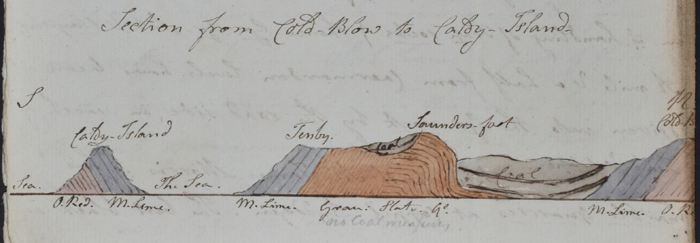
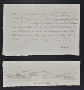
| Section of Cold-Blow to Caldy Island by Robert Halifax, from a letter to Greenough dated 28 September 1819. Halifax sent Greenough an account of his tour through South Wales in case it was of use for the Geological Map, giving an indication of how relatively late into the production process that data was still being collected. Greenough has annotated the section in pencil 'ors Coal measures'. Ref: LDGSL/947/1/HALIFAX. |
Despite the assertions that Greenough’s rudimentary map be published without delay, research on filling in the geology of the rest of the country continued right up until quite late on in the map’s production process.
Greenough’s modus operandi was to collect as much data as he could. Society Members, mine owners and other interested parties based in the regions were approached for their local geological knowledge, a number of whom would be referenced in the accompanying Memoir to Greenough’s map.
JOSEPH FRYER (1777-1855)
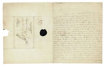
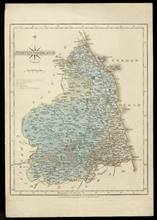
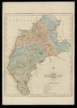
Joseph Fryer was a mining engineer of Lysick Hall, Cumberland, who corresponded with Greenough about his local region. The letter on the left from April 1814 contains Fryer's observations on the coal formations of Newcastle and Sunderland. Fryer also supplied Greenough with county maps from around the Lake District which he had geologically coloured.
|
|
 |
|
|
Letter from Joseph Fryer to Greenough, 12 April 1814. Greenough collection, ref: LDGSL/947/1/FRYER. Click to enlarge
|
|
Geological maps of Northumberland and Cumberland coloured by Joseph Fryer [1814]. Fryer sent a third map of Westmorland but this does not seem to survive.
Greenough collection, refs: LDGSL/947/6/D/1/1 & LDGSL/947/6/D/2/1] Click to enlarge
|
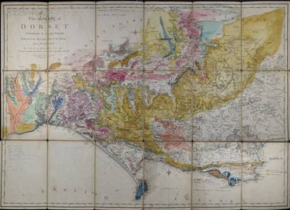
WILLIAM BUCKLAND (1784-1856)
A number of the Society’s Members also contributed detailed information from their own geological expeditions, including the Reverend William Buckland who was Professor of Mineralogy and later first Reader in Geology at the University of Oxford. Greenough even ventured out to accompany Buckland on a number of occasions, such as in May 1813 when he spent around four days travelling eastwards along the south coast of England from Lyme Regis. Buckland also acted as a conduit for providing geological information from others, such as his friend the Reverend William Daniel Conbyeare (1787-1857).
|
|
|
Geological colouring and notes by William Buckland on base map 'The County of Dorset surveyed by Isaac Taylor, reduced from the large map in six sheets...', published by William Faden, 1 July 1796. This map is one of two coloured on the same base map in the Buckland collection. The colour key on this version is in the hand of Greenough, indicating their collaboration. Ref: LDGSL/56/3/5. Click to enlarge
|
|
Copied extract of a letter from William Daniel Conybeare to William Buckland, on the coal shale and greenstone strata around the Nuneaton area, Warwickshire, with a small section, 1817. Greenough collection, ref: LDGSL/947/4/3/5/2. Click to enlarge
|
Greenough made plentiful use of published sources, both from his own personal library but also utilising the Society’s collections. Around the coastline of the map can be found numerous short notes on the history or geology of places which can be used to trace the books and journal articles he consulted.
NATHANIEL JOHN WINCH (1768-1838)
Nathaniel John Winch was a merchant based in Newcastle who developed an interest in the study of botany, particularly the geographical distribution of species around Northumberland, Cumberland and Durham. His devotion to the subject was considered to be behind the failure of his business in 1808 when he was declared bankrupt. An Honorary Member of the Geological Society, his paper "Observations on the Geology of Northumberland and Durham" [published in the Transactions of the Geological Society of London. Series 1, Volume 4 (1817)] was described in his obituary as “not containing much of originality in [its] views and researches...[but was]...at the time, of considerable utility.”
|
|
|
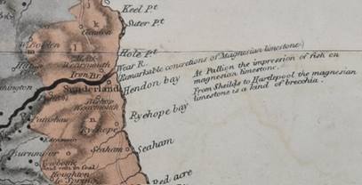
Extract from Greenough's map which likely references the fossil fish which appeared in Nathaniel John Winch’s paper "Observations on the Geology of Northumberland and Durham" (1817). On the right is the original artwork for the illustration which was published alongside the paper entitled 'Impression of a fish found in the Magnesian Limestone, in Mr [John] Goodchild's Quarry near Sunderland, the original specimen in the Sunderland Museum', by John Dobson [c.1814]. Ref: LDGSL/82/4. Click to enlarge.
|
THOMAS WEBSTER (1772-1844)
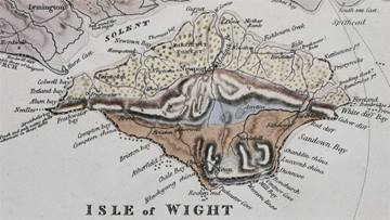
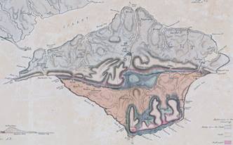
The most recent geological map of the Isle of Wight was compiled by Thomas Webster and published in 1816. Webster was the first employee of the Society who was initially engaged to look after the collections which had accrued as a result of ‘Geological Inquiries’ and the various committees. A talented artist, amongst his other duties was being the Society’s official draughtsman. He would also draw the outline for Greenough’s map.
|
|
|
L- Isle of Wight from Greenough’s Geological Map of England & Wales (1820)
R - Geological map of the Isle of Wight by Thomas Webster, published in Henry Englefield’s ‘A description of the principal picturesque beauties, antiquities, and geological phenomena, of the Isle of Wight’ (1816).
|
Webster’s map appeared in the antiquarian Henry Englefield’s book ‘A description of the principal picturesque beauties, antiquities, and geological phenomena, of the Isle of Wight’ (1816). A further indication that Greenough was familiar with the published work are references to two formations which appear as illustrated plates based on drawings by Webster.
|
|
 |
|
| |
 |
|
| |
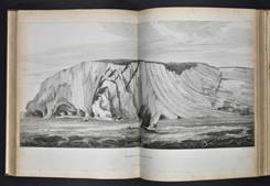
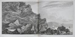
Top to bottom - Handfast Point showing the ‘curved strata of Chalk’ and the ‘contorted strata’ of Durlestone Head.
Published in Henry Englefield’s ‘A description of the principal picturesque beauties, antiquities, and geological phenomena, of the Isle of Wight’ (1816). Geological Society Library collection. Click to enlarge
|
|
| |
| |
|
|
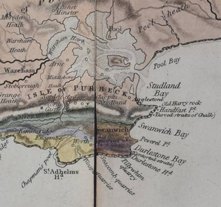
Isle of Purbeck from Greenough’s Geological Map of England & Wales (1820).
|
|
|
|
| |
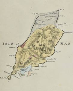
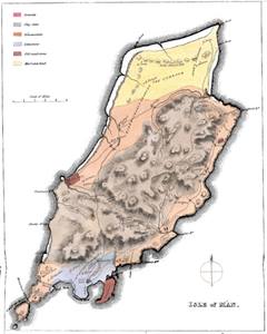
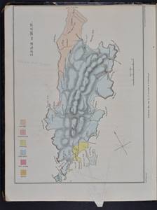
JOHN MACCULLOCH (1773-1835)
The earliest geological map of the Isle of Man was created by the Swiss mineralogist Jean-Francois Berger (1779-1833) and published in the Society’s Transactions in 1814. The similarities to the version on Greenough’s map is because Thomas Webster drew the base map for both. Geologically it is more closely aligned to the map by the geologist and surgeon John MacCulloch, which appeared in his book ‘A description of the Western Islands of Scotland, including the Isle of Man’ (1819). Greenough clearly consulted the Society’s copy as his annotations are written on the map plate.
|
|
|
|
|
L - Isle of Man Greenough’s Geological Map of England & Wales (1820)
M - Jean Francois Berger’s 1814 map, from Berger, J F, “Mineralogical Account of the Isle of Man”, Transactions of the Geological Society, vol 2 (1814), pp.29-65
R - John MacCulloch’s map of the Isle of Man, from the Society’s copy of ‘A description of the Western Islands of Scotland, including the Isle of Man’ (1819). This volume has undergone a later rebinding, which has substantially trimmed down the pages. Greenough’s annotations have been saved hence the strangely shaped tab at the bottom of the page. Click to enlarge.
|
<<Back to main page
Next: William Smith>>