 Image:
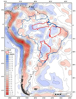
 Gravity and lithospheric thickness in South America. The Parnaiba basin is characterised by a negative free air gravity anomaly and relatively thick lithosphere. (Data courtesy of Professor D. McKenzie, Cambridge University)
Second, it is relatively accessible both for seismic acquisition and geological fieldwork. Outcrops around the margin of the basin are excellent and offer a good chance to tie the regional seismic data to outcropping chronostratigraphic equivalents. Third, the basin has only been lightly explored with fewer than 30 exploration wells and 25,000 line-km of 2D reflection seismic. Recent gas discoveries have been announced, and both oil and gas shows have been recorded in the past. However, the basin remains far from an established petroleum province.
Regionally, the Parnaiba basin has potential linkages with the other cratonic basins of Brazil and, in the context of Gondwana, the major African cratonic basins of North Africa and the Congo. As such, we believe that it represents an excellent laboratory to examine the fundamental driving mechanism of cratonic basins in general and to deepen the understanding of the basin-forming process and the controls on petroleum resource potential.
The project, expected to commence in early 2012, will conclude in 2015. It will involve collaboration with a number of universities from Brazil, Britain and the USA. The underlying philosophy will be to drive a truly integrated geological view of this accessible basin and use that to further our understanding of its resource potential and the fundamental driving mechanism of cratonic basins generally.