Graham Carlisle1 & Susan Turner2 examine yet another newly rediscovered facet of the ever-surprising work of Thomas Sopwith...
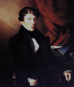
A new find on the auction circuit fit for Jubilee Year is an original manuscript production by Thomas Sopwith FRS FGS (1803-1879 - picture). Graham Carlisle, collector of 19th Century illustrations of north-eastern engravers, leapt at the opportunity without being sure of its historical context or accuracy. But from what he could see, this object was without doubt an astonishing labour of love and work of art.
One of the better-known auction websites has an antique seller facility called: “buy it now”. Early in May, Graham was periodically checking for old maps on Northumberland and Durham when he came across what has turned out to be one of the earliest geological cross-sections of Britain.
The item on offer was listed as: ‘Antique Map - limestone strata North of England 1839’. The seller had provided many images of what he considered to be a very large ‘print’ of “limestone strata”. A ‘print’, at an advertised length of “around 40 feet” (~13m) and dated 1839 seemed an unlikely object to Graham – unlikely, but not impossible. “Something at the back of my mind recalled the purchase, with associated publicity, of a very large ‘printed’ geological item of great importance” he says. Was this a geological map? A wall-mounted educational tool perhaps? This particular ‘antique map’ was newly listed; an immediate decision was required. And so Graham bought a black, tubular tin container (picture).
Graham has no geoscience background. His field of interest is the illustrative work of northeastern engravers working in the period from1760 to 1860, and it has often led him down a few random by-ways. What then, was he to make of this? What he had acquired was beyond his expectations - and so he sought some geological help from Sopwith researchers in an attempt to understand more about his find.
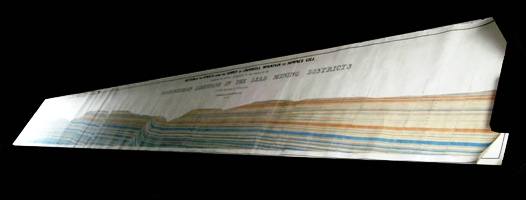
Picture right: The full length of the rediscovered 1839 Sopwith Strata Section unfurled (photo © G Carlisle & S Turner).
Graham, it turned out, had become the proud possessor of one of the first, and certainly the most extensive, hand-drawn coloured cross-sections of the geology of Britain. It covers the ground from Cross Fell to Hownes Gill in Co. Durham, a length given as ‘28 miles 12 chains 60 links’. And that amazingly precise work was carried out by Thomas Sopwith, one of the early 19th Century’s unsung heroes of geology, a man whose grandson (of the same name) far outshines him in fame and internet materials these days - think Sopwith Camel and Pup and Hawker and Armstrong Siddeley.
We think it is more than high time that we gave TS Senior his due for his early geological endeavours. Sopwith did become a Fellow of the Geological Society in late 1835 and his faithful constancy in recording 19th Century events has been of enormous use to more than one historian of science.
APPRENTICE

Left: The 1839 Sopwith Strata Section with the black circular tin container in the foreground (photo © G Carlisle).
Sopwith, coming from a Newcastle upon Tyne family of cabinet makers, became a young apprentice under J & T Dickinson, operators of lead mines in the North of England. It was undoubtedly then that he first devoured Westgarth Forster's (1809, 1821 2nd Ed.) classic section from Newcastle to Cross Fell, showing the underground structure. Forster had been the first to provide a stratigraphic column, although 18th Century cross-sections are known, from the work of White Watson and John Farey. Sopwith produced his own first book with sections in 1829, based on his apprenticeship years, when he spent much of his time walking the hills and dales learning by observation.
We are not yet sure why exactly he made this section, through the Carboniferous Limestone in the Lead Mining Districts of the North of England; but in 1839 (or possibly the year before) he was working on a model of part of Alston Moor lead mines and Nentsbury lead mines, Cumberland, (model XVI, illustrated in Turner & Dearman 1982). Sopwith exhibited on the Alston Moor strata at the 1838 British Association for the Advancement of Science (BAAS 1839) and on 6 November 1839 lectured to Durham University students about plans, sections, geological drawings, and models.
Since the 1820s Sopwith had honed his skills in isometric drawing and made sections (and a large one-off geological model) to show the structure of set areas, while in the late 1830s he had begun to think about making the smaller models (which have now become extremely collectable). We know however that he did exhibit his 1839 Strata Section at the British Association meeting in Newcastle in 1840. This was a pivotal meeting for him, as he met so many of the important geologists of the day and - at William Buckland's advice - proceeded to create and produce some of the most important three-dimensional models of geological structure, which were subsequently sold all over the world. This was when he penned the famous sketch of William Buckland en route with Louis Agassiz to look for evidence of glaciations (picture).
SPECTACULAR
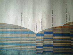 Right: Close-up of part of the 1839 Sopwith Strata Section showing detail of colour and structure (photos © G Carlisle).
This spectacularly beautiful new discovery measures a massive 42 feet long by 2 feet 5 inches deep backed onto heavy linen (pictures). The horizontal section is drawn at a scale of 300 feet to the inch, and the vertical section at 100 feet to the inch. It is in pen (Indian ink) and has been hand coloured, with the length made up of just fewer than 10 (9.73, to be precise), individual sheets of paper pasted onto a continuous, unbroken linen mount. Each sheet overlaps its neighbour by about an inch.
Technically, the sheets are of 19th Century 'Antiquarian' size (52.5 inches wide by 30.5 inches deep). Sopwith must have placed an order (to which supplier, we do not as yet know) for the entire length of high-grade thick blank drawing paper (This would have been very expensive; even more reason for the great care taken by TS). Probably because of the fractional differences in height for the supplied sheets (they might come with a ‘deckle’, because of the manufacturing process), they have been trimmed. Therefore, accounting for this and the overlap, the sheet size as measured is now 51.5 x 29.5 inches.
Sheets of drawing paper at this period were woven, and no watermark is present. At some stage in its long life the section was cut into two parts: length one is 14 feet 11 inches long; length two 27 feet and 3.5 inches long. Sopwith worked with patience and care. Every tiny change in direction of every single sequence is mapped out by the minutest of pinpricks - a magnifying glass is needed to see them.
From a distance the Section has every appearance of being printed; the ‘title’ is indicative of high-quality wood engraved lettering. The ‘font size’ is attractively balanced between each line within the title. There is a giveaway though; some of the lettering crosses the join of consecutive sheets in a manner that would never have been practical in print. Examination of the section shows that it was coloured after mounting onto the linen backing. Graham believes that the Sopwith Strata Section should properly be considered as unfinished. Although there are faint pencil notes (presumably by Sopwith) regarding colours to be used, one part of the Section carries only a pencil outline that remains uncoloured. Colour coding was one of Sopwith's fortés but this example predates his later work at the W B Lead Mines.
We have found references to the Crossfell to Hownes Gill Section in Sopwith's diary (via a quotation in Richardson's 1891 biography). It reads:
“On January 25th [1841]… Professor Sedgwick* also called and examined the large section of the strata from Howne’s Gill to the summit of Crossfell, which he honoured with the appellation of this ‘gorgeous section.’…”
Clark and Hughes in their Life and Letters of Sedgwick make no mention of the meeting, but that signifies nothing. Sopwith, unlike many, was one to note down every detail of his life - especially his meetings with eminent persons - as he was clearly a man on the rise. Sopwith later (1864) lectured on the section, and probably exhibited it. Wendy Cawthorne (Assistant Librarian, Geological Society) has informed us that the Society seems not to have a copy. However, we will be very happy to hear from any reader who is able to provide information that throws greater light upon this remarkable section.
Authors
1 Graham Carlisle is a collector of 19th Century engravings. 2 Susan Turner is a palaeontologist, museum designer and historian of science based in Australia
Further reading
British Association for the Advancement of Science 1838, Report 1839. vol VII, Catalogue of Philosophical Instruments, etc. in the Exhibition (appendix) 7-26; p. 26 mentions Sopwith's no 121 Model of Forest of Dean, no 122 Sections of strata in Dean Forest, no 123 Alston Moor strata and mining operations.
Dearman, W.R. 1985. Westgarth Forster models. Proceedings of the Geological Association 96(2), 97-107.
Dearman, W.R. and Turner, S. 1980. Discovery of working drawings for the Sopwith models of 1841 at the Hancock Museum. The Geological Curator, 2 (8): 467-95.
Ford, Trevor D. 1967. The first detailed geological sections across England, by John Farey, 1806-8. Mercian Geologist 2, 41-49.
Forster, Westgarth 1809. A Treatise on a Section of Strata, commencing near Newcastle upon Tyne, and concluding on The West Side of the Mountain of Cross-Fell. With Remarks on Mineral Veins in General, and Engraved Figures of Some of the different Species of those Productions. To which are added Tables of the Strata in Yorkshire and Derbyshire. The whole intended to Amuse the Mineralogist, and Assist the Miner in his Professional Researches. Newcastle. Preston and Heaton i-viii, 156pp.
Richardson, B. W. (1891) Thomas Sopwith, M.A., F.R.S. Longmans, Green & Co., London, 400 pp
Sopwith, Robert 1994. Thomas Sopwith Surveyor. An exercise in Self-Help. The Pentland Press Edinb, Cambridge, Durham, USA 266pp
Sopwith, Robert 2001. Thomas Sopwith: The Allenheads Years 1845-71. Nenthead : North Pennines Heritage Trust, 8, 32 pp.
Sopwith, T. 1829. Geological sections of Holyfield, Hudgill Cross Vein and Silver-band Lead Mines, in Alston Moor and Teesdale, showing the various strata and subterranean operations. Engraved on three copper-plates. Edward Walker, Newcastle, 11 pp. & John Weale, Taylor's Architectural Library, London.
Sopwith, T. 1833. An Account of the Mining Districts of Alston Moor, Weardale, and Teesdale, Alnwick, etc. W. Davidson, Alnwick.
Sopwith, T. 1864. Section of strata from Hownes Gill to Cross Fell, paper read at British Association 33rd meeting, Newcastle upon Tyne Aug-Sept 1863. Report, p. 88.
Thackray, John C. (ed.) 1999. To see the Fellows fight: eyewitness accounts of meetings of the Geological Society of London and its Club, 1822-1868. British Society for the History of Science Monographs, Faringdon, Oxon.
Turner, S. and Dearman, W.R. 1979. Sopwith's Geological Models. Les maquettes géologiques de Sopwith. Bulletin International Association of Engineering Geologists, no. 19: 331-345.
Turner, S. and Dearman, W.R. 1982. Thomas Sopwith's large geological models, Proceedings of the Yorkshire Geological Society, 44: 1-28.
Turner, S. 2011. Thomas Sopwith, the miner's friend: his contribution to the geological model-making tradition. In: Ortiz, JE, Puche, O, Rabano, I & Mazadiego, LF eds History of Research in Mineral Resources. INHIGEO-2010 volume, Cuadernos del Museo Geominero, 13, Instituto Geologico y Minero de Espana, Spain. 177-192.