Product has been added to the basket
Articles

Bruce Yardley appointed Chief Geologist

Bruce Yardley (Leeds University) has been appointed Chief Geologist by The Radioactive Waste Management Directorate (RWMD) of the Nuclear Decommissioning Authority (NDA).

Chartership news

Chartership Officer Bill Gaskarth reports on a projected new logo for use by CGeols, advice on applications and company training schemes

Climate Change Statement Addendum

The Society has published an addendum to 'Climate Change: Evidence from the Geological Record' (November 2010) taking account of new research

Cracking up in Lincolnshire

Oliver Pritchard, Stephen Hallett, and Timothy Farewell consider the role of soil science in maintaining the British 'evolved road'

Critical metals

Kathryn Goodenough* on a Society-sponsored hunt for the rare metals that underpin new technologies

Déja vu all over again

As Nina Morgan Discovers, the debate over HS2 is nothing new...

Done proud

Ted Nield hails the new refurbished Council Room as evidence that the Society is growing up

Earth Science Week 2014

Fellows - renew, vote for Council, and volunteer for Earth Science Week 2014!  Also - who is honoured in the Society's Awards and Medals 2014.

Fookes celebrated

Peter Fookes (Imperial College, London) celebrated at Society event in honour of Engineering Group Working Parties and their reports

Geology - poor relation?

When are University Earth Science departments going to shed their outmoded obsession with maths, physics and chemistry?

Nancy Tupholme

Nancy Tupholme, Librarian of the Society and the Royal Society, has died, reports Wendy Cawthorne.

Power, splendour and high camp

Ted Nield reviews the refurbishment of the Council Room, Burlington House

The Sir Archibald Geikie Archive at Haslemere Educational Museum

You can help the Haslemere Educational Museum to identify subjects in Sir Archibald Geikie's amazing field notebook sketches, writes John Betterton.

Top bananas

Who are the top 100 UK practising scientists?  The Science Council knows...

Officers with maps...


British troops (of the Queen’s Own Oxfordshire Hussars: a Territorial Army unit) entrenched near Zillebeke, east of Ypres in Belgium, February 1915

Ted Rose* on how groundwater prospect and engineering geology maps compiled for the Western Front pioneered militarily applied geology in the British Army

Geoscientist 22.03 April 2012


Steve Matthews (Geoscientist 21.6, July 2011) recently described one way in which the modern British Army makes operational use of geologists. Another is by the compilation of specialist geotechnical maps to help guide military planning. Such maps for recent operations are not yet in the public domain, but the principles that still guide them were established during the First World War and developed in the Second. Long clouded in secrecy, details of that process are now being progressively revealed, especially in recent publications of the Geological and British Cartographic Societies.

Picture above: British troops (of the Queen’s Own Oxfordshire Hussars: a Territorial Army unit) entrenched near Zillebeke, east of Ypres in Belgium, February 1915

Some military applications of geology have been apparent for over 200 years. Napoleon Bonaparte was the first general to take geologists as such on a military operation (the invasion of Egypt, 1798). The future British Geological Survey was founded in 1835 and financed until 1845 under military (Board of Ordnance) auspices, and geology was taught intermittently during the 19th Century at all army officer training institutions in the UK. However, not until World War I were geologists deployed as such to serve on a battlefield: the Western Front.
For most of the 1914-18 War, the Western Front extended from the North Sea coast south across Belgium and northern France to the frontier of Switzerland: some 740 km. A British Expeditionary Force (BEF) deployed to its northern sector from August 1914. Its front line position fluctuated with the ebb and flow of battle, but once the Front had largely stabilised into a zone of trench warfare in late 1914, the BEF held the ground approximately from Nieuport on the Belgian coast south to Amiens in France, a distance of about 130 km.

Fig 1

TERRAINS

Geologically, the BEF occupied land of three terrains. The first was a coastal zone of contemporary sand dunes, and Quaternary sediments reclaimed (as ‘polders’) from the sea. The second consisted of the Flanders Plain, mostly underlain by a bedrock sequence of alternating (mostly Lower Eocene) mudrocks and weakly cemented sandstones (similar to the London and Hampshire Basins in England). The third comprised the plateaux of Picardy and Artois, underlain by bedrock of Upper Cretaceous Chalk (similar also to that of southern England).
The scale and intensity of largely static warfare on the Western Front stimulated many technical innovations. The German Army was quicker than the British to make use of geological expertise, beginning in 1914. By 1916 it had developed a military geological organisation as such, with 29 teams of geologists, one for each section of the ‘military mapping and survey’ service as then constituted. The British Army made slower use of geologists, as two particular problems became evident.

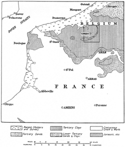
Picture: Near-contemporary geological sketch map of Belgium and northern France centred on the British-occupied region of the Western Front in World War I: area of Figure 7 outlined

WATER SUPPLY

The BEF expanded progressively from one to five armies. At its peak in 1916 it comprised some 1.5 million men and 500,000 horses/mules (mostly to transport stores forward from railheads, rather than as mounts for cavalry!). As numbers of men and animals increased, water supply became a problem. Each man/animal was calculated to require 10 gallons (45 litres) of water per day to meet all requirements. However, near the front line both surface and ground waters were vulnerable to pollution by munitions, ordure, dead bodies of men and animals, while pipelines were vulnerable to damage. Water from civilian wells was usually insufficient to support the high concentration of troops.

The problem was solved by innovations that included mobile rigs, bought from the USA, to drill deep boreholes; air lift pumps raised water quickly and in quantity from these depths; Well Boring Sections in the Royal Engineers (one per army) were formed to operate the new drilling equipment; and a geologist was appointed to serve as a staff officer at BEF General Headquarters to guide drilling for potable water. His name was Lieutenant (later Captain) W B R King.

Lieutenant Bill King, at Versailles in France, September 1915; photo courtesy of his daughter, Professor C. A. M. King (from Rose & Rosenbaum 1993)
Born in Yorkshire in 1889, ‘Bill’ King had graduated from the University of Cambridge with 1st class honours in geology in 1912, and joined the Geological Survey of Great Britain. On the outbreak of war he was undertaking fieldwork in Wales, but volunteered for service as an infantry officer in the British reserve forces (the Territorial Army). He was commissioned as a 2nd Lieutenant in the Royal Welsh Fusiliers in September 1914.

Picture: Lieutenant Bill King, at Versailles in France, September 1915; photo courtesy of his daughter, Professor C. A. M. King (from Rose & Rosenbaum 1993)

When the Survey’s Director (Aubrey Strahan) was asked by the BEF engineers to nominate a geologist to provide ‘expert’ advice on water supply, King was thus an obvious choice: young, physically fit, enthusiastic, and of proven geological ability. In April 1915 he was appointed to the War Office in London, to assist and be trained by Strahan in war-related hydrogeological work, before joining the staff of the BEF Chief Engineer (later re-titled Engineer-in-Chief) in France.He served with the BEF from June 1915 until hostilities ended, in November 1918. His role during this time was (where feasible) to supervise and direct the drilling of boreholes to supply drinking water to British forces, and to develop specialist water supply maps to be used by military planning staffs, or by water supply engineers in the many cases where it was impracticable for him to be present in person.

King compiled maps that included:

Fig 3 From 1915, a set of 14 water supply maps at 1:100 000 for the whole of Belgium and the enemy-occupied territory of northern France, plotting all the information about existing civilian water supplies that could be gleaned from a variety of sources, including geological maps published before the war.

Image: Part of World War I water supply map of Belgium, 1:100 000 scale series: © British Library Board catalogue reference Maps 14317.(160), showing information about existing civilian supplies derived from sources including topographical and geological maps
Fig 4
In May 1916, a map at 1:250 000 for Belgium and northern France showing the relative abundance of water in the summer months: quality indicated by colour type (blue = good, purple = fair, red = poor), quantity by colour intensity (dark = abundant, medium = moderate, light = scarce).

Image: Part of map at 1:250 000 for Belgium and northern France showing the relative abundance of water in the summer months: © British Library Board catalogue reference Maps MOD GSGS 2818. Water quality indicated by colour type (blue = good, purple = fair, red = poor), quantity by colour intensity (dark = abundant, medium = moderate, light = scarce)
Fig 5
In 1918, another map at 1:250 000 for Belgium and northern France showing the region divided into 15 areas according to the probable sources of water supply and the type of engineering plant required.

Image: Part of map at 1:250 000 for Belgium and northern France showing the region divided into areas according to the probable sources of water supply and the type of engineering plant required

Fig 6
Also in 1918 and at 1:250 000, a map for the Somme region of France (the southern region contested by the BEF, underlain mostly by Cretaceous Chalk, in which most British military boreholes were emplaced), showing contours of the surface of a marl horizon relatively impermeable to water as well as topographical contours – since to get a good yield from boreholes in this region, it was calculated that the bore penetrate not less than 15 m of water-bearing Chalk. Potential drilling depths could be calculated from the map.

Image: Topographical map at 1:250 000 for the Somme region of France overprinted with contours for the surface of a marl horizon relatively impermeable to water

King guided emplacement of at least 470 British military boreholes during the war. Some of his maps (particularly at 1:40 000) assisted development of a water supply infrastructure within areas already occupied by the British armies. Other maps, such as those illustrated here, assisted planning and procurement of equipment for advance into new areas, e.g. that by the British Third Army, when between 21 August and 11 November 1918 some 300 000 men and 100 000 horses/mules crossed a zone about 20-25 km deep with almost no surface water to sustain them.

Fig 7

TUNNELS & DUGOUTS

By 1915 the opposing forces were massively entrenched and the front line increasingly fortified. Mining was therefore developed by both sides on an unprecedented scale as a means of breaching fortifications. Tunnels were driven forward beneath enemy positions, charged with explosives, and detonated prior to infantry attack – thus effecting optimum surprise.

Image: Simplified topographical map of the Ypres Salient of the Western Front during 1917, showing the position of the town of Ypres (now Ieper) relative to the high ground that forms the Wytschaete-Passchendaele Ridge (cf. Fig. 1), and the advancement of the British front line eastwards from June to December 1917; Wytschaete area outlined.

In the British sector, such mine and countermine warfare reached a peak in 1916. The BEF raised nine Royal Engineers tunnelling companies in 1915, expanding these to a total of 25 plus three companies from Canada, three from Australia, and one from New Zealand, by the end of June 1916. The BEF thus had about 25,000 British and Commonwealth troops actively engaged in military mining. This phase of the war culminated in the Battle of Messines: an attack on German troops occupying the southern part of the Wytschaete-Passchendaele Ridge, to the SE of the town of Ypres (Ieper in Flemish).

The attack was planned for the summer of 1916 but postponed to 7 June 1917. Near simultaneous discharge of 19 mines, whose tunnels in total contained nearly 450,000 kg of high explosive, across a front of 16 km, prior to massed infantry assault, ranks as the greatest and most successful operation ever carried out in mine warfare.

Fig 8 Thereafter, mining activity gradually declined. Mining was effective only against a strongly held front line, and by the close of 1917 the front was held more by artillery firepower than infantry manpower. As mining declined, so BEF tunnelling companies were increasingly diverted to the construction of dug-outs to shelter troops from artillery bombardment. To guide excavation, between September 1917 and June 1918 a series of twelve specialist geological maps was compiled and widely distributed to troops of the British Second and Fifth Armies.
In total, these maps covered the whole of the Wytschaete-Passchendaele Ridge and adjacent areas, an area of about 500 km2, at a scale of 1:10 000. Printed in England by the Ordnance Survey at Southampton, they were the first series of relatively large-scale engineering-environmental geology maps to be published for British use, and arguably the first published large scale engineering geology map series per se.

Image: Geological map of Wytschaete, Belgium, original at scale of 1:10 000, showing classification of ground according to its suitability for the excavation of dug-outs: shades of red indicate relatively ‘good’ (dry) strata, ‘bad’ (wet) units are coloured in shades of blue-green

EDGEWORTH DAVID

Fig 9 The maps were primarily the work of Major (later Lieutenant-Colonel) Tannat William Edgeworth David. Born in Wales in 1858 and educated at the University of Oxford, David had emigrated to Australia and achieved considerable academic distinction. Professor of Geology and Geography at the University of Sydney, he arrived at the Western Front in May 1916 with the Australian Mining ‘Battalion’ he had helped to raise: a white-haired grandfather 58 years of age.

Image: Major Edgeworth David, photographed prior to his arrival at the Western Front in May 1916; from University of Sydney Archives, courtesy of Peter Davies (from Rose & Rosenbaum 1993)

Initially David served as the geological adviser to guide BEF mining operations, but generated the new maps when military priorities changed. Using data transcribed from Belgian geological maps published before the war, which distinguished rock units according to their inferred geological (i.e. chronostratigraphic) age, and data from c. 1000 British and Belgian boreholes, he compiled maps that classified the ground strictly according to its suitability for dug-out construction. Lithostratigraphical units were coloured primarily in shades of red to indicate relatively ‘good’ (dry) strata, contrasted with ‘bad’ (wet) units coloured in shades of blue-green.

About 180 British dug-outs were constructed in the Ypres region, of many types but typically with some six metres of cover to be proof against heavy howitzer or mortar fire. Geology proved to be a significant influence on the depth of their construction along the whole of the Wytschaete-Passchendaele Ridge.

Fig 10

LEGACY

At the end of hostilities, Edgeworth David returned to Australia. He died in 1934 and was accorded a state funeral in recognition of his many accomplishments: a rare (perhaps unique?) honour for a geologist. Bill King returned to employment by the Geological Survey in the UK, before appointment in 1920 to a teaching post at the University of Cambridge, and in 1931 promotion as Professor of Geology at University College in the University of London.

Image: Part of World War II airfield construction probability map of NW Europe at scale of 1:1million: areas of pale colour are ‘good’, intense colour ‘bad’ (courtesy Shotton Archive, Lapworth Museum of Geology, University of Birmingham)

King rejoined the British Army at the start of World War II, in September 1939. After distinguished service once more in France, he was evacuated with the new British Expeditionary Force via Dunkirk in 1940. Back in the UK, he was later to generate new types of geotechnical maps for military use. As the Staff Officer (Geologist) at 21st Army Group headquarters, helping to plan for the Allied liberation of Normandy, he influenced the decision not to invade via Cotentin, but through Calvados, since the geological conditions there were more favourable for the rapid construction of temporary airfields deemed necessary to provide area superiority over the bridgehead. A simplified map compiled in mid 1943 using essentially the red/blue and colour intensity contrasts pioneered in water supply and dug-out suitability maps of World War I, made the distinction clear.


Fig 11 King was released from the Army (as a Lieutenant-Colonel) in October 1943 to become Woodwardian Professor of Geology at Cambridge. By then he had guided foundation of the Geological Section of the Inter-Service Topographical Department: an ‘intelligence’ unit that was to generate numerous geotechnical maps and reports during the rest of the war. Also, he had groomed one of his pre-war undergraduate students at Cambridge, Fred Shotton, to be his successor at 21st Army Group HQ. There Shotton compiled a wide range of specialist maps (notably for beach trafficability, suitability for rapid construction of airfields, and groundwater prospects).

Image: Key to airfield construction probability map (courtesy Shotton Archive, Lapworth Museum of Geology, University of Birmingham)

Even after release to Cambridge, King helped to compile a series of groundwater prospect maps that assisted the Allied campaign eastwards across northern France and the Low Countries to victory in Germany. Postwar, he became the geological adviser to the UK War Department (later Ministry of Defence), and helped to create a small pool of geologist reservist officers to maintain geological expertise for the British Army. He died in 1963, but the recent work of Steve Matthews in Afghanistan reveals that successors of his ‘pool’ still exist, in the Territorial Army.

King’s World War I experience generated an enduring legacy. He recognised that as a geologist advising non-geologists tasked with decisions involving the best use of ground, his advice had to be clearly relevant to the specific problem in hand (e.g. sites for boreholes to abstract potable groundwater, excavations for dug-outs, or rapid construction of temporary airfields); that it made more impact to communicate initially with simplified illustrations (e.g. maps) than technical words; and that in the military context at least, non-geologists seeking advice were interested fundamentally in just two concepts: ‘go’ and ‘no-go’. It might be necessary to introduce a third (intermediate) category of ‘slow-go’, but anything more complex was likely to lose impact. These principles still apply.

* Honorary Research Fellow in Earth Sciences, Royal Holloway, University of London

References

  1. Robins, N.S., Rose, E.P.F. & Clatworthy, J.C. (2007): Water supply maps for northern France created by British military geologists during World War II: precursors of modern groundwater development potential maps. Quarterly Journal of Engineering Geology and Hydrogeology, 40, 47-65.
  2. Rose, E.P.F. (2009a): Water supply maps for the Western Front (Belgium and northern France) developed by British, German and American military geologists during World War I: pioneering studies in hydrogeology from trench warfare. The Cartographic Journal, 46, 76-103.
  3. Rose, E.P.F. (2009b): Military men: Napoleonic warfare and early members of the Geological Society. In: Lewis, C.L.E. & Knell, S.J. (eds) The making of the Geological Society of London. Geological Society, London, Special Publications, 317, 219-241
  4. Rose, E.P.F. & Clatworthy, J.C. (2007): Specialist maps of the Geological Section, Inter-Service Topographical Department: aids to British military planning during World War II. The Cartographic Journal, 44, 13-43.
  5. Rose, E.P.F. & Clatworthy, J.C. (2008a): Fred Shotton: a ‘hero’ of military applications of geology during World War II. Quarterly Journal of Engineering Geology and Hydrogeology, 41, 171-188.
  6. Rose, E.P.F. & Clatworthy, J.C. (2008b): Terrain evaluation for Allied military operations in Europe and the Far East during World War II: ‘secret’ British reports and specialist maps generated by the Geological Section, Inter-Service Topographical Department. Quarterly Journal of Engineering Geology and Hydrogeology, 41, 237-256.
  7. Rose, E.P.F. & Mather, J.D. (eds) (2012): Military aspects of hydrogeology. Geological Society, London, Special Publications, 362, in press.
  8. Rose, E.P.F. &Rosenbaum, M.S. (1993): British military geologists: the formative years to the end of the First World War. Proceedings of the Geologists’ Association, 104, 41-49.
  9. Rose, E.P.F. & Rosenbaum, M.S. (2011): British geological maps that guided excavation of military dug-outs in Belgium during World War I. Quarterly Journal of Engineering Geology and Hydrogeology, 44, 293-306.
  10. Rose, E.P.F., Clatworthy, J.C. & Nathanail, C.P. (2006): Specialist maps prepared by British military geologists for the D-Day landings and operations in Normandy, 1944. The Cartographic Journal, 43, 117-143.
  11. Rose, E.P.F., Clatworthy, J.C. & Robins, N.S. (2010): Water supply maps for North-west Europe developed by British military geologists during World War II: innovative mapping for mobile warfare. The Cartographic Journal, 47, 55-91.