
Other sites of Geological Interest
Introduction
This final section consists of brief accounts, each describing a place in Gower that illustrates something interesting and significant about geology and geologists. It is by no means exhaustive, and such is the richness and variety of the peninsula that nearly every square yard of it has something to tell us.
The localities I have included are all easy to locate with the aid of an Ordnance Survey map, so there are no detailed instructions as to how to find them. Most of them are somewhere near those places described in Part II, and are easy to incorporate into your walks and tours around Gower.
Misfit streams and vanished rivers
Mention has already been made (Tour 1, stop 1) of the Clyne Valley and its misfit stream, a river too minor to have been responsible for the erosion of the valley in which it runs. The Burry Pill is, similarly, a misfit stream in the Cheriton Valley (Tour 2, Looking north). The reason for the existence of these dramatic incongruities is rooted in the glacial history of the region, since during the regressive phases of glaciation, meltwater beyond and below ice-sheets often created highly energetic torrents, charged with glacial debris.
There is another element to the drainage of Gower that deserves mention, and it has to do with the very large areas of land underlain by Carboniferous Limestone. Limestone dissolves in water, and streams consequently create for themselves extensive underground courses to which they often retire in periods of drought when the water table is low. After heavy rainfall, on the other hand, when excessive water is available, the extra runoff may make an appearance at surface, but some sections of valleys in this area may be almost permanently dry.
Added to the ordinary process of normal stream-erosion, we therefore have the processes that operate in so-called "karstic" terrain - i.e., solution processes found in limestone areas. Hitherto it was thought that the dry valleys of Such areas as Gower had been created by the collapse of underground caverns. Isolated collapses give us swallets and sink-holes, as we have seen near Cilibion (Tour 2). However, it is now known that almost none of the dry valleys of the UK were formed this way. Those valleys, including Cheddar Gorge and the various chalk dry valleys, formed instead as a result of surface fluvial erosion by summer meltwater in periglacial environments - i.e., around the edges of ice sheets - where underground drainage through the limestone or chalk was blocked (or severely hindered) by permafrost.
Nevertheless, in the walls of these valleys, caves are common. These caves would once have been minor lateral extensions of now vanished caverns. Evidence of water-working can be seen in their walls. The height of many of these caves above the valley floor suggests that the formation of these cave-systems took place at a time when the water-table was generally higher than it is today. The implication of this is that they may date from the immediate post-glacial period.
 The valley joining the village of Ilston with the Gower Inn at Stonemill (Parkmill east) is an example of such a valley (MR 5589). You enter it via the churchyard; here the stream may or may not be flowing. Notice the large, gaping cavern across the valley as you go through the gate at the back of the graveyard. The stream (known as the Killy Willy, which runs to sea as Penard Pill, Three Cliffs Bay) appears and vanishes erratically throughout its course as far as the Gower Inn.
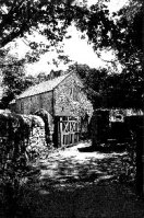
(Picture - Ilston's ancient church)
From Parkmill proper, a second valley may be explored which shows these features even more graphically. Go past the shop and along the lane which leads to the sawmill and the ford (you will have to leave your car at the shop, but if you do, please buy something). Cross the ford by the footbridge and turn right to reach Green Cwm.
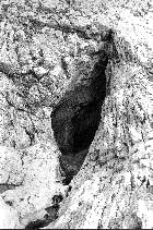
 Keep your eyes open as you go for a water-pumping station behind the trees to the right. Here is where the stream emerges, after flowing underground for the entire length of the valley opening out on your right. Go through the wooden gate and make your way up the gravel track. A little way on, on the eastern side and opposite the chambered long-barrow known as Giant's Grave, is Cathole Cave (picture), set in Cathole Rock. Examination of the walls of this cave will reveal obvious signs of water-working which any caver will immediately recognise (shallow rippling effect). It is quite easy to imagine this cavern as the minor side-chamber of a main watercourse, now long since collapsed.
[Author's note: I am told by luckier people than I (who can still visit Gower regularly) that since this guide was written, a visitor car park has been built near to the water pumping station and treatment works, mentioned above. Ted Nield]
Other small caves and entrances may be seen along the valley, and at the Llethrid Bridge end, the river can be seen (to the west of the path) disappearing into the ground.
Travelling out of Blackpill by the Mayals Road (B4436), you will find yourself descending a long hill into Bishopston Valley once you have crossed Clyne Common. Just beyond the left-turn to Bishopston itself, there is a track leading to some rough ground on the right where you may leave your car.
Notice the quarry opposite. It is the last working quarry in Gower, and it is removing the D1-2 Zone limestones (Fig. 3 ) which underlie the 'Black Lias' we saw at Clement's quarry, Oystermouth. These Upper Limestone Shales (D3 Zone) are immediately below the Millstone Grit (Namurian), and it therefore follows that the green field to the north of the quarry underlain by D3 and Namurian rocks. The Namurian also extends under Barland Common.
Leave your car and follow the track towards the river. At the ford, you will be able to examine the Namurian in the riverbed, and if you follow the stream a little way, you will come eventually to the sink-hole where it vanishes into its cave-system. After copious rain, some water will continue to flow above ground, and will fill the ford at Bishopston old village.
Bishopston Valley, which extends from the old village to the coast at Pwll-Du, is perhaps the most mysterious and exciting of all Gower cwms. It has a wildness and a solitude which no other can match, and in the summer the moist heat which the tree-canopy can trap makes it seem almost tropical.
Access to the valley is along the stream bed from the ford at Bishopston (near the church -MR578894). The first typical feature you encounter is a vast pit with sheer walls just to the right of the path. A little way along from this, the stream bed is obviously only very infrequently flooded, and the valley itself is narrow and gorge-like, with no active surface-stream to widen it.
Dramatic evidence of the existence of subsurface water is provided at Guzzle Hole (MR 575884), a cavern on the right of the path, at the back of which the river can be heard and seen to be flowing vigorously. It comes to the surface not far downstream, and you will notice that soon after it becomes emergent the valley becomes correspondingly wider, since it now has an active, erosive agent at the surface.
On the opposite side of the valley from Guzzle Hole is a mine adit surrounded by the ruins of some small buildings. This is the Long Ash Mine, and it was working in the middle of the 19th Century, producing silver and lead ore from a lode formed by mineralisation along a fault. The shaft continues into the valley-wall for about 200 feet, and should on no account be entered. It ceased to be productive in 1854.
At Pwll-Du the river is dammed up behind the storm-beaches, through which it must percolate to reach the sea. You have now arrived at the next site of particular geological interest.
Pwll-Du and the quarrymen of Gower
Many men once walked down the Bishopston Valley to work the quarries at Pwll-Du. Until the beginning of the 20th Century, rights of "cliffage" were awarded to certain privileged farming tenants, who could then strip limestone from the slopes of Pwll-Du Head for shipping to Devon, where it was used in making agricultural lime.
Coastal quarries like this were established all around Gower from Mumbles to Rhosili, but the accident of seaward-dipping strata which characterises the promontories of east Gower made quarrying at these places (Mumbles, Pwll-Du, Oxwich) especially convenient.
Blocks were removed along deep gullies, which can still be seen quite clearly, especially from the eastern side of the beach. The stone was then piled up on the low shore and marked with posts. Ships would enter the cove at high tide, locate the posts and beach as closely to them as possible. The consignment was then loaded at low tide.
An interesting technique which the Devon shipmasters employed, was to scuttle their vessels(before the tide was fully out) by opening the sea-cocks. Once the ship was resting on the bottom, the cocks were closed, so that the hull remained full of water when the tide retreated. This water broke the impact of the first blocks as they were hurled aboard. Once laden, the cocks were opened again, the water drained off, and the smack re-floated when the tide returned.
The houses you now see in the hamlet of Pwll-Du were once public houses, slaking the thirst of the quarrymen with beer brought down the lanes from Pyle Corner (see below). The last to close, after having tried to survive on holiday trade, was the Beaufort Arms. It is marked as such on the older Ordnance maps of the area.
Leaving your car at Bishopston, take the lane from Pyle Corner (MR 580883) that goes past the front of the bank and the shop; follow it around a sharp bend and carry on for about a mile until you reach the top of the cliff. From here, the track leads down into Pwll-Du to the west. Those not wishing to trek from Bishopston should park somewhere around Pyle Corner.
It is interesting to note that the magnificent shingle-banks of Pwll-Du are probably entirely the result of the quarrying operations there. These rejected all fine rubble, because it took too long to load. The weird landforms on the side and top of the head, which are the overgrown remnants of the quarries, have given the place the appropriate local name of Goonland.
Paviland Cave; Dr Buckland and the scarlet woman
 Park your car at Pilton Green and follow the signpost on the south side of the road (MR 437872) to the coast. This path descends into a narrow ravine that opens to the sea between two towering masses of limestone. Half way up the right-hand cliff is Goat Hole, more commonly called Paviland Cave, one of the most significant and notorious bone-caves in Britain. You have to be fairly intrepid to reach it by clinging to the western wall of the valley and traversing around, and most visitors prefer to clamber down to sea-level and climb back up again (you will understand why this is necessary when you get there). Unfortunately, for this to be possible, the tide must be out. Otherwise the waves prevent access.
Here in January 1823, William Buckland, (who was a founder of the Geological Society of London and the first professor of geology at Oxford) unearthed the left half of a male human skeleton. Because the find was made together with certain items of jewellery, Buckland wrongly (and with a delightful naivety) decided that the skeleton was of a female, and it subsequently became known as the 'Red Lady' because of the reddish iron stain which had coated the bones.
Buckland, who was looking for evidence of Noah's Flood, and who, while quite prepared to believe in the existence of pre-diluvian mammoths, bears and hyaenas in Britain, was not prepared to accept that man existed here before God's vengeance was visited upon mankind.
Therefore, he could not appreciate that he had actually discovered an example of Palaeolithic Man, dating from about 18,000 years BP, a time when Gower was just emerging from the grip of the Devensian glaciation and lay in icy tundra at the edge of the ice-sheet. The sea would have been very much lower at that time, because so much of the world's water was locked up in the ice-caps. The present-day coast would have been no more than a line of rocky bluffs overlooking a wide expanse of forest stretching far away towards the ancestral River Severn. Bears, hyaenas and wolves would have lurked among its gloomy pines, while on the margins of the ice-sheet to the north, woolly mammoth roamed in sluggish herds. Bones of all these animals were found in the cave deposits, and this posed something of a problem for the professor.
For if these pre-flood animals occurred in the same deposits as a human skeleton, did not this mean that the skeleton was of the same vintage? Buckland could not accept the obvious conclusion that the evidence demanded, and he decided that the Red Lady must have been buried in the cave at a much later date.
But why? What was this mysterious woman doing there in this cave? Buckland came to the sort of conclusion that tells us more about the psychology of the man than about the true nature of his subject. To explain her solitary fate, he wrote, in his Reliquae Diluvianae (Murray, 1823, p.90):
'The circumstance of the remains of a British camp existing on the hill immediately above this cave, seems to throw much light on the character and date of the woman under consideration; and whatever may have been her occupation, the vicinity of a camp would afford a motive for residence, as well as a means of subsistence, in what is now so exposed and uninviting a solitude'.
The 'British camp' he refers to can be examined quite easily, and is marked on the map as a 'settlement'. There are many such fortified promontory-settlements on this stretch of coast, and they date from the early Iron Age.
Port-Eynon and T.Neville George
 Port-Eynon is a small village lying at the head of a bay created by the Port-Eynon Syncline, which brings soft Namurian shales down to sea-level. As you descend the road into the village, just after the turning for Overton, the road begins a steep, left-hand bend; immediately after this a narrow lane branches off to the left. Here, at the back of the parking-space belonging to the first cottage, is the main (and only easily accessible) outcrop of Triassic rocks on Gower
- PDF on the subject of Gower's unconformable Triassic, including a sketch of the locality
The relationship between young rocks which lie on top of folded and eroded rocks of earlier epochs tells us forcibly about the vast interval of time which separates one formation from the other. It is called an unconformable relationship, and the plane which separates the two units (and which represents this enormous gap of time) is called an unconformity.
On the headland that dominates Port-Eynon bay are yet more quarry workings (see above). Here, too, the boats from Devon came to load the limestone, and the ballast which they carried on their outward journey, and which was jettisoned out at sea, is now to be seen as strange, blue-green cobbles on Overton Mere. They are a form of erratic, but carried by human agency!
Port-Eynon is geologically significant for another reason. The village was especially fortunate, in the latter decades of the last century, to have as schoolmaster there, a Mr George. His grandson, T.Neville George, became Professor of Geology and head of department at University College, Swansea in 1933 . He was responsible for the definitive work on the rocks of Gower (see reading list) and later went on to become Professor at Glasgow University. He continued to write about limestones until his death in 1980.