Snowdon/Yr Wyddfa
Snowdonia/Eryri, Wales
The complex and diverse geology of Snowdonia has done much to shape the present landscape as land and sea have changed place more than once.
 Great mountain ranges have been pushed up out of the oceans only to be slowly eroded away, their debris carried by the rivers and laid on the sea bed to form the substance of future mountains. Volcanic rocks have produced distinctive features on Snowdon, Cadair Idris, the Glyderau, the Carneddau and Arenig.
A distinguishing feature of the rocks of Snowdonia is that some are ancient. The fossil shell fragments on the summit of Snowdon are a memory of life on the seabed over 500 million years ago.
 The oldest physical feature of Snowdonia is probably the ‘Harlech Dome’ created in the Cambrian era before the volcanoes erupted. Snowdon and Cadair Idris form the northern and southern extents of the dome respectively. What we now know as the Rhinogydd stand at the centre, on what was the original ‘uplift’ of sedimentary rocks, composed of muds and sands, but later altered by the volcanic activity to become the slates and grits of today.
In recent geological terms, Ice Age activity has done much to shape the landscape. The glaciers that were at their peak 18,000 years ago in Snowdonia scoured out great U-shaped valleys including Llanberis and Nant Gwynant in the north and Tal-y-Llyn in the south.
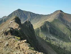
The same period also formed rocky ‘cwms’ or corries, hanging tributary valleys many of which have breath-taking waterfalls cascading over them, whilst the characteristic pinnacled knife edge ridges or arêtes like Crib Goch are found where two ‘cwms’ formed on either side of a mountain.
Text courtesy of Snowdonia National Park.
Find out more about the area and details of visiting on their website.
Related Links
Nearby Geosites
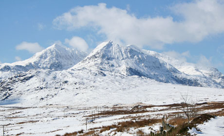
Images (top to bottom):- Snowdon in winter © Eifion (Source Wikimedia Commons) Creative Commons Attribution-NonCommercial-ShareAlike 2.0 Generic
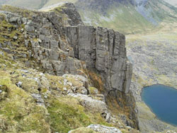
- Clogwyn Du'r Arddu, popular with climbers © Paul Glover (Source Geograph.org.uk) Creative Commons Attribution-ShareAlike 2.0 license.
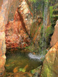
- Disused Copper mine exploiting mineral veins formed during volcanic activity © Mick Garratt (Source Geograph.org.uk) Creative Commons Attribution-ShareAlike 2.0 license.
- The knife-edge arête of Crib Goch © John Lynch (Source Geograph.org.uk) Creative Commons Attribution-ShareAlike 2.0 license.
![]()
October 13 - 21
Theme: 'Earth Science in our lives'