Cwm Idwal & Darwin’s Boulders
Snowdonia/Eryri, Wales

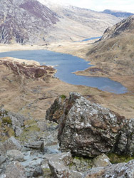
Cwm Idwal is a stunning hanging valley in the Glyderau Mountains of Snowdonia, 10 miles south-west of Bangor. In 1954 the area became the first Welsh National Nature Reserve, due to its geological, geomorphological, and botanical importance, and is also famous for its historical connection with Charles Darwin.
Fire and Water
The rocks of Cwm Idwal were formed over 400 million years ago, during the Ordovician time period. At this time, North Wales was largely underwater and experienced various periods of volcanism. The eruptions created dark basaltic and pale silica-rich rhyolitic rocks, some of which were deposited by highly explosive processes.
During explosive volcanism, ash and pumice* rain out from eruption clouds and hot flows of ash, gas and rock (pyroclastic density currents) can form and flow across land and into the sea. This type of volcanism often involves the eruption of huge amounts of magma, and can lead to subsidence of the earth’s surface and the formation of depressions known as ‘calderas’.
The rocks exposed at Cwm Idwal contain a number of deposits recording caldera-related explosive volcanism, in the Pitts Head Tuff Formation, the Lower Rhyolitic Tuff Formation, and the Bedded Pyroclastic Formation. These volcanic rocks, and the shelly marine sediments interbedded within them, record a dramatic history of the interaction between explosive caldera volcanism and an ancient ocean.
 The first rocks of the Cwm Idwal succession are sandstones and siltstones of the Cwm Eigiau Formation, seen in the crags west of Llyn Idwal. These sedimentary rocks were laid down along the shallow shoreline of a sea.
The Pitts Head Tuff Formation, the oldest of the volcanic units, overlies the Cwm Eigiau sediments and is well exposed in the lower western crags rising up across the ridge of Castell y Geifr to Y Garn. The Pitts Head Tuff is famous for containing distinctive streaky, flattened shapes that are aligned to form a banded appearance. These are pumice clasts that became compacted during deposition from a pyroclastic density current at very high temperatures, to form ‘welded tuff’.
The pyroclastic density current that formed the Pitts Head Tuff is believed to have at first travelled over land (at Moel Hebog to Moel yr Ogof) and then out into a shallow sea at Cwm Idwal; the wet sands and silts the flow travelled across were disturbed and became heated to release steam, seen as deformed rocks within the underlying Cym Eigiau Formation.
Following the eruptions that created the Pitts Head Tuff, a break in volcanism occurred. The sea became deeper as the area subsided. Sandstones deposited at this time are exposed in the ridges and crags immediately east of Llyn Ogwen.
The Lower Rhyolitic Tuff Formation records renewed volcanism at Cwm Idwal, and is a highly variable unit. It consists of ash tuffs, marine sediments, intrusive rhyolites (magma that did not make it to the surface but was later exposed by erosion), and pyroclastic breccias (consisting of large, angular rocks and pumice). These rocks can be seen in the prominent Idwal Slabs.
The uppermost unit, the Bedded Pyroclastic Formation, outcrops south-west of the Devil’s Kitchen and consists of volcanic-rich sediments that are greenish in colour and contain ripples formed by waves. These sediments are overlain by basaltic pillow lavas, which formed during underwater eruptions. When hot lava meets cold seawater, the outside of the lava chills quickly but the inside of the flow continues to expand; eventually the lobe breaks away and a new ‘pillow’ begins to form.
Darwin’s Boulders
Charles Darwin visited Cwm Idwal in 1831, and observed that the large, scattered boulders at Llyn Idwal (the lake) contained marine seashells. He realised that the rocks must have formed within an ancient ocean, and therefore had been later uplifted to the surface by forces within the Earth’s crust.
A Landscape Shaped by Ice
Darwin later returned to the area, and made a further observation- that the beautiful landscape of Cwm Idwal was shaped by glaciers, at a time when Wales was far colder than it is today. Glaciers are rivers of ice that move very slowly, and carve steep-sided valleys as they erode the rock beneath them. The larger the glacier, the deeper the valley it can erode; where small glaciers feed into a larger glacier system, small ‘hanging valleys’ are created high above the floor of the main valley. The word “Cwm” is Welsh for valley, and Cwm Idwal is a striking example of a glacial hanging valley. The heather-covered hummocky mounds observed at Cwm Idwal are further evidence of a glacial past- as the glaciers began to melt and retreat around 10 000 years ago, they laid down the rocky material within them to form hummocky ‘moraine’ deposits.
Text: Natasha Smith
Related Links:
Further Reading
Kokelaar and Koniger, 2000. Marine emplacement of welded ignimbrite: the Ordovician Pitts Head Tuff, North Wales. Journal of the Geological Society 157 (3) 517-536
Geological Conservation Review Volume 17: Caledonian Igneous Rocks of Great Britain (Chapter 6: Wales and the adjacent areas)Nearby Geosites
Images (top to bottom):
- Glacial Erratics in Cwm Idwal. The folded rocks of the Idwal Syncline can be seen in the cliffs behind (top left) © Tom Pennington (Source Geograph.org.uk) Creative Commons Attribution-ShareAlike 2.0 license.
- Cwm Idwal from Devil's Kitchen © Jeremy Bolwell (Source Geograph.org.uk) Creative Commons Attribution-ShareAlike 2.0 license.
![]()
October 13 - 21
Theme: 'Earth Science in our lives'