Pen y Fan
Brecon Beacons, Wales
The highest peak in the Brecon Beacons National Park and highest in Britain south of Snowdonia, Pen y Fan rises to a height of 886m or 2906 feet above sea level. It is formed from layer upon layer of Old Red Sandstone, a thick sequence of sandstones, mudstones and siltstones often referred to familiarly by geologists as 'the ORS'.
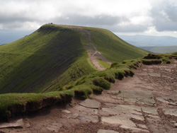
Few of the many thousands who come to visit each year will miss the ripples preserved in the exposed bedrock of this iconic mountain's near-flat triangular summit plateau. This summit area, like that of its similar, but slightly lower, near neighbour Corn Du which tops out at 873m or 2864 feet, is formed from the relatively erosion-resistant sandstones of the Plateau Beds. These rocks dating from around 370 million years ago are part of a thin late Devonian sequence which between them constitute the Upper ORS and which overlie a much thicker Lower ORS sequence. The Lower ORS coarsens upwards from the Raglan and St Maughans mudstones, which can be seen around Brecon, to the sandstones of the Senni and Brownstones formations which form the bulk of the local mountain massifs.
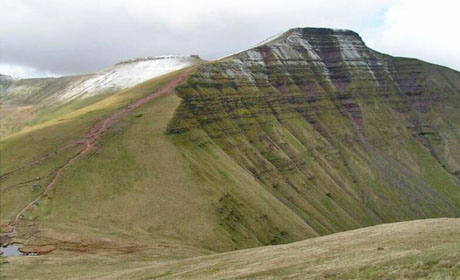
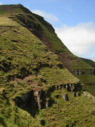
The precipitous northeastern face of Pen y Fan is seen to advantage by walkers following the path from Cribyn to the east. Here the alternating bands of red-brown sandstone and mudstone of the Brownstones Formation have been picked out by weathering and erosion. A final steepening marks the point at which, with the Middle ORS missing, the Upper ORS sits unconformably on the Lower ORS. This junction of the Plateau Beds with the Brownstones is in fact an angular unconformity though set at so slight an angle as not to be detectable here. It can however be discerned in views along the crest of the Carmarthen Fans in the west of the national park. In the east of the national park, the rocks of the Quartz Conglomerate Group are the equivalent of the Plateau Beds and form the rocky summit area of the Sugar Loaf which, like the central Beacons, also happens to be in the care of the National Trust.
 Typical of the Brownstones are the extensive sheets of sandstone which were laid down by seasonally flooding rivers crossing an otherwise semi-arid coastal plain. The alternation with the less-resistant mudstones and siltstones gives rise to the stepped landscape which is especially characteristic of the Black Mountains which are seen in eastward views from Pen y Fan. Broadly speaking the overlying Plateau Beds represent a marine transgression as sediment deposited by rivers was succeeded by sediments laid down in a coastal environment.
During the succession of Quaternary ice ages, glaciers formed repeatedly in and around these mountains though the twin summits are thought to have remained ice-free. Mounds of moraine which hem in the diminutive Llyn Cwm Llwch beneath the mountain's northern scarp derive from a small glacier which occupied this cirque during the final phase of glaciation around 12,000 years ago. Especially heavy rainfall events have on occasion caused numerous mudflows to cascade down these steeper slopes. In recent years these have been observed to occur particularly after hard winters which have opened up the soil structure. Such processes continue to erode these mountains as does the passage of the thousands of human feet each year. Visitors can help reduce their contribution to erosion by making use of the paths constructed from local materials by National Trust teams over many years.
Getting there
Most visitors ascend Pen y Fan from the National Trust car park at Pont ar Daf, just south of Storey Arms on the summit stretch of the nearby A470 (OS grid ref SN 987198, postcode LD3 8NL). Other routes are possible from National Trust car parks on the northern side of the Central Beacons or as part of a walking tour on the 97-mile Beacons Way which traverses these and other ORS summits in the National Park. Information on these routes and a range of geological publications about other aspects of Fforest Fawr Geopark are available at the National Park Visitor Centre (a.k.a. the Mountain Centre) at nearby Libanus.
Text courtesy of Alan Bowring, Forest Fawr Geoparc ('Great Forest Geopark')
Nominated by: FSC Margam @FSCMargam
Related Links
Nearby Geosites
Images (top to bottom):
- Pen y Fan from Cribyn © Dave.Dunford (Source Wikimedia Commons) Public Domain
- Rock layers picked out by erosion © Kenneth Yarham, source Geograph.org.uk, Creative Commons Attribution-ShareAlike 2.0 license.
- Sandstone exposed on summit © William, source Geograph.org.uk, Creative Commons Attribution-ShareAlike 2.0 license.
![]()
October 13 - 21
Theme: 'Earth Science in our lives'