Hadrian's Wall & the Great Whin Sill
Northumberland, England
Long lines of crags capped by Hadrian’s Wall (Figure 1), the Farne islands, the rocky hills topped by Lindisfarne (Figure 2), Bamburgh and Dunstanburgh (Figure 3) castles, the waterfalls of High Force (Figure 4) and Cauldron Snout, Holwick Scar (Figure 5) and Cronkley Fell (Figure 6), and the spectacular amphitheatre of High Cup Nick are all popular destinations for visitors to north east England.
All have one thing in common. All are expressions of one of the region’s, and one of the UK’s, most significant geological features – the Great Whin Sill.
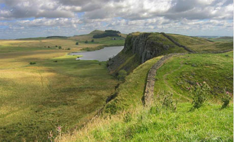
| Figure 1. Housesteads Crags Hadrian’s Wall here tops the prominent north-facing scarp of the Whin Sill. Although founded on Whin Sill dolerite, because this rock is so difficult to shape into regular blocks, the Roman builders used Carboniferous sandstones, quarried nearby, to build the wall. |
 |
The Great Whin Sill
So resistant to erosion is this dense hard black dolerite that almost wherever it reaches the surface it forms such distinctive landscape features. These were the features appreciated by the Roman engineers when planning the northern boundary of their empire, and by later rulers when seeking prominent and easily defended sites for their castles. Yet its importance in giving so much character to the region is not limited to its geological or landscape interest.
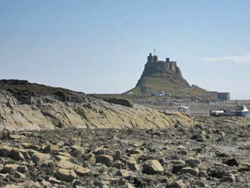 |
Figure 2. Lindisfarne Castle The castle stands on the prominent rocky knoll of the Holy Island Dyke, a member of the Whin Sill swarm of intrusions. |
Its sea cliffs (Figure 7) and the Farne Islands are internationally important as breeding sites for a variety of birds and grey seals. Soils derived from its weathering, and particular those formed from some of its associated rocks, support unique communities of some of Britain’s rarest and most beautiful plants.
In north east England the Whin Sill is to be seen almost everywhere, even far from its nearest outcrops. Its hard resistant qualities make it an ideal road-making material. Virtually every road in the region is surfaced with it. What then is this rock, and why is it so special?
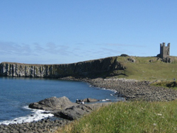
| Figure 3. Dunstanburgh Castle The ruined castle stands on a prominent headland formed by the Whin Sill. |
 |
The origins of the name
‘Whin’ is a term long-used in northern Britain for any hard black rock that was difficult to dress into shaped blocks. The word’s origins are obscure though two are often cited.
Firstly, it has been claimed that it may derive from the abundance of gorse bushes, also known locally as ‘whin’ bushes, on some of its outcrops in Northumberland. A second, and to my mind a much more interesting and wholly plausible explanation, is that it derives from the distinctive ‘whinn…..’ noise made when fragments of it are broken from larger blocks. Having worked on this rock over many years, during which time I have been on the receiving end of countless hits from sharp fragments of ‘whinn….’ as they have flown from beneath my hammer, I strongly support this as the true basis for the name!
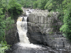 |
Figure 4. High Force,Teesdale The River Tees here cascades over the resistant ledge formed by the Whin Sill at England’s highest waterfall. Well-bedded shales and sandstones which overlie the Tynebottom Limestone (Lower Carboniferous) are conspicuous in the lower part of the fall. |
To a geologist ‘sill’ needs no explanation, yet how many appreciate its origins? Like ‘whin’ this is another long-established north country quarryman’s word for any more or less horizontal body of rock. Visiting geologists today are often surprised, and sometimes a little puzzled, to find sandstone beds in the Northern Pennines formally named as e.g. the Firestone Sill, the Grindstone Sill, the Slate Sills etc., but these are merely examples of the term’s traditional usage.
Long before geology emerged as a science, quarrymen in these parts knew that the sandstone of the Firestone Sill was good for making and lining hearths, that the gritty sandstones of the Grindstone Sill were well suited to grinding corn, and that the slabby sandstones of the Slate Sills provided ideal roofing material. To them the Whin Sill was simply another horizontal bed of distinctive rock – ‘whin’ - that was hard, black and difficult to shape.
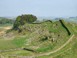
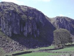
| Figure 5. Holwick Scars, Teesdale Vertical columnar jointing in the Whin Sill is prominent in these sombre crags on the southern side of the Tees valley. |
 |
Importance to research
Early in the 19th century pioneering geologists recognised that Northumbrian ‘whin stone’ was not part of the local sedimentary succession but, from its crystalline texture, was plainly an igneous rock. Originally it was supposed that it might be a lava, erupted during Carboniferous times. More careful examination revealed that the sedimentary rocks both below, and more crucially above it, had clearly experienced metamorphism by its heat and it became obvious that this was an intrusive rock, not a lava. Thus, not only was the true origin of the Whin Sill recognised, but geological science had a new term - ‘sill’. Here in north east England, the Whin Sill is the ‘type’ sill of geological science.
 |
Figure 6. Cronkley Fell, Teesdale The Whin Sill here forms the conspicuous flat-topped Cronkley Fell. Soils derived from metamorphosed limestones and shales on top of the sill, exposed on the summit, carry a rich variety of rare Arctic Alpine plant species, for which Teesdale is internationally famous. |
Geology across the region
Whereas a single sill is present over much of the region, in parts of Northumberland two or more leaves are known locally. The complex intrudes Carboniferous rocks ranging from the Border Group to the Middle Coal Measures. Component sills average around 30m in thickness, though in parts of the northern Pennines thickness of up to 90 m have been recorded.
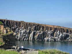
| Figure 7. Cullernose Point, south of Craster, Northumberland Well-developed columnar jointing in Whin Sill dolerite. These sea cliffs provide important nesting sites for sea birds. |
 |
The Whin sill is composed of quartz-dolerite, much of it medium- to fine-grained, though with very fine-grained tachylitic rocks adjacent to its chilled contacts and with some spectacular coarse-grained dolerite pegmatite bodies locally in its central parts (Figure 8). Vesicles, some with excellent examples of ropy flow structures reminiscent of pahoehoe lava, have been recorded in exposures in the Bamburgh and Lindisfarne areas. Well-developed columnar jointing is conspicuous in most exposures of the sill (Figures 5 and 7). Geochemical studies indicate that the sill’s petrographical affinities are dominantly tholeiitic, but geochemically transitional between alkaline and tholeiitic. It has been estimated that the volume of magma intruded as the complex comprises at least 215 km3, and probably very much more.
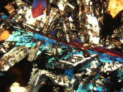 |
Figure 8. Thin section of Whin Sill pegmatite from Upper Teesdale, viewed under crossed polars Feather-like crystals of pyroxene (bright colours) are surrounded by plagioclase feldspar (shades of grey). Iron and titanium oxides are seen as black opaque areas. Field of view – 5mm across. |
Effects on the surrounding rocks
The extent of contact metamorphism is remarkably variable but reaches its maximum extent in Upper Teesdale where limestones for up to 30 m above and below the sill have been altered to a coarse-grained marble, known locally as ‘sugar limestone’.
Soils formed from this and other nearby contact rocks support an important assemblage of Arctic Alpine plant species, including the beautiful spring (Gentiana verna) (Figure 9) and the birds eye primrose (Primular farinosa) (Figure 10). Elsewhere, thermal metamorphic effects are commonly much less obvious.
|
Figure 9 |
Figure 10 |
|
 |
 |
As pebbles of typical Whin Sill dolerite are known from basal Permian conglomerates in the Vale of Eden, the complex was clearly emplaced and exposed to erosion during the time interval represented by the unconformity between the uppermost Carboniferous and lower Permian. Radiometric dates for the intrusion range from 301 to 294 million years ago.
Related Links
- Visit Hadrian's Wall
- The Hadrian's Wall trail
- The Rock Cycle (KS3): The Whin Sill
- Download a leaflet about the Whin Sill (from North Pennines Area of Outstanding Natural Beauty)
The Great Whin Sill at other Geosites
Images (top to bottom):
- Hadrian's Wall atop the Great Whin Sill © Michael Hanselmann (Source: Wikimedia Commons) Creative Commons Attribution-Share Alike 3.0 Unported License
- Figures 1-7 © Brian Young
- Figure 8 © British Geological Survey
- Figures 9-10 © J.Young
![]()
October 13 - 21
Theme: 'Earth Science in our lives'