Channel Tunnel
Straits of Dover, England/France
The Channel Tunnel is a 50.5-kilometre (31.4 mile) rail tunnel linking Folkestone, Kent, in the United Kingdom, with Coquelles, Pas-de-Calais, near Calais in northern France, beneath the English Channel at the Strait of Dover. At its lowest point, it is 75 m (250 ft) deep.
The tunnel comprises two 7.6m internal diameter running rail tunnels and a central 4.8m internal diameter vehicular service tunnel connected by cross passages. Each of the tunnels is just over 50 kms in length from portal to portal and this is one of the most significant engineering projects of the 20th Century. It links the UK to mainland Europe with some 100 million people within a 100 mile radius of the portals.
The UK portal is at Castle Hill, north of Folkestone, and the French portal is at Beussingue, near Sangette. Investigations and Design commenced in 1985 and Construction began in 1988. The scheme finally opened for rail traffic in 1994.
Undersea Section
The tunnels are located wherever possible in the most favourable tunnelling medium, the West Melbury Marly Chalk (formerly known as the Chalk Marl) towards the base of the Lower Chalk. This Marly Chalk is free from flints, generally has a very low permeability and is usually less fissured than the overlying Chalk strata.
The lowest member of the Lower Chalk is the Glauconitic Marl which in the undersea section was found to be a moderately strong, green glauconitic sandstone with low permeability. It has markedly different physical properties from both the overlying Marly Chalk and the underlying Gault Clay. The Glauconitic Marl was very easily recognisable both on the marine geophysical records and in the marine borehole cores, providing an excellent marker horizon during the site investigation surveys.
It was possible to correlate this horizon at the bottom of the Lower Chalk across the Channel, maximising the intense use of multichannel digital geophysical seismic surveys, with a limited number of additional, very expensive, deep marine boreholes drilled from offshore oil field jack-up rigs. Earlier boreholes were also tied in to the geophysical surveys.
Figure 1. Coloured geological section portal to portal
(Download larger version)

The UK seaward drive left the Kent coast at a depth of about 45m below sea bed following a slight eastward dip in the Chalk strata. The tunnels reach their lowest point at 115 m below sea surface level, approximately 13km offshore at a point where the rock cover is at its greatest, 75m.
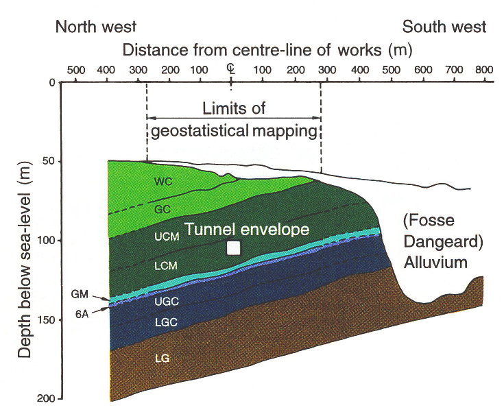
From this low point in the UK section the tunnels continue in the Marly Chalk and gently rise towards the mid-Channel position. Over this central section, the tunnels run relatively close to a major geological feature, the Fosse Dangeard, a massive buried valley formed by scouring of the sea bed to a depth of 85m during the Late Devensian.
The French tunnel drives left the coast at a depth of 35m below sea bed, remaining within the Marly Chalk wherever possible. However, due to geological folding, faulting and fracturing, the tunnelling machines had to be able to operate in closed mode in this more permeable ground.
| Figure 2. Cross section showing Fosse Dangeard geology and tunnels (Download larger version) |
 |
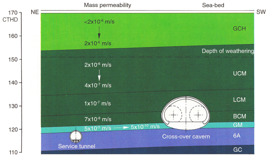
Crossing facilities between the two running tunnels are needed in the undersea section to facilitate maintenance and for operational reasons. The UK offshore crossover cavern is situated approximately 7km off the coast in an area of favourable geology with its invert in the Glauconitic Marl. The crown of the cavern is 35m below sea bed and it has an squashed elliptical shape some 15m high and 22m wide and some 165m long.
The cavern was formed in stages with side headings, crown, bench and invert sections using sprayed concrete temporary and permanent linings. At the time of excavation this was the largest undersea cavern built in the world, and represents a major technological feat.
(Download larger version)
The French crossover is located some 12km off the French coast in less favourable ground conditions. The chamber was constructed using a series of contiguous small diameter tunnels with a minimum height of 2m and has overall dimensions 180m long, 19m high and 25m wide.

|
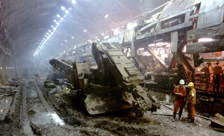
Figure 4. Running tunnel TBM in Crossover |
UK Land Works
The Tunnel reaches the UK coast at Shakespeare Cliff, to the west of Dover and close to a platform created on the foreshore in 1843 during construction of the London to Dover railway. An exploratory adit was driven from this platform during an earlier phase in 1974 and this was used as the main access for construction of the UK tunnelling works. The spoil from the works was used to extend the platform westwards and the area later formed the Samphire Hoe Nature Reserve.
| Figure 5. Shakespeare Cliff and Lower Shakespeare working site | 
|
The 9 km of tunnelling between Shakespeare Cliff and the portal at Castle Hill follows the Marly Chalk with the underlying Glauconitic Marl (1-2m thick) and the Gault Clay being encountered at Holywell Combe.
 |
Figure 6. UK portal at Castle Hill with Holywell Combe now crossed by the A20/M20 highway |
In all six major landslides were identified along the escarpment in the area, the major engineering challenge being to ensure the stability of the Castle Hill portal.
Holywell Combe is a Site of Special Scientific Interest and was known to contain a highly fossilised sequence of Late Glacial and Holocene deposits in the valley floor. Thus in 1987, prior to construction works, a series of multi-disciplinary investigations and rescue excavations were carried out. These studies provided a comprehensive history of the past 13,000 years of an English Chalkland valley.
Text courtesy of Bill Rankin & Ron Williams, of Mott MacDonald
(Both Authors were involved with the design and construction of the Channel Tunnel.)
Related Links
- How the tunnel was built (Eurotunnel infographic)
- Engineering Geology in action: pictures from the Victoria station upgrade
References
- The Channel Tunnel 1989 Conference organised by The Institution of Civil Engineers, London and The Societe des Ingenieurs et Scientifique de France, published by Thomas Telford
- Engineering Geology of the Channel Tunnel, 1996 published by Thomas Telford.
- Preece, RC Bridgland, DR 1999 Holywell Combe, Folkestone UK: a 13000 year history of an English Chalkland valley. Quaternary Science Reviews 18, 1075-1125.
![]()
October 13 - 21
Theme: 'Earth Science in our lives'