.jpg?h=351&w=347&la=en) Marking the launch of the new McKenzie Archive, Sue Bowler interviews the 1983 Wollaston medallist
Marking the launch of the new McKenzie Archive, Sue Bowler interviews the 1983 Wollaston medallist
“The reaction was astonishing. I went from being an unknown graduate student … to one of the people everybody invited to a conference and paid their way … before I had even the most junior position as an academic.”
Fifty years ago Dan McKenzie was among the handful of people, worldwide, who brought about the plate tectonics revolution. This new paradigm for understanding the Earth came about because of an explosion in the amount and quality of data, made possible by new technology – a process that continues in Earth sciences today.
Picture: Black and white photograph taken from a negative, showing Dan McKenzie standing in a river bed with mountains in the background, taken during an undergraduate field trip, [1960-1962]. The image may have been taken somewhere in Scotland, possibly in the North West Highlands North of Ullapool. McKenzie Archive.
Archive
McKenzie’s landmark 1967 paper with Robert Parker was the first to describe rigid plate movements, and was one of a flurry of publications in the late 1960s that demonstrated the power of plate tectonics to explain the evolution of the Earth’s surface. McKenzie has now donated his extensive archive to the Geological Society of London. His archive has been catalogued and can be searched online; the Society has also established a dedicated website for a wider public audience. McKenzie will give the William Smith Lecture in October this year, the highlight of a William Smith meeting centred on plate tectonics and how the ideas developed then and in the half century since continue to shape modern geosciences.
 Back in 1967, however, none of this could be anticipated. “I wondered for a long time”, remembers McKenzie, “whether I was going to be one of these scientists who has one really good idea when they’re in their twenties and that’s it.” He needn’t have worried: he has gone on to work extensively and successfully in fluid dynamics, continental tectonics, mantle dynamics, melt generation and planetary geology, among other fields.
Picture: Detail from figure showing a reconstruction of the Indian Ocean, 75 million years before present, used in the paper McKenzie, D & J G Sclater, "The evolution of the Indian Ocean since the late Cretaceous", 'Geophysical Journal of the Royal Astronomical Society', vol 24 (1971), pp 437-528. McKenzie Archive
He was elected a Fellow of the Royal Society in 1976, aged just 34; in 2011 he received their premier award, the Copley Medal. McKenzie has received honours and awards from around the world, including the Gold Medal of the Royal Astronomical Society in 1992 and the Crafoord Prize from the Royal Swedish Academy of Sciences in 2002. And he was in 1983 the youngest recipient of the Wollaston Medal for his career contribution to Earth sciences.
Scripps
In 1963 McKenzie started his PhD in the Department of Geodesy and Geophysics at Cambridge, winning while a research student a fellowship from King’s College that gave him the freedom to travel and pursue his own ideas. He headed for the United States, to 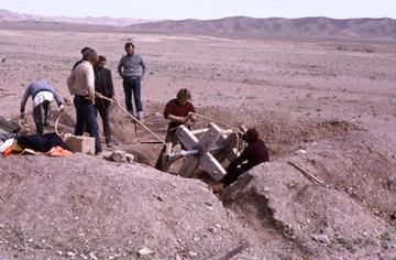 Scripps Institution of Oceanography at the University of California at San Diego, Lamont Geological Observatory at Columbia University, New York, and the California Institute of Technology in Pasadena, California, in turn. He also attended in 1966 a conference at the Goddard Space Science Laboratory in New York on ‘The History of the Earth’s Crust’. “It wasn’t really about the Earth’s crust at all”, says McKenzie. “It was all the new stuff from magnetic anomalies, earthquake mechanisms and it was quite clear then that the whole thing was essentially on.”
Picture: Photograph by Dan McKenzie, taken from 35mm slide, of a field project to install strain meters in qanats at Dasht-e-Piaz [Plain of Onions], c.200 km south of Mashad in north-east Iran. Image shows the field workers lowering a rope down the vertical shaft of a qanat to about 30m deep to access the horizontal tunnel at the base in which the strain meter was placed. The study trip resulted in the paper: King, G C P and R G Bilham, J W Campbell, D McKenzie & M Niazi, "Detection of elastic strainfields caused by fault creep events in Iran", 'Nature', vol 253 (1975), pp420-423. McKenzie Archive
Continental drift had never been taken seriously by most geophysicists; it was these new data from the oceans that changed minds and led to plate tectonics. Technology developed for submarine warfare during the Second World War led to accurate bathymetry, refined in the Cold War. Magnetic methods for tracking submarines picked up remanent magnetism in the rocks of the ocean floor; academic research began to use both methods, and to measure heat flow.
By the early 1960s, the mountainous mid-ocean ridges, with higher heat flow than their surrounding plains, were well-documented. In 1962 Harry Hess of Princeton University suggested that the ocean floor formed there and spread out on each side. In 1963 Cambridge geophysicists Fred Vine and Drum Matthews combined this idea with reversals of the Earth’s magnetic field to explain symmetrical stripes of normal and reversed rock magnetism on each side of ridges.
 Euler
Euler
In the 1950s the prospect of underground testing of nuclear weapons by hostile powers led to the US establishing a committee to discover how to detect such tests. The result was a standard seismometer, deployed worldwide in a linked network using the same protocols for testing and with a standardised response. The Worldwide Standardized Seismic Network (WWSSN) produced an immediate improvement in the accuracy of earthquake locations, showing that undersea earthquakes were very tightly clustered along what were later seen as plate boundaries.
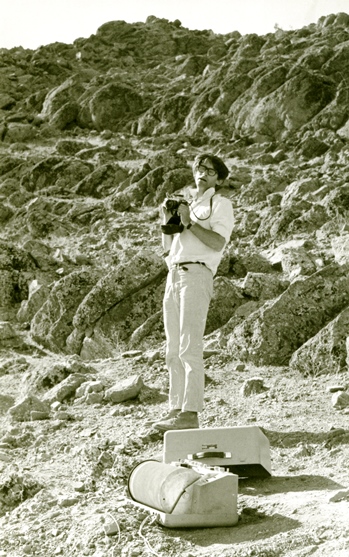
Picture: Black and white photograph showing Dan McKenzie standing in front of a MEG 800 seismometer, in the Zagros Mountains, Iran, [August] 1976.The research project overseen by McKenzie ran between August-October 1976. McKenzie travelled to Iran in August. The study trip resulted in the paper: Niazi, M and I Asudeh, G Ballard, J Jackson, G King & D McKenzie, "The depth of seismicity in the Kermanshah region of the Zagros Mountains (Iran)", 'Earth and Planetary Science Letters' vol 40 (1978), pp270-274. McKenzie Archive.
As well as location, the WWSSN gave information about the first movements and hence the mechanism of earthquakes, which corresponded to fault movements. This source of information on current Earth movements was essential for McKenzie’s formulation of plate tectonics.
“A lot of earthquakes had been studied in the North Pacific by, particularly, Father William Stauder in the Mid-West,” recalls McKenzie. “He actually listed the slip vectors of these earthquakes all around the North Pacific.” McKenzie examined the data around the north Pacific, and found large areas with no seismic activity – plates – surrounded by narrow bands with consistent movements – plate boundaries. He saw that the plates themselves were rigid and did not deform; their movement on the Earth could be simply described using Euler’s theorem, which McKenzie’s PhD supervisor Teddy Bullard had used to fit together the continents across the Atlantic (Bullard Everett and Smith, 1965). “So I then plotted that up … plotted is too fancy a word,” says McKenzie. “I took a National Geographic globe with its cap and drew with a marker pen lines on the globe and fiddled with the cap until I could see where the pole was for the motion of the Pacific [with respect] to North America.”
In 1967 McKenzie was at Scripps, as was Bob Parker who had written a mapping programme – HYPERMAP – that was ideal for presenting these ideas. Together they wrote a paper and posted it off to Nature. “I remember very clearly when I posted it. I thought ‘yep, that’s going to cause me to be elected to the Royal Society’” he says, “which was an arrogant thing to say but I was perfectly well aware of how important this was going to be when we did it”.
Lamont
Later in 1967, McKenzie moved to Lamont, where he discovered that Jason Morgan at Princeton had been working 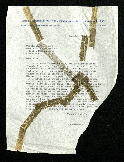 along very much the same lines. He also found out that Morgan had spoken about his work at the American Geophysical Union Spring Meeting that year, which McKenzie had attended. McKenzie wrote to Nature to try to delay publication of his paper, to no avail – and he tore up his letter to the Editor.
Picture: McKenzie’s letter to the Editor of Nature, requesting delay in publishing, torn up (and subsequently repaired) by Dan when the request was refused. LDGSL/1107/A/1/3 Letter to the Editor of Nature, 22 December 1967. McKenzie Archive
‘McKenzie and Parker’ was published in the final issue of Nature in 1967; Morgan published in 1968. “I was completely unaware, until I got to the East Coast, what had happened, and that was why I tried to delay the publication of the Nature paper,” says McKenzie. “Jason certainly has priority, but he did it in a completely different way. He didn’t use the earthquakes at all - he used the magnetic anomalies.”
McKenzie feels that this was one of those times when ideas leap out of the data, if you are looking at them in the right way. “As soon as I saw the slip vectors around the north Pacific and could describe that by a single pole, for me, that was it; I didn’t have to look at every other bit of the Earth. With Jason I think it was exactly the same. It was so obviously straightforward and the key piece of the whole story was that the plates were rigid.”
But McKenzie and Parker (1967) was not McKenzie’s first work on plate tectonics nor, arguably, his most significant. In 1966 he had returned to Cambridge to complete his PhD thesis, The Shape of the Earth. While waiting for his examination, he thought about ridges. Seafloor spreading was accepted, but the ridge was seen as part of a convection cell in the mantle, with the up-welling driving the two halves of the ocean apart. But McKenzie saw that the plates need not have any deep structure, they could be like ice floes moving apart, with magma welling up to fill the gap as a consequence of the movement. When next at Caltech, he modelled the process by computer, using heat flow and ocean floor elevation; his models matched the observations far better than those tying ridges to deep-seated convection (McKenzie, 1968).
Triple junctions
In the late 1960s, ideas were moving quickly. McKenzie together with Morgan published in 1969 a vector analysis of the evolution of triple junctions. And in 1968 he and John Sclater embarked on a project to survey the Indian Ocean, deriving the geological history of the ocean basin (McKenzie and Sclater 1971). McKenzie saw this extraordinarily successful result as a reason to move on. “I thought this was really just turning the handle … everything worked, which was really frustrating to me,” he says. “I then really stopped working on marine geology and geophysics, because I thought - gosh, we’re done.”
 He then went back to mantle convection. He applied what was becoming his trademark, of picking out the fundamental physical considerations and testing them in the simplest possible numerical models. “All the geophysicists are busy trying to model the Earth putting in every sort of complication you can, what I call kitchen sink modelling,” he says now. “I don’t think you learn anything. What I want to do is numerical experiments and see how these things behave.” His fluid dynamics work in the 1970s showed that mantle convection would produce a measureable gravity signal, testable by observation.
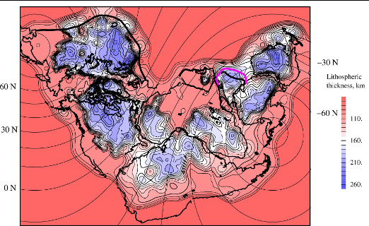
Picture: Figure from paper: McKenzie, D and M C Daly & K Priestley, "The lithospheric structure of Pangea", vol 43 (September 2015), pp783-786. McKenzie Archive
At the same time, he was working on the continents, where plate tectonics did not apply. “It was clear that the deformation was distributed, and you couldn’t really talk about plate tectonics in many of the areas on land,” he says. “But there were regions inside the continents which really didn’t have many earthquakes, which were moving rigidly.”
In 1967, while based at Lamont, he had started work on the area from the Azores to eastern Iran, which he thought large enough and seismically active enough sort out what was happening in the Mediterranean. The region’s politics mean that he moved to fieldwork in the Aegean; this is what led McKenzie to his 1978 model of extensional basins.
Model
 The McKenzie Model applies to basins such as the North Sea, formed by extension of continental crust and characterised by the accumulation of thick sedimentary deposits, all formed more or less at sea level, with the first extension by faulting. This was the pattern emerging from seismic exploration of the North Sea in the 1970s, but neither industry nor academic researchers could produce an adequate model of how it happened.
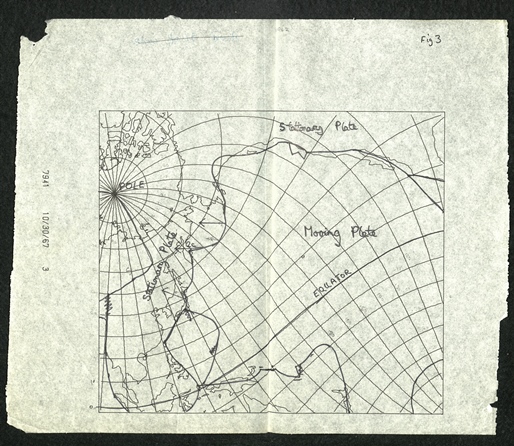
Picture: Map of Pacific from McKenzie and Parker 1967. LDGSL/1107/B/2/2/1 Original figure from McKenzie, D & R L Parker, "The North Pacific: an example of tectonics on a sphere", 'Nature' vol 216 (1967), pp1276-1280. McKenzie Archive
“What caused the penny to drop with me was that I’d known for a long time that the whole of the Aegean, the north and the south, from east to west, was all being stretched,” he said. “If you’re stretching something which is 400 km by 400 km, you can’t just be stretching the crust. You must be stretching the mantle.”
The McKenzie Model has its roots in the mid-ocean ridge modelling he had done a decade before: stretch the lithosphere, then track the thermal consequences. Fault-controlled subsidence is thus followed by thermal subsidence. “I wrote a short paper … after I’d moved to Lamont,” recounts McKenzie. “That was then picked up by their Industrial Associates before it was published and all the oil companies just like that said ‘this is correct, this is what we’re going to use’”. And they did, helped by the fact that computing power had advanced to the extent that the models could be written and run on desktop PCs.
McKenzie’s further work with Andrew Mackenzie of the University of Bristol demonstrated how this model could predict maturation within the source rocks of a basin. After some difficulty in publishing the paper – neither author had a track record in geochemistry – McKenzie and Mackenzie (1983) was awarded a prize as the best paper in organic geochemistry that year.
At the same time, McKenzie continued to think about the driving mechanisms of plate tectonics. “Plate tectonics works on the surface but clearly the Earth is not a rigid enterprise. So what went on below? It was clearly some form of thermal convection … but the rest of it was unknown.” Isotope geochemistry is a source of data on the mantle, and one that McKenzie went on to learn and use. This set him thinking about how a melt separated from its residue. To his surprise, this process was not covered in the literature.
“I thought well, this is a branch of fluid mechanics; I understand fluid mechanics; why don’t I sit down and see whether I can actually see how to set up this problem from the conservation laws of mass and energy?” He could, launching a new field in petrology with the novel fluid dynamics equations now called the McKenzie Equations. McKenzie went on to test them with data collected around Theistareykir in Iceland. The results answered petrological questions, but posed more.
“Yes the mantle is very well stirred, but it isn’t well mixed because the material doesn’t diffuse; it’s just like Brighton rock - it’s streaked,” he says. “In some way that we still don’t understand, the melt can be extracted from those streaks without interacting with any of the rest of it. How that works is still quite mysterious.”
.jpg?h=179&w=253&la=en) Diverse
Diverse
McKenzie’s career has covered diverse fields across Earth and planetary sciences. What they have in common is a focus on observations and the application of fundamental physical reasoning. Throughout his career, McKenzie has used, developed and adapted new technologies and sources of data. Earthquake seismology provided the key to understanding plate movements 50 years ago; now surface wave tomography, for example, makes possible reconstruction of continental lithosphere, such as Pangea, using surface wave tomograhy (McKenzie, Daly and Priestley 2015).
Picture: Dan McKenzie kneeling over photograph on ground, ‘Sept 18 Central Japan 1971, trying to see an active fault on a stereo pair of aerial photos by its effect on paddy field boundaries’. McKenzie Archive
For the future, McKenzie sees progress made possible by better technology, especially seismology. “Anyone who’s interested in any part of the interior of the Earth is in the end going to use full waveform inversion whether they’re interested in mantle convection, whether they’re interested in finding oil in sedimentary basins, whether they’re interested in the interior structure of the inner core – all of these things are going to be done with this technology in just the same way as all astronomers use big telescopes.” And he sees stronger links developing between Earth sciences and astronomy over planets around other stars, but regrets that most observations are going to be about planetary atmospheres – not planetary interiors – in the medium term.
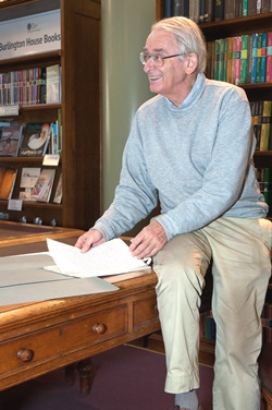
Picture: Professor Dan McKenzie, pictured in the Geological Society Library. Photo: Mark Wrigley. McKenzie Archive
 McKenzie’s success has come about because he has kept a sharp eye on the data and how it can illuminate the workings of the Earth. His physical insight has brought clarity to key aspects of how the Earth works, and, in turn, highlighted new questions. And, above all, he has stuck to the facts, in the lab, on the computer and in the field.
“You’ve got to be helped by making observations and decide whether you believe the observations or not on the basis of the observations themselves, not on the basis of theory. I feel that all very strongly now.”
Editor’s note