As we come to the end of ‘The Year of Mud’, Dave Greenwood * looks back to the Second World War when mud became a matter of life and death.
 In July 1944, a group of 22 men assembled for the first meeting of the Committee on Mud Crossing Performance by Tracked Armoured Vehicles (1), which soon became known by the more prosaic title of the ‘Mud Committee’. Its members included 13 Army officers (up to the rank of Brigadier), one person from the RAFVR and eight civilians. Two members were Geologists and Fellows of the Society. They were Captain (later Major) J L Farrington, officer commanding the Geological Section of the Inter-Service Topographical Department (ISTD) and Flight-Lieutenant (later Squadron Leader) J F Kirkaldy serving as a meteorologist in the Special Investigations Branch of the Air Ministry, also known as Department MO9 of the Meteorological Office (MO9), which dealt with the effect of weather on operations. Prior to WW II, Farrington was a Mining Geologist and Kirkaldy an academic at King’s College, London, and both returned to their civilian careers after the war.
Image: A WW II Churchill tank on Salisbury Plain in 1942.
Background
Trafficability or ‘Going’ maps were first used by the British Army in World War II during the North African campaign, based on local pre-war knowledge, published sources, air reconnaissance and reports received from the Long Range Desert Group (LRDG). The maps at a scale of 1:500 000 coded ground conditions under four headings: ‘good’, ‘fair’, ‘bad’ and ‘generally impassable’ and were highly effective. In early 1944, following the successful use of these maps, Lieutenant-Colonel D R Skinner, who later joined the Mud Committee, noted that tank trafficability in NW Europe would be influenced not only by the nature of the ground but also by the weather. He suggested that it would be useful if these effects could be forecast by scientific means and envisaged the preparation of ‘tank going maps’ similar to the soils maps used to guide site selection for aerodrome construction.
Skinner’s concern led to a special investigation by MO9 into the effects of the weather, and in particular rainfall, on the properties of soil, which was published in an internal report by F K Hare and J F Kirkaldy (2) in 1944. The report examined the relationship between soil and the underlying geology, the general physical and drainage properties of soil, the influence of topography, and the importance of the water table. It arrived at a simplified description for the balance between soil water content, run-off, evaporation and rainfall illustrated by an idealized model for the soil water cycle for an imaginary year in the northern hemisphere. The report does not contain any reference to the reason behind the study, but in a later paper Kirkaldy (3) stated that the object of the investigation had been tank trafficability.
Terms of Reference
Skinner’s concerns were included in the terms of reference of the Committee, which were that it should investigate the effect of soil characteristics on the performance of track-laying vehicles over soft mud or boggy ground in particular and to look at the effect of track, bogie wheel and suspension characteristics in order to improve the design of these components. They were also asked to look at the methods used for the calculation of ground pressure of such vehicles and initiate and supervise laboratory and field tests. The Committee began with a literature search including the relatively new discipline of Soil Mechanics. This was largely unsuccessful because of the difference between the needs of construction (large static vertical loads and top soil removed) and tank mobility (small dynamic vertical and horizontal loads applied to the top 300 mm of the land surface which is itself then disturbed). In spite of this the Committee felt Soil Mechanics had a part to play, especially with regard to methods of testing and identifying different types of soil, and that the principle of treating soil as an engineering material, capable of resisting applied stress but subject to failure, was sound and provided a way forward.
The Research Programme
In the absence of the information outlined above, the Committee embarked on its own research programme taking full account of the need for results that could be applied to current operations during the forthcoming winter and a long-term programme that could examine sinkage, adhesion and rolling resistance in relation to all possible variations in track design and ground conditions. A second area of interest was the problem of forecasting vehicle performance by the provision of soil maps and meteorological data. It was proposed to construct an artificial ‘soil bath’ at Chobham and to examine sites where trials could be carried out. The latter question was handed to a Soils Sub-committee that included both Farrington and Kirkaldy and they immediately set about looking at coastal areas where the ground would be refreshed with each incoming tide. These were first examined by an aerial survey, no doubt reflecting Farrington’s pre-war expertise in using this technique in mineral exploration, and then followed up by on-site visits.
Unfortunately by January 1945 none of the selected sites had proved suitable and programme was put into abeyance due to the imperatives of war. Instead the Committee turned its attention the use of an artificial ‘soil bath’ and to look for other inland sites for comparative tests. In the meantime a natural facility was made available at Albery Bottom on Chobham Common where trials were carried out under as near as possible the same conditions with tanks then ranked according to their performance, although it was noted that the skill of the driver had some influence on the results.
Soil Maps and On-site Advice
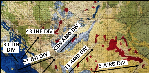 Image: J F Kirkaldy’s map of the Bocholt area used during the crossing of the Rhine in 1945 in relation to the plan of battle for Operation Plunder. The Rhine is located to the left of the map. Yellow: Sand and gravel; Striped Yellow: Fine or loamy sand; Green: Loam; Blue: Clay; Red: Peat; Striped Blue: Boulder Clay.
Little else survives from this period, however a copy of Kirkaldy’s contemporary soil map covering the crossing of the Rhine in March 1945 has been found. This shows that the simplified soil classification by ISTD was still in use and comparison with the plan of battle illustrates how well it was used (Fig 1). The choice of units to complete the breakout from the crossing was clearly influenced by the projected soil characteristics of the ground to the east of the Rhine, with an area marked as mainly loam or fine loamy sand to the north being secured by the infantry divisions whilst an area of mainly sandy gravel and boulder clay to the south was used for the main advance towards Bocholt by the armoured divisions. According to his Service Record, Kirkaldy continued in this advisory role up to the end of the war with a family letter placing him at Lüneburg in May 1945 (Mrs M Geeling pers. comm.), after which he returned to meteorological duties.
Neither Farrington nor Kirkaldy published much about their war-time work for the Mud Committee, Farrington restricting himself to references in an unpublished report on the history of the Geological Section of ISTD in 1946 (4) and Kirkaldy giving a brief summary of his work for MO9 in 1948 (3) without making reference to the 1944 report which presumably was still classified. Thus the reason for this reticence seems to have been one of security when, with the advent of the Cold War, tank performance in NW Europe again became a matter of strategic importance. As a result the matter was hardly discussed again in public until 1999, and even then only briefly (5). The Mud Committee itself continued with reduced manning until the middle of 1946 after which it was wound up, but its influence continued to be felt in the design of British tanks from the WW II Churchill all the way to the present day Challenger.
References
- GREENWOOD, D. A. 2012. Soil and water: research by the British Army’s Committee on Mud Crossing Performance of Tracked Armoured Fighting Vehicles in World War II. In ROSE, E. P. F. & MATHER, J. D. (eds) Military Aspects of Hydrogeology. Geological Society, London, Special Publications, 362, 161–186.
- HARE, F. K. & KIRKALDY, J. F. 1944. The Properties of Soils in N. W. Europe. Synoptic Division Technical Memorandum, 80, 1–18. Meteorological Office, Air Ministry, London.
- KIRKALDY, J. F. 1948. Soil and Weather. Weather, 3, 225–231.
- FARRINGTON, J. L. 1946. History of the Geological Section of the Inter-Services [sic] Topographical Department. Unpublished report. National Archives, Kew: catalogued as WO 402/378.
- OGORKIEWICZ, R. M. 2002. Armoured Fighting Vehicles. In: BUD, R. & GUMMETT, P. (eds) Cold War Hot Science: Applied Research in Britain’s Defence Laboratories, 1945–1990. NMSI Trading Ltd, London 117–145.
Acknowledgement : The author would like to thank Dr E P F Rose for his helpful comments on the original manuscript.
* Dave Greenwood is a retired Mining Geologist with an interest in the history of Geology.