Racoviteanu, A., Nicholson, L and Glasser, N., Debris-covered glaciers and related lakes: understanding the challenges. Geoscientist
30 (2), 24-25, 2020
https://doi.org/doi: 10.1144/geosci2020-070,
Download the pdf here
At a Geological Society meeting last year, scientists discussed the current state of research into debris covered glaciers and related hazards, and concerns related to the effects of climate change. Adina Racoviteanu, Lindsey Nicholson and Neil Glasser report.
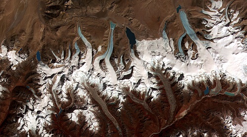 Image: Termini of the glaciers in the Bhutan-Himalaya. Glacial lakes have been rapidly forming on the surface of the debris-covered glaciers in this region during the last few decades. (NASA)
In many people’s imagination, glaciers in high mountains evoke dramatic, white icy landscapes. Some may not think of glaciers being covered by a mixture of debris made up of sand, gravel and rock, but this is the case with the majority of the glaciers of high Asia: tens of kilometres long expanses of debris covered ice and exposed ice cliffs and lakes. These so-called ‘debris-covered glaciers’ are harder to understand because of limited access and rugged terrain. They are a cause for concern due to rapid development and expansion of lakes at the glacier front. Sometimes, a rock fall or ice avalanche into the lake may cause the lake to break the dam and burst, triggering catastrophic flood events called “Glacier Lake Outburst Floods” (GLOFs). Given the possibility of an increase in this type of hazard due to climate change, it’s understandable that there is high concern among local communities. To address these concerns, we need better communication between scientists and local communities, as well as accurate and up-to-date debris cover evolution and lake hazard assessments schemes.
These topics were the subject of a recent Geological Society meeting, held in London from 2-4 September 2019, which brought together scientists in an informal, working group setting to discuss concerns about the climate impacts on debris-covered glaciers and related mountain hazards, and strategies for community engagement.
Mapping and monitoring of debris covered glaciers
In order to understand and monitor debris-covered glaciers and their associated hazards, it’s important to be able to map them accurately. The debris-covered glaciers working group discussed in detail the features and properties of the debris cover, as well as the remote sensing and field tools available to monitor it. A particular challenge in mapping these glaciers is posed by their rapidly changing surface features such as ice cliffs and supraglacial lakes. This group agreed that, even with the current advances in remote sensing tools and availability of high-resolution imagery, mapping the extent of debris cover on glaciers is not a straightforward task. New methods based on new satellite imagery and topographic data include analysing thermal data, radar interferometry, differencing of digital elevation models and shape detection. However, no single method can work by itself, and combining various methods often requires expert knowledge. As an outcome of these discussions, the working group has initiated an inter-comparison study of the different remote sensing methods and recommendations for best practice, in view of developing an automated, open-source tool in the future.
Deconstructing myths about GLOFs
A number of myths surround GLOFs, contributing to the uncertainty and concern amongst local communities. It’s often thought that the majority of glacier lakes in high mountain areas are dangerous, or that the growth of a lake necessarily increases its degree of hazard. Alarmist news stories often associate the outburst floods with climate change, whereas in reality climate is only one of the contributing factors. The GLOF working group focused on how we can estimate glacial lake outburst potential via a two stage assessment – first using remote sensing and topographic data at regional scale, followed by a site specific investigation requiring expert knowledge and higher resolution data at local scale. The aim of this working group is to develop a hazard assessment protocol as open-source tools that could be applied by non-specialists using freely accessible satellite imagery.
Challenges in capacity building and communication
If we are to improve understanding of debris-covered glaciers and their associated hazards among local communities, we need to establish and promote community-wide outreach. Capacity building initiatives targeting local academic and government institutions are currently supported by the new IGCP 672- UNESCO project ‘Himalayan Glaciers and risks to local communities.’ Launched in 2018, the project, led by A. Racoviteanu, focuses on developing methods for systematic monitoring of GLOF potential in the Himalaya using remote sensing, and disseminating them via training workshops for local institutions in India, Bhutan and Nepal. Smriti Basnett, Asian co-leader of the IGCP project, summarised the challenges of lack of funding and support from local government in past initiatives in India, and underlined the need for involving local stakeholders (state governments) in securing funds. She also recognised some specific regional challenges in border areas such as the states of Sikkim and Ladakh. Specialised training in glaciology alone is not enough – we need interdisciplinary, broader systems training which is long term, rather than the limited programmes funded externally.
During the meeting, Scott Watson (University of Leeds) reported on the ‘Walk the Talk’ initiative, held in December 2018 in the Khumbu region of Nepal, which brought together residents and scientists to discuss research, and was part of a wider initiative to engage communities and tourists. Plans are now underway to develop online resources – the website www.rockyglaciers.org and associated twitter account @rockyglaciers are already established. The science communication working group developed a basic set of advice and recommendations for scientists for engaging communities, based on our experience in rural communities in High Mountain Asia and in the Andes. Good research practices include setting up collaborations with local partners, spending time with the communities, establishing networks and promoting local outreach. Next steps include securing funding to expand initiatives such as Walk the Talk or the UNESCO project, in order to further engage with local researchers and local communities.
The organising committee thanks all the speakers and participants for their efforts and acknowledges the Geological Society for their support in hosting the workshop.
Authors:
Adina Racoviteanu, Aberystwyth University, UK
Lindsey Nicholson, Univ. of Innsbruck, Austria
Neil Glasser, Aberystwyth University, UK