Product has been added to the basket
Articles

Bruce Yardley appointed Chief Geologist

Bruce Yardley (Leeds University) has been appointed Chief Geologist by The Radioactive Waste Management Directorate (RWMD) of the Nuclear Decommissioning Authority (NDA).

Chartership news

Chartership Officer Bill Gaskarth reports on a projected new logo for use by CGeols, advice on applications and company training schemes

Climate Change Statement Addendum

The Society has published an addendum to 'Climate Change: Evidence from the Geological Record' (November 2010) taking account of new research

Cracking up in Lincolnshire

Oliver Pritchard, Stephen Hallett, and Timothy Farewell consider the role of soil science in maintaining the British 'evolved road'

Critical metals

Kathryn Goodenough* on a Society-sponsored hunt for the rare metals that underpin new technologies

Déja vu all over again

As Nina Morgan Discovers, the debate over HS2 is nothing new...

Done proud

Ted Nield hails the new refurbished Council Room as evidence that the Society is growing up

Earth Science Week 2014

Fellows - renew, vote for Council, and volunteer for Earth Science Week 2014!  Also - who is honoured in the Society's Awards and Medals 2014.

Fookes celebrated

Peter Fookes (Imperial College, London) celebrated at Society event in honour of Engineering Group Working Parties and their reports

Geology - poor relation?

When are University Earth Science departments going to shed their outmoded obsession with maths, physics and chemistry?

Nancy Tupholme

Nancy Tupholme, Librarian of the Society and the Royal Society, has died, reports Wendy Cawthorne.

Power, splendour and high camp

Ted Nield reviews the refurbishment of the Council Room, Burlington House

The Sir Archibald Geikie Archive at Haslemere Educational Museum

You can help the Haslemere Educational Museum to identify subjects in Sir Archibald Geikie's amazing field notebook sketches, writes John Betterton.

Top bananas

Who are the top 100 UK practising scientists?  The Science Council knows...

The end of the map?


GB3D

Martin Smith and Andy Howard* explain why moving away from the printed map to a digital 3D National Geological Model is a ‘coming of age’ for William Smith’s great vision

Geoscientist 22.02 March 2012

Picture: Perspective view of UK geology showing BGS 3D model under construction as a series of key surfaces and grid of cross-sections

Most countries have a ‘Geological Survey’. Though their roles vary considerably, they share a common purpose - to deliver geoscience knowledge that supports socioeconomic development, underpins research and provides authoritative, objective advice. The geological map has long been the main product that captures and communicates this geological knowledge; but this is now changing fundamentally in response to changing needs and new technologies.

Globally, in response to concerns (such as: living with natural hazards, environmental change, and security and sustainability of natural resources) many surveys are re-thinking their priorities for science and information delivery. In terms of geological mapping, for example, in 1996 the survey of the Netherlands was ’completed’, and the Dutch Survey (TNO) moved to constructing a national 3D geological model . Similarly, with the completion in 2011 of its 1:50,000 survey programme the French survey (BRGM) has moved to 3D representation, with the development of the Geological Reference System for France.

So what is happening at the British Geological Survey (BGS)? For more than a decade BGS has been preparing for a step-change. In 2012, it will wind up its systematic, map-based geological surveys of Great Britain and the production of lithoprinted geological map series, and move to a responsive programme with digital outputs. So - is this the end of the geological map as we know it? What will replace it?

Large infrastructure projects will benefit from the new 3D NGM

NEW DIMENSION

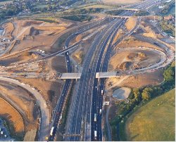
Picture: Large infrastructure projects will benefit from the new 3D NGM

Early geological maps of the UK, from William Smith onwards, were a response to economic need (coal, water, ores, building materials, transport infrastructure) to sustain the Industrial Revolution and military campaigns. However, like all good field geologists, William Smith had a well developed three- dimensional geological model in his mind. His 1815 map and cross-section represents the first national 3D geological model, communicated using best available technology - the printing press. For nearly two centuries the printed map and its derivatives have remained the signature output of the UK’s core geological survey knowledge-base.

But in today’s rapidly changing i- and e- world, geospatial applications, GPS and the Internet have made mapping on almost any imaginable theme instantly accessible online. The recently released iGeology smartphone app1 has put an entire UK map library’s worth of BGS digital maps into the pockets of the public. While this dataset is still communicated in 2D, software for modelling the form, properties and processes of the subsurface in three-dimensions is now available, affordable and used increasingly for geoscience applications, research and education.

This digital revolution also coincides with the present government’s intention to invest significantly in transport, energy and communications infrastructure. National Infrastructure Plan 20112 highlights several ambitious projects, including the recently approved ‘HS2’ high-speed rail link, which will all demand the best available data and visualisation of landscape and subsurface to aid design and construction, together with process models to forecast impacts from these developments on critical resources like groundwater, and vulnerable environments, like wetlands.

FUTURE PRIORITIES

Going digital releases us from the limitations of sheet-based mapping , allowing us to integrate data and interpretations acquired from a variety of projects that are more tailored to user priorities, including:
  • large, multi-disciplinary geoscience survey and modelling projects in conurbations and their catchments (e.g. Glasgow/Clyde and London/Thames projects, currently ongoing), focusing on the Quaternary, Anthropocene and shallow bedrock geology
  • responsive geological surveys that develop new partnerships with end-users and address needs of major infrastructure and energy projects including HS2, new-build power stations, major regeneration schemes and the energy and water grids
  • new, field-based investigations aimed at quantifying and modelling the physical and engineering properties of superficial deposits and rocks at sample, outcrop and basin resolutions, focusing on discontinuities, fabric and weathering and using new techniques in terrestrial LIDAR, shallow geophysics and remote sensing.
These surveys and observations will be embedded into a new, overarching 3D National Geological Model (NGM) of the UK. For the first time, this will provide us with the means to build and maintain a consistent, spatial knowledge base of the UK subsurface that is scale-independent and can be updated responsively as new data become available.

NATIONAL MODEL

So, what will this NGM look like? At regional to national scale it will be a seamless model that provides a geologically consistent framework for the Bedrock, Quaternary and Anthropocene deposits. In turn, this will host a range of other models of more varied content and scale: i.e., local and site-specific, much as the current 1:625,000 geological map embodies the 1:50,000 geological data. The models will use the same geological classification as the traditional geological map but will capture much more comprehensively the 3D understanding and interpretation of the survey geologist. The digital geological map, in various forms, will continue to be a key output of the NGM.

Models will not simply be used for visualisation but be queried as 3D information systems, using virtual boreholes, excavations and cross-sections to assist with subsurface problem -solving. As well as being successors to the geological map, these models will be capable of attribution with measured and interpolated physical, chemical and engineering properties. They will provide the medium for modelling the impacts of human use of subsurface space and resources, and will be ready to take their place within more ambitious models of the Earth System to help forecast and address the challenges of societal and environmental change. No doubt the technology of these 3D models would astound the early surveyors; but they would be very familiar to them in terms of 3D understanding.

We expect to release the first version of the bedrock national geological model this year, at a comparable resolution to the current 1:625,000 scale national geological map. Our aspiration is to store and deliver our best interpretation everywhere, though this will vary considerably in content and resolution across Great Britain, especially in the immediate future as existing digital maps and models are merged into the NGM.

In essence, the pace of technological change and evolving demand means that there will no longer be a single, ‘iconic’ output from the model like the printed geological map. Instead, models can be continuously updated and manipulated to display the geology from the users’ perspective and reflect currently available data. As new tools and technologies for querying, analysing and sharing the data become available, the outputs and use of the models will transform in ways we cannot foresee.

Subsurface Glasgow, showing main coal seams and shafts extending down below East Glasgow Picture: Subsurface Glasgow, showing main coal seams and shafts extending down below East Glasgow

FUSION

If we want our geological data to make a difference, and contribute to integrated Earth System models , we face a major challenge in how to share and fuse our spatially referenced information and knowledge with, for example, those of other mapping agencies, research institutions and regulatory bodies. One key issue, emphasised at a recent Model Fusion conference held at the Geological Society3, is to communicate confidence in our models and the uncertainties associated with them.

For the geologist traditionally trained to ‘bite the bullet’ and produce a single definitive and defensible interpretation, this represents a major cultural and intellectual challenge. This can be partly addressed through education and training, but perhaps most effectively by continuing professional development and working in partnerships with other scientists and users.

Conclusion

Our ability to represent the subsurface environment is radically changing. The future geological map, in digital form, will be just one of many outputs from a 3D dataset. However, the skills, experience and knowledge embodied in the scientists involved in interpreting and modelling this dataset remain fundamental. Geological models, like in William Smith’s day, will continue to require a geologist with core field skills to interpret and model the challenging complexities of the subsurface.

As the UK’s geological survey, BGS will continue, for the foreseeable future, to complete field investigations and surveys to upgrade the NGM. We will still produce printed maps for educational or leisure use, where demand is sufficient. Far from the ‘end’ for geological maps, as some might perceive, we believe this to be the ‘coming of age’ of the geological model that truly captures the visions and understanding of William Smith and successive generations of geologists, and will define the role and purpose of geological surveys for future decades.

Acknowledgments

The authors thank Steve Mathers and Diarmad Campbell for constructive comments and Jean-Marc Ryckebusch for assistance with diagrams. This article is published with permission of the Executive Director, BGS.

References

  1. BGS iGeology webpage: www.bgs.ac.uk/igeology/
  2. National Infrastructure Plan 2011 HM Treasury, November 2011: www.hm-treasury.gov.uk/national_infrastructure_plan2011.htm
  3. Model Fusion conference, Geological Society 28-29 November 2011: www.model-fusion.org/
* British Geological Survey