Icebergs drifting under the midnight sun, night-time polar bear watches and wading through frozen rivers are all part of the Greenland field experience, reports Anna Bidgood
Bidgood, A., Probing continental subduction in East Greenland.
Geoscientist 29 (5), 10-13, 2019
https://doi.org/10.1144/geosci2019-027;
Download the pdf here
Surrounding the settlement of Ittoqqortoormiit, at the mouth of Scoresby Sund in North-East Greenland, is the Liverpool Land Terrain—a geological terrain that records evidence of subduction to ultra-high pressures (depths of over 100km). Such ancient ‘ultra-high-pressure terrains’ are typically found exhumed within mountain belts and provide a direct record of a poorly understood process: the subduction of continental crust.
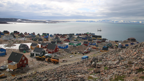 Left, Scoresby Sund settlement
Located in a steeply mountainous area within the Arctic Circle, Liverpool Land terrain is inaccessible even by the standards of ultra-high-pressure terrains and is therefore particularly understudied. The combination of excellent geology combined with a mountaineering challenge was part of the motivation for organising an Oxford University expedition to the region during the summer of 2018. We wanted to reconstruct the metamorphic and structural history of this geological unit and collect samples for petrological work, to archive with the geological survey of Denmark. Ultimately, we want to understand how buoyant continental crust, which typically resists subduction, can be forced to depths of over 100km beneath Earth’s surface.
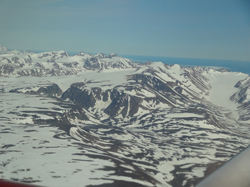 Right, Photo of the field area looking north from the plane. The deep incised valley is the Tvaerdal Valley and the snow-covered glacier on the right the Jaettadal.
A Glacial Landscape
The settlement of Ittoqqortoormiit is home to approximately 450 people and was originally a hunting settlement. The only permanent settlement in the region, it was founded in 1925 by the Danish explorer and administrator, Ejnar Mikkelsen, who saw an opportunity to re-colonise a rich hunting area (where the population had died out in the 1900’s) and, in the process, decrease the hunting-pressure farther south on Greenland’s east coast. The fjord system known as Scoresby Sund (named after the English whaler and ice-navigator, William Scoresby) is one of the largest and longest fjord systems in the world, with the longest fjord extending at least 350km inland. Indeed, recent research suggests that this fjord system may extend under the enveloping ice, right across Greenland to the west coast, thus effectively dividing this enormous Arctic island into two!
Our team consisted of two geologists from the University of Oxford (myself and Jamie Lucas), an arctic botanist and mountaineer (Nigel Bidgood), a geographer (Peter Shuttleworth) and mountaineer (Nils Devynck). Many of our team have visited Greenland before for mountaineering expeditions and geological fieldwork and are familiar with the kinds of challenges involved with working in large-scale glacial landscapes. Nevertheless, estimating the distances that can realistically be covered each day when trekking always proves difficult. As per any expedition, we modified and changed our plan on arrival into Greenland to account for weather, terrain and polar bears.
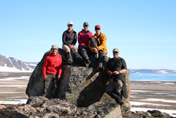 Left, The team above the braided glacial river plain running into the fjord below (credit: Peter Shuttleworth)
The journey
The boat journey from Constable Point across Hurry Inlet was relatively short and relied on my navigation skills using a 1:250,000 scale map with 100m contours, whilst trying not to get seasick or lose any maps to the wind. Luckily only one map was lost, and we were set down on the western side of the field area with a plan to backpack east onto the ‘plateau’, where we would be in an ideal position to move around the proposed research area.
On landing, we looked at the terrain sloping steeply to the east up to a high point of 700m with dismay. The steep, unstable glacial landscape was deeply incised by rivers that formed great canyons and ravines filled with hard-compacted snow and thick ice. Long, frozen lakes feed the rivers and miles of boulder fields provided no place to camp. We soon realised that tackling this terrain with 35kg backpacks was out of the question and instead embarked on a four-day detour, to approach our field area from the south and east.
Back-up plan
Our back-up plan turned out to be an amazing backpacking route. We were blessed with incredible views of the mountains and could take in the sheer vastness of Scoresby Sund. We followed the remarkable coastline complete with an abandoned Greenlandic hunting settlement (somewhat sadly named Kap Hope) and a hunters’ musk ox graveyard. As well as introducing us to the varied boulder geology and some interesting outcrops, the route took us along sandy beaches littered with icebergs and flanked by cliffs of snow.
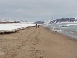 Right, The journey along the coast
Incised rivers outpoured to the fjord all the way along the coast, sometimes forming a small boulder-dammed lake at their mouth, allowing for an easy crossing. At other times, the 15m cliffs down to the river forced us to wade into the sea and cross the river mouth in the sea—an exhilarating experience. At the mouth of the glacial Jaetteelv River in the Jættadal Valley, we turned inland and painfully crossed a muddy (Triassic) bog where the difference between the solid and sinking ground, to this day, leaves me baffled.
At 70 degrees north on the east coast of Greenland, polar bears are a serious consideration. This is not a denning area, but it is a popular hunting ground for polar bears and humans alike, due to the huge fjord systems and abundant marine life. Each team member was woken twice a night to do two one-hour bear watches. This experience was made more pleasant by the midnight sun, which glowed from its hiding place behind the mountains. We opted for two one-hour watches, rather than a single two-hour one, due to the night hours being very cold indeed—I wore five layers including a down jacket and an extra, large down jacket of one of the other team members over the top of everything I owned! During the first night, many mist-enshrouded icebergs were blown into the fjord which, combined with the midnight sun, made the watch a truly magical experience.
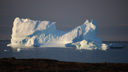 Left, Polar bear watch and icebergs in the midnight sun (credit: Peter Shuttleworth)
Complex geology
After our four-day detour, we arrived at the frozen Tværelv River, which runs down from the southernmost of the Tvaerdal lakes and marks the entrance to our field area. The terrain dramatically changed to either an unstable boulder field with a flora dominated by small, intensely-coloured arctic flowers and birch “trees” that peeped out from between boulders or small flush meadows at the base of steep sided, snow-covered mountains and periglacial landscapes. Access to the plateau every day meant crossing the boulders and rivers, which made for slow progress. Our ascent of Kronen (a 1140-m-high peak) took us up a steeply inclined boulder field onto a wide, gently sloping summit ridge covered in periglacial stone polygons. Over the next few days, we saw migmatites (of mafic and metasedimentary origin), eclogites (high pressure mafic rocks), gneisses (granitic origin) and peridotites (mostly dunites with purple chromium garnets).
Eastwards from our basecamp the terrain and geology changed as we headed into metasedimentary migmatites containing strongly metamorphosed marbles, amphibolites, and quartzites. To access these rocks, we had to cross a braided glacial river system, spanning about 1.5 km with over 10 to 20 channels depending on the time of day. The ice-cold water and strong current made crossing the channels more difficult than you would expect from a river of its size and proved rather painful when the blood rushed back to your feet!
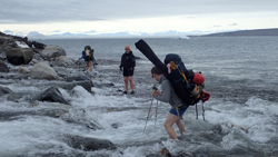 Right, Crossing the river in the fjord
A building point
The samples I collected cover a huge range of rock types, mirroring the similarly huge range of pressures and temperatures this terrain must have experienced in the past. The samples could provide some interesting information petrologically when studied under the microscope. The relationships between these rocks in the field provides crucial context for this type of study. Unfortunately, the limited time and difficult terrain meant that we were unable to study the contact between these rocks types in detail and we were also unable to access the northern end of the field area at all.
However, the preliminary results from this field season provide us with a good building point for future trips. We now know that backpacking in and out of the region is possible. Although, the extra equipment required for polar bear protection and the weight of the rock samples makes this a challenge—one that pragmatically may lead to the use of helicopter transfers into and out of the study area next time!
Acknowledgements
This expedition was made possible due to the generous support from the Mike Coward Fund of the Geological Society of London, the Gino Watkins Memorial trust, The Oxford University Exploration Club and the Irvine Fund, for which we are hugely thankful.
Affiliation
Anna Bidgood is a PhD student at Oxford University and was a 2018 recipient of the Geological Society of London’s Mike Coward Fund; e-mail:
[email protected]