 Ramues Gallois and Geoff Davis* show how geologists and engineers have faced up to the challenging geology of the famous resort.
The Dorset coastal town of Lyme Regis can trace its origin back over 1000 years to a fishing village adjacent to the mouth of the River Lim. There has been a church there since 1145, on a headland protected from the effects of marine erosion by a low cliff fronted by ledges of Jurassic Blue Lias limestone.
Left: Cobb Gate tea room and B&B c.1945 before the construction of the Cobb Gate sea wall and Phase 1 engineering works. The building now houses a chip shop. By permission, Lyme Regis Museum.
The town has a history of building protective sea walls and groynes that dates back to medieval times. On the west side of the town, the 13th Century Cobb wall protecting the harbour is thought to be the oldest breakwater of its type in the country. The area between the harbour and the village was prone to landslide and rapid marine erosion and was not built on until the Regency fashion for seaside resorts caused the town to expand. As a result, by the early 20th Century parts of the town were built on, or closely adjacent to, landslides of various ages, and the coastal zone faced the double threat of marine erosion and the reactivation of old landslips.
 Resort
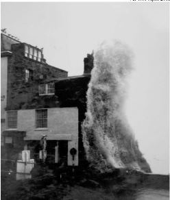
Right: View W. from Marine Parade towards the harbour area showing a landslide in Langmoor and Lister Gardens in seaward-dipping Charmouth Mudstone on 14 February 14 1962. Foreground: the De la Beche stone jetty (1820) was an unsuccessful attempt to retain the beach deposits to protect the foot of the sea wall. Photographed the day after the event by Maureen Keats, Curator, Dorset County Museum.
In addition to its popularity as a resort, Lyme Regis is of particular importance to geoscientists for its contribution to the early development of geology as a science, and for the continuing value of its cliff and foreshore exposures. Mary Anning (below, left), a skilled palaeontologist and not just a collector, and another one-time resident Henry Thomas de la Beche, founder of the British Geological Survey, were among those who made major contributions based on observations at Lyme.
 Left: Copy (1850) by B J M Donne of an oil painting of Mary Anning and her pet dog Tray made by an unknown artist in 1842. The copy includes much more geological detail than the original. The view is ESE towards Golden Cap and Thorncombe Beacon. Mary stands on Blue Lias Bed 35 beneath Church Cliffs. R: tabular projecting beds: limestones in Blue Lias. L: E-dipping limestone ledges in Blue Lias intertidal outcrop - prolific source of early Jurassic vertebrate remains. The new sea wall (Phase 4) was designed to reflect storm waves to keep this area sediment-free.
The geological importance of the cliff and foreshore exposures adjacent to the town is reflected in the designation of Lyme Regis as a principal 'gateway' town for the East Devon-Dorset Coast World Heritage Site (the ‘Jurassic Coast’), and in their designation as Geological Conservation Review (GCR) sites for Lower Jurassic Stratigraphy, Fossil Fishes, Fossil Reptiles, and Coastal Geomorphology.
The geology of Lyme Regis and adjacent areas has been known since the early 19th Century, when De la Beche (1826) provided the first complete descriptions of the lithological and palaeontological successions. Much of the town is built on mudstones and limestones of the early Jurassic Blue Lias and Charmouth Mudstone Formations (Lias Group) unconformably overlain by the Cretaceous Gault and Upper Greensand Formations in the higher parts of the town. Thin (<10cm thick) beds of smectite-rich mudstone in the Charmouth Mudstone act as bedding-failure surfaces that give rise to landslides within and on either side of the town.
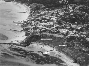 Right: Aerofilms oblique aerial view of the SW end of Church Cliffs (1925) showing erosional embayment between E. Jetty and St Michael's Church. It was reported that c.27 m of Church Cliffs had been lost between 1803 and 1833 due to marine erosion and the removal of limestone from cliffs and intertidal outcrops for building. The discovery of human bones on the beach led to a ban on stone-working, so that by the late 19th Century it was again partially protected from erosion by a natural apron of fallen blocks of Blue Lias. Courtesy, Lyme Regis Museum.
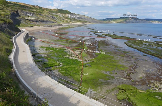
The Gault outcrops give rise to extensive rotational and translational landslides. On the east side of the town, the Black Ven landslide is an old, probably Pleistocene, complex of interacting coastal landslides that are in the process of being reactivated as a result of a combination of historical quarrying, earlier sea-defence works and marine erosion. Large-scale failures have occurred in the Cretaceous rocks at less than 10-year intervals during the past 60 years, almost always during or shortly after prolonged periods of rain. In contrast, large-scale failures have been less frequent in the Charmouth Mudstone and have been restricted to areas where a low (< 1.5°) seaward dip has resulted in bedding-plane-initiated failures.
 Planning
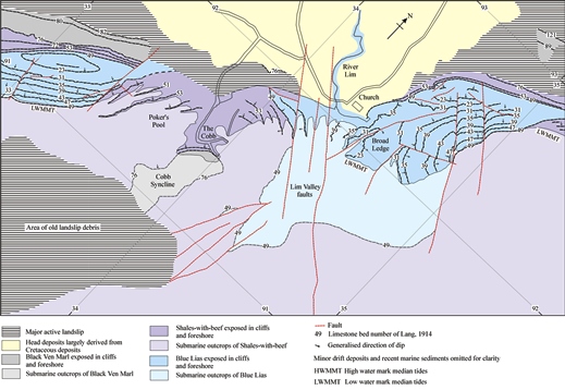
Map, left: Geological sketch-map of Lyme Regis and the area covered by the Phases 1 to 4 remedial engineering works. A combination of field surveys, numerous cored boreholes and seismic-reflection survey showed that the geological structure was more complex than had been thought.
Various remedial works have been carried out since Victorian times, including the use of groynes, sea walls and rock armour to protect the developments along the sea front, and drainage works in areas prone to landslide. None of these was lastingly successful. The prospect of possible higher annual rainfall and more frequent storms as a result of global warming suggests that the natural threats to the town are more likely to increase than to decrease.
The problem of erosion and instability along the seafront has been exacerbated by man-made changes to the natural coastline. The most obvious example was the Victorian and early 20th Century quarrying of the protective limestone ledges for cement-manufacture and building stone. Workings at the foot of Church Cliffs, at the eastern end of the town, eventually endangered the headland that had been the focus of the original Lyme Regis settlement.
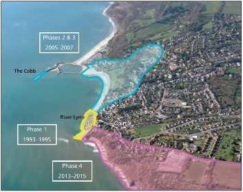
Right: Phases 1 to 4 of the remedial engineering works completed: they will ensure that the town and its access routes will remain stable for at least the next 60 years.
Changes to the shape and height of the Cobb wall interfered with the west-to-east longshore drift and at times starved the beaches of shingle. This, in turn, probably contributed to the reactivation of the sea-front landslides and the Black Ven landslide complex on the eastern edge of the town, partly by removing the toe weights of old slips, and partly by allowing increased marine erosion.
It was therefore by no means obvious what the best solution might be at Lyme Regis. Piecemeal protection of existing sea walls would not only detract from the town’s natural charm and damage the geological exposures, but it could also change the beach regimes and reactivate dormant landslides. The financial, legal and planning implications of any works could obviously be serious.
Research
 In 1985, West Dorset District Council (WDDC) in its role as coast-protection authority initiated engineering, hydrological, geomorphological and geological research to obtain the data necessary to enable long-term engineering solutions to be designed that would remove the long-term risks associated with the town.
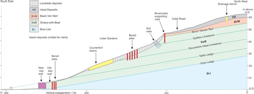
Left: The seaward-dipping mudstones underlying the landslides in Langmoor and Lister gardens in the town centre were stabilised using a combination of bored piles, soil nails and drainage works in conjunction with a new, more substantial sea wall at the foot of the slope to prevent marine erosion of the relatively soft Shales-with-Beef.
Site-investigation of large coastal sites involving unstable ground and active marine erosion, as at Lyme Regis, is commonly prohibitively expensive to carry out by drilling/trenching methods alone. However, such sites are amenable to the use of interactive multidisciplinary surveys that can provide a wealth of detailed geological information at low cost. The works commissioned by WDDC included: large-scale, colour aerial photography of the cliff and intertidal areas; bathymetric, seismic-reflection and sidescan-sonar surveys of the intertidal and the subtidal areas fronting and adjacent to the town; a programme of trial pits and continuously cored boreholes, and the installation of borehole instrumentation to monitor groundwater pressures and slope movements within the town itself.
Large-scale (1 to 1000) geological maps were made of the intertidal area fronting and adjacent to the town, using a combination of site surveys, orthographically rectified aerial photographs and GPS measurements. Taken together, these investigations provided the stratigraphical and structural data needed to design new sea walls and to identify the specific horizons in the Jurassic and Cretaceous succession that fail and give rise to the coastal landslides.
Town centre: Phases 1 - 3
A combination of engineering works in the intertidal area the stabilisation of the adjacent inland landslides between 1993 and 2007 ensured that the long history of sea-wall breaches and damaging landslides was brought to an end. In Phase 1, the most pressing problem of an unstable sea wall in danger of being breached by the sea - and taking the theatre, the museum and hotels and shops with it - was resolved by building new sea walls. 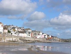
Right, above: View NE across Lyme Regis beach prior to construction of the Phase 2 seawall and replenishment of the beach, November 2005. Note patchy distribution of beach deposits, the exposed damaged wooden groynes, and temporary emplacement of rock armour to protect the parking area for excavating equipment. The De la Beche jetty (arrowed) remains relatively intact although it had been repaired from time to time.
Right, below: Same view, June 2014. Beach huts (middle, left) are standing on old sea wall. The new sea wall is concealed beneath an artificially emplaced protective beach made up of 75,000 tonnes of flint/chert gravel dredged from south of the Isle of Wight, and 35,000 tonnes of Tertiary sand imported from Esquay-sur-Seulles, Normandy. 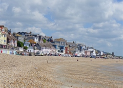
Left, below: Fragments (red) of the 5.6m-long ichthyosaur Temnodontosaurus platydon (Conybeare) recovered during Phase 2 works, superimposed on a drawing of an almost complete specimen found at Lyme in 1835 (from Hawkins, 1840. The Book of the Great Sea Dragons). Inserts: part of the vertebrae of the new specimen prior to cleaning and assembly, and part of its left hind paddle. The front skull was collected from debris thrown out from new sea wall excavation. Fortunately, most of the animal was preserved seaward of the wall, where remaining bones were retrieved by local specialists Paddy Howe and Peter Langham from additional, expressly-made excavations.
During Ph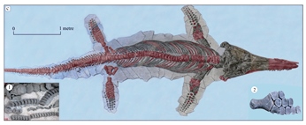 ase 2, two hundred boreholes drilled in the gardens, most of which were total-gamma-ray logged, showed that the principal failure surface was in seaward-dipping Charmouth Mudstone, four to seven metres below ground level, and provided details of fault-related lateral variations in the stratigraphy that had not previously been recorded.
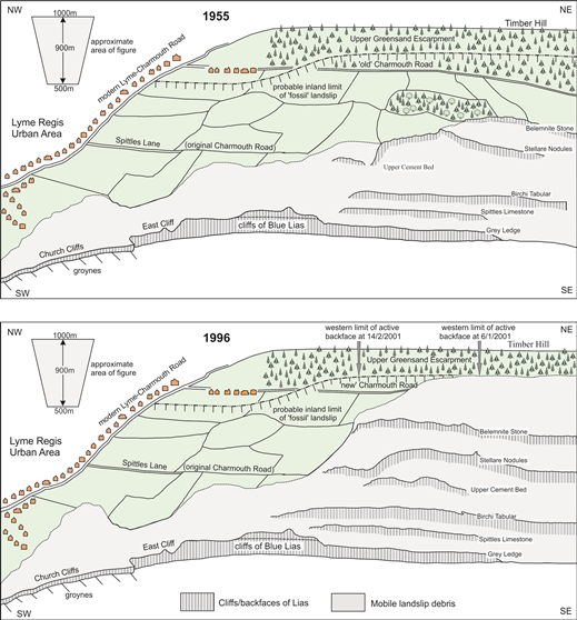
Right: Sketch diagrams of the W. part of the Black Ven-Spittles landslide complex showing how the topographically higher (Cretaceous) part expanded westwards between 1955 and 1996 and caused the lower (Jurassic) part to expand in the same direction. Topographical surveys have shown that this westerly extension has mostly occurred within the last 100 years.
 Although the intertidal area does not fall in the WHS, the geology was considered to be sufficiently important for WDDC to pay for Mr Paddy Howe, a Lyme Regis Museum palaeontologist, to monitor the debris from the excavations and to collect a representative selection of fossils and any scientifically important specimens. The most significant find was a largely complete ichthyosaur which is now on display at the museum.
The completed works provided the town with newly landscaped ornamental gardens, the opportunity to develop the sea-front area and a stable sandy beach, all of which have greatly increased the attractiveness of the town for residents and tourists.
Church Cliffs: Phase 4
The construction of a new sea wall and the landslide-stabilisation works on the east side of Lyme Regis (2012-15) marked the culmination of over 20 years of multidisciplinary studies. These had shown that the landslide activity had significantly increased in the 20th Century, probably due to a change to a warmer, wetter climate. The threat to the town was dramatically demonstrated in 2008 when c. 500,000 tonnes of mudstone collapsed and brought active landslides to within 100m of the urban area.
The remedial works were designed to ensure that the works could be carried out without damage to the World Heritage Site, GCR sites and sensitive biological habitats in the adjacent active-landslide area. Particular attention was paid to the positions and thicknesses of the limestone beds in the Blue Lias on which the footings for the new sea wall were to be founded. The Blue Lias successions exposed on either side of the town were measured to determine the degree to which individual limestone beds were laterally variable. This enabled a sea-wall foundation to be designed that would resist being undermined by marine erosion for at least 60 years, without the need for protective rock armour and/or beach replenishment, and would preserve the geological exposures.
Complex
 Left: Oblique aerial view of the 8 May 2008 landslide 36 hours after the event. View east: the western end of the landslide is <100m from the new sea wall and built-up area. © Maritime and Coastguard Agency.
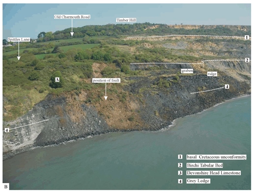
The geological structure of the Lyme Regis area revealed by the investigations proved to be more complex than that shown in the published literature. What had previously been supposed to be a gently undulating easterly dip in the Blue Lias Formation in the central part of the town proved to be a seaward plunging, fault-bounded syncline that brings the full thickness of the weak Shales-with-Beef Member mudstones down to sea level in that area. In addition, 30 faults were identified in an area that had previously been considered to have few. Almost all of these have apparent throws of less than two metres, but they have a marked effect on the dips of the strata in the blocks between the faults, and on the outcrop patterns on the foreshore. This, in turn, has an effect on the shape of coastline and the offshore topography, and on the susceptibility of the cliffs and coastal slopes to instability. The design of the remedial works was therefore dependent on a detailed understanding of the local succession and the stratigraphical positions of the landslide failure-surfaces.
Concerns, expressed at the design stage, that the works would destroy or make inaccessible some unique part of the Jurassic stratigraphical succession, proved unfounded. Not only were the engineering works designed to avoid damage to the geological value of the site, most unusually for such works, some features were included to enhance the geological interest.
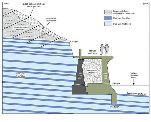
Right: Sketch section normal to Church Cliffs showing the relationship of the geology to the construction details of the 1956 and new sea walls.
The opportunity to replace a boulder-strewn rock pavement on the east side of the town with a sheltered, south-facing sandy beach was declined in favour of bare rock-ledges for the benefit of geologists. How often does that happen? Since the completion of the sea wall (July 2014) the intertidal area fronting it has been almost entirely sediment-free, with the result that the geology is currently better exposed than ever before. In addition, the new sea wall has provided easier and safer access to the geology of the intertidal area and East Cliff for educational groups and fossil collectors of all ages.
The collaboration of the geologists and engineers over more than 25 years proved of great benefit to both disciplines. It enabled engineers to prepare far more detailed ground models than is usually possible at the site-investigation stage, and to use these to produce the most cost-effective remedial solutions that will guarantee the safety of the town for the foreseeable future. Geology gained a better understanding of the stratigraphy of local Lias and Cretaceous rocks, of tectonic structure and its influence on coastal erosion, and of the mechanisms of some of the largest active landslides in Europe.
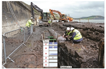
Below, left: Geological section along the seawall footings trench, showing the founding level of the new seawall. Each bay was founded on one of the thicker tabular limestone beds that had been shown, from a comparison of the successions exposed in East Cliff and the intertidal outcrops, to be laterally persistent.
 Suggested further reading
- Brunsden, D, 2002. Geomorphological roulette for engineers and planners: some insights into an old game. Quarterly Journal of Engineering Geology and Hydrogeology, v. 35, p. 101-142.
- Gallois R W, 2016. Geological investigations for coastal protection and landslide remedial works at Lyme Regis, Dorset, UK. Geoscience in South-West England, v 14, p. 1-11.
- Gallois R W and G M Davis G M 2001. Saving Lyme Regis from the sea: recent geological investigations at Lyme Regis, Dorset. Geoscience in south-west England, v. 10, p.183-189.
- Moore R, Stannard M, Davis G M and Browning N 2017. Stabilising Lyme Regis-a strategic approach. Civil Engineering, v. 170, p. 63-70.
Authors
- Ramues Gallois, Gallois Geological Consultancy E: Ramues Gallois
- Geoff Davis, engineering geologist
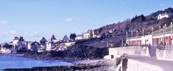
Left: View NE from the new seawall 25 February 2016, showing part of the extensive bare-rock platform that has become exposed since the completion of the wall.
Right: New sea walls were built up against the 18
th Century wall and provided a new promenade, hidden beneath which are storm-water tanks to hold polluted rain
water, a sewage treatment works and a pumping station.