As the Society develops its 100 geosites project, Rob Butler* looks at some of these islands’ great outcrops.
I well remember my first residential field trip: day one – among the Permian breccias at Oddicombe, Devon, picking through the detritus of the Variscan Orogeny. We had been directed by trip leader, Mike Coward, to ‘find pieces of ophiolite’. It was a crazy challenge, picking over pebbles – how would you know if a chunk of basalt came from former sea-floor? Pretty much everything was slate and limestone anyway. But it filled me with an enthusiasm for British geology that remains to this day, some 36 years later.
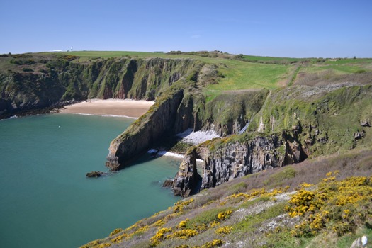
Image: Skrinkle Haven Pembrokeshire – a great location to examine the marine transgression during the late Devonian that inundated a swathe of the Old Red Sandstone continental environment.
Since then I’ve had the immense privilege to research in some truly brilliant field locations, and visited many others around the World. But there’s something special about British outcrop geology. Perhaps it's the exceptional variety that has inspired me and many other geologists over the centuries. As the Society began it search for 100 top geosites – with the list set to appear during October’s Earth Science Week, I got to thinking – what makes a truly great outcrop?
PLAYFAIR
Top of most people’s list, perhaps even of world outcrops, comes Siccar Point – a rather anonymous corner of the Berwickshire coast were it not for the work of James Hutton and his publicist – John Playfair. There are many other stratigraphic sites of importance in Britain but Siccar Pont stands out not only for historical precedence but also because of its architectural simplicity - part of the site has been replicated by casting in the American Museum of Natural History.
 Gazing away from the headland itself, with gently inclined Devonian red beds and the steeply-dipping Silurian turbidites, helps us to “upscale” – the term used by some to express the concept of taking local observations and visualising their impact on a scale beyond the immediate. Zooming into the contact itself reveals fragments of the underlying turbidite sandstones trapped in hollows and crevices passing up into continental sandstones, which talk to Earth processes and ancient landscape evolution.
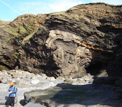
Image: With folds like this – why go to the Alps? Broadhaven’s structures in the far west of Pembrokeshire.
For some, great outcrops must be large. A list of great global stratigraphic sites must include the Grand Canyon: nowhere in Britain is there such a remorseless demonstration of the law of superposition. We rely on unconformities, such as Siccar Point, to tell stories of deep time. Non-geologists might find it perplexing that such narratives speak of the missing, rather than the present – the lost stratigraphy and the deductions of tectonics and denudation rather than the dynamic landforms themselves. And there are many greater stratigraphic omissions in Britain – such as the two billion year gap caught between the base of the Applecross Formation of the Torridonian and the late Archaean gneisses of the Lewisian’s Central Block in Assynt.
My personal favourite British unconformity for getting up close and personal with ancient landscape processes is up on the north Sutherland coast, at the tiny fishing village of Portskerra. The contact undulates, picking out low hills within the Caledonian mountain belt. Fragments of the metamorphic Moine rocks form screes on the hill slopes that grade out into fluvial sandstones. Small, compared with the Grand Canyon, but perfectly formed.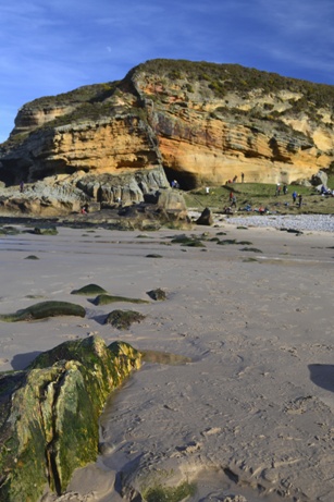
Image: Clashach - getting to grips with fault zone processes and reservoir properties at Clashach Cove, Moray
So, size isn’t everything. For tectonic folk like me, perhaps the most dramatic global location is the Alpine Fault of New Zealand. Ocean is juxtaposed against 3000m peaks along an active thrust – mountain building in action. But the processes that shape these mountains – mutually focusing tectonics and meteorology, serve also to continuously bury and re-excavate the Alpine Fault Zone itself. While the surface processes are exciting - the outcrops themselves are often deeply disappointing. For great fault zones, Britain’s long-dead structures such as the Outer Isles Fault on the Uists, or the Mesozoic structures that creep onshore around Durness, in Sutherland are better places to see the products of slip and shear.
FOOTPRINTS
Or try Clashach Cove on the Moray coast - perhaps best known for its rather spectacular dune sandstones and the early reptilian tracks, uncovered by quarrying on the cliff-top. These dune sandstones are excellent outcrop analogues, perhaps the best in Britain, for showing non-geologists what a conventional hydrocarbon reservoir can look like. But the normal fault and its associated deformation bands, perhaps only bettered by examples in Utah, hint at the complexities of exploiting oil and gas from structurally complex reservoirs. Structural geologists now use the site to discuss with reservoir engineers about how these features and their impact on permeability structure in the subsurface might be predicted. Gazing across the Moray Firth to the platforms and wind turbines of the Beatrice field give such discussions special relevance. Likewise the relationships and fracture patterns in the Old Red Sandstone and its basement at Portskerra have inspired discussions of subsurface geology pertinent to the Clair field, out in the Atlantic, west of Shetland.
 Britain has dozens, perhaps hundreds, of important sites for the history of geology. The key places are listed in the great Geoconservation Review. But for me, few qualify as great outcrops. Away from Siccar Point’s storm-swept crags (image, left), other examples of unconformities described by Hutton have fallen beneath vegetation, left to rot. Likewise it is hard to be inspired by a pile of grey, lichen-covered slate hidden under a thicket of brambles – even if it once yielded a particularly critical graptolite to the diligence of a 19th Century natural scientist.
Perhaps as a community we have tended to tell our outcrop stories through stratigraphy, rather than Earth processes. By all means keep the classic palaeo-biological and stratigraphic sites protected – especially from collectors. For me, great outcrops are those that have great architecture – show the relationships between rock units and give our imaginations some tantalising glimpses at the processes that put them together. It’s about form and structure – be it sedimentary, igneous or tectonic in origin.
MOINE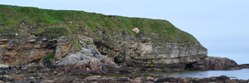
Image: The denuding Caledonian mountain belt – frozen in time. The unconformity at the base of the Old Red Sandstone (Devonian) at Portskerra, Sutherland.
So what makes UK and Ireland’s outcrops so great? Certainly there are some stunning large outcrops and geological landscapes, from the inner architecture of the Tertiary volcanic centres and their lavas on Skye to the mountainsides of structures in the Moine Thrust Belt. And certainly upland landscapes and coasts tell stories of Quaternary climate change and glaciation. Yet these can all be upstaged by global examples. It’s not their size – it is their human scale that makes British outcrops so special. They can be appreciated immediately and accessibly - as if laid out in a gallery. They serve to inspire and educate current and future geoscientists. And the really great exhibits tend to lie along our coast.
British coastal geology is second to none, from the huge sea cliffs and remote beaches of the Scottish islands to the popular tourist beaches of SW Wales and SW England. For me, these are the outcrops that define the quality of our geosites. It’s perhaps no coincidence that the UK geology’s two totemic World Heritage Sites, the Giant’s Causeway and the Jurassic Coast, are both beside the sea.
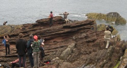
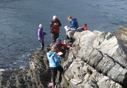 Image: Debating the relationships between deformation and intrusion in the Moine at Portvasgo, Sutherland.
With Scotland’s Land Reform Act and the opening of the Welsh Coast Path in 2012, many of these great locations can be accessed - tide, surf and the occasional steep scramble permitting. You would think that with the Marine and Coastal Areas Act (2009), England would be following suit, delivering access to the rest of the shoreline. But implementation has been painfully slow, hampered by some commercial lobby groups. Even with improved access rights, some of our outcrops are threatened by coastal defence schemes, exacerbated by last winter’s storms.
So we cannot take our outcrop heritage for granted – and we certainly should celebrate its diversity and importance, not just for the history of our science but for its continued use as a training resource for future geoscientists, and a showcase for inspiring others to understand Earth processes.
-
Editor writes: To see the list as it builds and to contribute a geosite, visit www.geolsoc.org.uk/100geosites. All submitted geosites must be within the UK and Ireland.
*Rob Butler is Professor of Tectonics at the University of Aberdeen and chair of the Society’s Geoconservation Committee.