Geologist and science writer Nina Morgan muses on the best methods of presentation
It's one thing to have a breakthrough idea, and quite another to find the best way to make it known. For the pioneering 19
th Century geologists, reading papers at scientific societies, which were often then circulated in the form of long and wordy books and articles, were the standard methods. But soon the realisation struck that maps, cross-sections and diagrams could be more effective. It could be argued that William Smith [1769 - 1839] kicked off this new communications trend in 1799 with his pioneering large scale geological map of the area around Bath. He later consolidated his lead with his wonderfully coloured 1815 Geological Map of England and Wales.
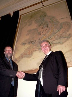
Picture, left: Mr Nigel Press and Dr Richard Fortey FRS (President) unveiling the restored Smith geological map at a reception at Burlington House on February 1, 2007. Nigel Press (NP Satellite Mapping) generously paid for the restoration and reframing of the Smith map)
But Smith was not the first geologist to recognise the usefulness of diagrams and cross- sections for explaining the origin of geological features. Another exponent of this technique was the Derbyshire geologist, White Watson [1760 – 1835]. As the geologist Trevor Ford [1925 – 2017], an expert on the Peak District in Derbyshire and champion of White Watson noted: "White Watson should be remembered for having provided a foundation of stratigraphical science in Derbyshire comparable to William Smith's earlier work around Bath".
Bakewell-based
Watson, was born at Whiteley Wood Hall near Sheffield, but lived for most of his life in Bakewell, Derbyshire. His uncle ran a small marble mill and shop in Ashford-in-the-Water, and from an early age Watson enjoyed visiting quarries and collecting fossils and minerals to keep the shop supplied. His uncle retired to Bakewell and in 1774 White joined him there. After his uncle died the mill was sold, but White, nothing if not enterprising, went on in 1825 to advertise on his business card as one who:
'executes monuments, tombs etc., gives lessons in geology and mineralogy and furnishes collections, affords information to antiquaries and amusement to Botanists'
He went on to set up a museum-shop, where his fossil and mineral collections were open to view for a small charge, and gave lectures on geology – usually at five shillings per head. He was a prolific collector and built up fossil and mineral collections, (sometimes of up to 500 specimens) for sale. He also earned an income by drawing profiles, either in ink or as marble inlays.
Watson appears never to have strayed more than 25 miles from his base in Bakewell, and as a result got to know the local geology very well. His published sections in his 1811 book, The Strata of Derbyshire (to give it its short title!), were among the first reasonably accurate geological sections to appear in Britain.
Set in stone
Although he drew a sketch map of the limestone districts of Derbyshire in around 1820 and an innovative circular diagram to illustrate the stratigraphic correlations in Derbyshire in c. 1825, paper, it seems, was not Watson's preferred medium for disseminating knowledge about geology. Instead, he turned to stone. His most famous – and beautiful – ‘publications’ take the form of cross sections presented as inlaid stone tablets. In these marble-backed plaques the strata consisted of inlaid pieces of the actual stones they were designed to represent.
His first tablet, illustrating 'A Section of a Mountain in Derbyshire', was made probably made around 1785. He went on to create more than 100 others, some illustrating geological processes such as volcanism, and others showing cross-sections of the geology in different parts of Derbyshire.
Great minds
Publications accompanying these early sections demonstrate that Watson was familiar with William Smith's principle of strata being characterised by certain fossils. But although Smith and Watson were near contemporaries, and Smith travelled widely through England, there is no evidence that the two ever met. Nevertheless, they shared a number of personality traits. Both enjoyed writing poetry and were full of good ideas for furthering and presenting the understanding of geology. Both were full of money-making schemes and were very hard workers in a number of different fields of enterprise. And both were also perpetually short of money, and often had to solicit loans from relatives or employers to continue their work.
The evidence from their archives reveals the reason why. When it came to money management and keeping accounts, both were abysmal failures!
Acknowledgements
Inspiration for this vignette comes from a meeting to celebrate the life of Trevor Ford, held in Buxton in June 2018. Sources for this text include: White Watson and his Geological Sections by Trevor Ford, Proc. Geol. Assoc. 71, pt 4, 1960, pp 349 – 363; The tablets of White Watson by Trevor Ford, Geology Today 14, no. 1, 1998, pp. 21 – 25; and The Strata of Derbyshire by White Watson, first published in 1811. I am also grateful to the collections managers at the Oxford University Museum of Natural History and the Derby Museum for images and information about the tablets in their collections.
* Nina Morgan is a geologist and science writer based near Oxford. Her latest book, The Geology of Oxford Gravestones, is available via www.gravestonegeology.uk