Andy Farrant and Tony Cooper* tell the inside story of the media frenzy following the spate of ‘sinkholes’ this winter.
 The winter of 2013-14 will be remembered for seemingly incessant rain and flooding, particularly in the Somerset Levels and across southeast England. Records from the UK Meteorological Office show that this winter was one of the most exceptional periods of winter rainfall in at least 248 years for England and Wales – possibly the most. For south-east and central southern England, over 492mm of rain fell - 238% of the average and beating the previous (1915) record of 437.1mm.
Picture: A collapsed denehole at Rainham Mark Grammar School, Gillingham in Kent. The collapse occurred where chalk had been mined for agricultural purposes during medieval times. Bricks in the base of the hole suggest that this feature may once have been capped with a brick arch. The base of the soil is marked by several small clay-filled dissolution pipes, creating a very irregular rock-head. Photo P Witney, ©BGS/NERC.
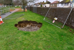
However, not only flooding made the headlines. During three weeks in late February/early March, over 25 ‘sinkholes’ opened up across southern Britain (compared to half a dozen at most in a normal year). “Terrifying holes that are opening up all over Britain” reported the Daily Mail while The Sun proclaimed “Pits of despair. First rain, now Brits suffer sinkhole hell”.
INUNDATED
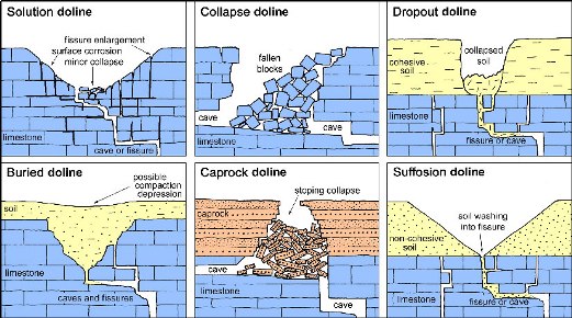 Image: Types of natural sinkhole.
In turn, the British Geological Survey (BGS) was also inundated - by media requests for information, as well as by enquiries from concerned homeowners. While sinkholes are not uncommon in the UK, it was unusual to have so many collapses happening so close together in time. So why was this?
The term ‘sinkhole’ has come to encompass a whole range of unrelated processes that result in the collapse of the ground. In a strict geological sense, it refers to a natural surface depression caused by dissolution of soluble rocks at depth. Other more local names are often used; for example, ‘shakehole’ or ‘swallow hole’ is typical in northern England while ‘swallet’ is common in parts of the southwest. More academic literature, especially in Europe, tends to use the term ‘doline’, which is derived from the Slovene ‘dolina’ meaning valley or plain.
However, many of the recent ‘sinkholes’ reported in the media were not natural geological phenomenon at all, but related to the collapse of artificial cavities or to the failure of materials capping mine shafts or wells. These should be termed ‘collapse subsidence’, ‘crown-holes’ or ‘mine entrance collapse’. Others were related to burst water mains and pressurised sewers, or simply compaction of loose fill. But for public use, ‘sinkhole’ means all these.
SOLUBLE ROCKS
Natural sinkholes (in the strict sense of the word) are caused by the dissolution of soluble rocks at depth. These include limestone, dolomite, chalk, gypsum and halite. Evaporites, predominantly halite and gypsum are by far the most prone to dissolution. Carbonate rocks are less soluble, although this largely depends on rock purity,  while the solubility of dolomite is typically lower than that of pure limestones. Sinkholes occur in all these lithologies. How and where they form depends on bedrock geology (lithology, bedding and structure), the presence, type and thickness of superficial cover, and local factors such as drainage and topography.
Picture: Seventy catastrophic dropout sinkholes caused in 1985 by a burst water main in solifluction deposits over raised beach deposits on Chalk at Littleheath Road, Fontwell, Sussex (© Sealand Aerial Photography Ltd, Chichester, reproduced under licence). This clearly demonstrates an anthropogenic trigger causing the collapse of natural, normally stable cavities in bedrock.
Six main genetic types of sinkhole were defined by Culshaw and Waltham1, three of which involve subsidence of overlying deposits (rocks, granular soils or cohesive soils). Cap-rock sinkholes tend to be the largest and most spectacular. Culpepper’s Dish (Dorset) is a good example2. Here Paleogene sand and clay has subsided into the underlying Chalk, creating a depression over 80m across and 20m deep. Other very large cap-rock sinkholes lie scattered beneath the uplands around the north crop of the South Wales coalfield. Localised collapses in the extensive cave systems that riddle the Carboniferous limestones have propagated though overlying sandstone to the surface. The removal of the collapse debris by underground streams has allowed these sinkholes to continue to enlarge, allowing them to grow, rather than become choked with their own debris. Some of the resulting breccia pipes are over 60m deep.
However, many of these are relict features. Contrary to popular belief, the collapse of cave systems to produce either a collapse or a cap-rock sinkhole is relatively rare. At the risk of ruining several action-movie plots, most limestone caves are actually pretty stable over 100,000-year timescales. Indeed, some caves in the UK are over 700,000 years old. Caves in gypsum or halite are the exception. In these rocks dissolution occurs far more rapidly, sufficient to be noticeable over human life-spans. In Ripon, dissolution of Permian gypsum at depth has created voids that have then migrated up through the overburden to cause subsidence at the surface, sometimes with catastrophic results as happed in Magdalen's Close, Ripon, North Yorkshire on 17 February.
SUFFUSION & DROPOUT
 Picture: Irregular rockheadBricks in the base of the hole (Deneham - see above) suggest that this feature may once have been capped with a brick arch. The base of the soil is marked by several small clay-filled dissolution pipes, creating a very irregular rock-head. Photo P Witney, ©BGS/NERC.
Suffusion and dropout sinkholes are more common and form in superficial deposits overlying the soluble rock, typically limestone. Suffusion sinkholes occur where sediment is gradually washed down into solutionally enlarged fissures in the limestone below, causing gradual subsidence. Dropout failures form similarly, but in more cohesive soils able to bridge voids until they become unsupportable, resulting in sudden failure and collapse. It is these unexpected events which often make headlines.
Thousands of suffusion sinkholes dot the limestone outcrops of the Yorkshire Dales where Devensian glacial till has been washed into bedrock fissures. In southeast England, similar features occur on the Chalk. Where the Chalk is covered by a thin cover of clay or sand (usually the Clay-with-Flints, but also river terrace deposits, glacial till, or locally the Thanet Sand3), acidic drainage can gradually dissolve out the Chalk beneath, creating dissolution pipes up to 10m deep. Normally they gradually become infilled with sediment as they form, so rarely contain voids and are generally stable.
Some sinkholes are caused by erosion of weak unconsolidated material by flowing water. Loose material can removed by a process called ‘soil piping’, creating large voids within the sediment. One of the most spectacular examples is the collapse that occurred in May 2010 in Guatemala City. Here cavities developed in weak unconsolidated volcanic deposits following a tropical storm. These then collapsed, creating a shaft approximately 100m deep and 20m wide. Smaller examples occur in the UK on thick soils and in upland peat bogs.
MINE COLLAPSE
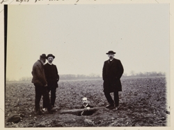 Picture: Descending a Denehole at Hangman's Wood, West Thurrock c. 1909. Shafts associated with deneholes are often capped and forgotten about until the collapse a century later. Photograph P805291 from the Geologists Association 'Carreck Archive'.
Many so-called ‘sinkholes’, particularly those in southeast England are really due to the collapse of old shafts or mines. The UK is peppered with man-made underground cavities including mines, wells, tunnels, cellars and store-rooms (e.g. in central Nottingham), culverts, and drains. When these collapse they can cause subsidence, as happened in December 2013 near Foolow (Derbyshire) when old mine workings failed spectacularly.
Most of the recent collapses in southern England have been associated with old chalk workings, for example at High Wycombe and Hemel Hempstead. Historically, chalk was often dug for agricultural purposes, chiefly to lime acidic soils or in some instances to obtain flint. Rather than transport chalk from distant outcrops, it was often easier to sink a shaft. The resulting cavity, known as a ‘denehole’, generally comprised a number of small excavated chambers entered by a vertical shaft typically around 20m deep. The top of the shaft was usually capped or blocked and then forgotten.
Chalk was also used as an ingredient for making bricks, either to change the colour or to counteract shrinkage. As brickworks were normally sited on clay outcrops (usually the Clay-with-Flints, Reading Formation or London Clay) shafts were dug to reach the Chalk. This explains the common association between former brick-pits and ‘sinkhole’ events. In some instances, a combination of natural and anthropogenic factors conspires to cause subsidence. Chalk mines sometimes intersect sediment-infilled dissolution pipes, leaving the sediment above unsupported and prone to collapse. Old Chalk wells are also implicated.
TRIGGERS
It is important here to distinguish between what causes a cavity to form, and what triggers collapse. Most subsidence events are trigger

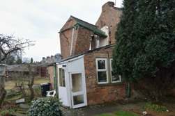
ed by water. Heavy rain or surface flooding, such as that experienced this winter, can initiate the collapse of normally stable cavities (especially those in superficial deposits) or cause shaft-caps to fail. This happens in several ways. The additional weight of wet soil, floodwater or saturated superficial deposits can increase the load to a critical level. Alternatively, increased water flow can flush out or compact sediments infilling a cavity. Water can also reduce the strength of material capping shafts or old wells. Bricks in the base of a collapsed denehole at Rainham Mark Grammar School, in Gillingham, Kent suggest that this feature may once have been capped with a brick arch that failed (pictures above). Prolonged winter rainfall or individual extreme rainfall events both have the same impact. Anthropogenic water-related sinkhole triggers include leaking drainage pipes, burst water mains, irrigation or even the act of emptying a swimming pool.
Picture: Soluble rock types and their distribution in the Great Britain based on BGS 1:625,000 scale Bedrock Geology map of the UK. ©BGS/NERC.
In some parts of the world, drought or groundwater abstraction can cause sinkholes by changing the level of the water-table. This removes the buoyant support water provides to a cavity, and so lead to collapse. Construction and development are also potential triggers, either by modifying surface drainage or altering loads imposed on ground without adequate support.
WHERE?
Areas prone to sinkhole formation occur throughout the UK, though natural sinkholes show strong association with underlying geology. Most sinkholes occur in areas underlain by Carboniferous limestones (the Mendips, parts of Wales, Peak District, and northern Pennines, including the Yorkshire Dales). Fortunately many of these are upland areas away from urban centres. A few occur in Devonian limestone outcrops in Devon and on the Jurassic limestone outcrops of the Cotswolds, Lincolnshire and the North York Moors. The Chalk is also susceptible, especially where covered by thin clay and sand deposits (the 'Clay-with Flints' and Paleogene strata), notably in parts of Dorset, Hampshire, the Chilterns, around Norwich, and Kent. In Scotland, sinkholes are generally rare except in parts of Assynt, Appin and Skye.
The most sinkhole-prone area in the UK is the Permian gypsum outcrop of north-east England between Doncaster and Darlington, particularly around Ripon. At least 30 major collapses have occurred in the last 150 years, some of which have affected property and infrastructure. This is because gypsum is far more soluble than limestone, and thus dissolves more rapidly.
Sinkholes also occur over salt deposits, especially where brine has been extracted as in parts of Cheshire, making it difficult to separate naturally formed sinkholes from those created by humans. Thus anthropogenic cavities are also linked to geology, as well as land-use and settlement patterns. The Chalk outcrop in Kent and in parts of the Chilterns is especially susceptible, being areas where deneholes, shallow mines and water wells are common. Other former mining areas such as Derbyshire, the northern Pennines, the Mendips, North Wales and southwest England are also susceptible to mine shaft collapse.
KARST HAZARD
 Picture: House partially collapsed at 26 Magdalen's Close, Ripon, North Yorkshire due to sinkhole formation over Permian gypsum in the Edlington Formation. The sinkhole affected the southern part of the house and adjacent greenhouse and measured 11m from north to south and 15m from east to west. The collapse occurred about 17.30 on Monday 17 February 2014. Photo A H Cooper ©BGS/NERC.
A ‘hazard’ is any source of potential damage or harm under certain conditions; ‘risk’ is the chance or probability that someone or something will be harmed or damaged if exposed to a hazard. Sinkholes are a widespread hazard across the UK, but the risk to infrastructure, property and life is variable and dependent on many non-geological factors such as building and infrastructure design, population distribution, weather conditions and land use. The risk from sinkholes for the designer of a high-speed rail link or tunnel is different from the risk for a farmer. Sinkhole hazards, like any other geohazard, are factored into house insurance premiums. However, as some homeowners found out this winter, building insurance will not cover repairs needed if there is no damage to your home. Hard luck if a sinkhole appears in your garden.
In many areas, the most problematic effect of karst is not sinkholes. The effect of dissolution on rock-mass strength and integrity has significant implications for civil engineering design and construction. Across the Chalk outcrop, especially beneath Clay-with-flints or other superficial deposits, dissolution can create a very irregular rock-head. This can make foundation-design problematic, especially when designing tunnels, roads and bridge supports.
Mortimore
4 highlights several examples during the construction of the Brighton Bypass where dissolution pipes in the Chalk led to issues with both bridge foundation design and road-cutting slope stability. Similar features were noted during the construction of High Speed rail link through Kent. Change in rock-mass properties due to dissolution can have implications for quarry and mine managers, civil engineers and hydrogeologists.
Karst also has major influence on groundwater, affecting the potential for rapid groundwater flow and impacting on the transmission and attenuation of contaminants. Karst hydrogeologists are interested in how meteoric water recharges karst aquifers; how water is stored within and transmitted through them; how groundwater is discharged as springs or water supply via boreholes, and how to protect the aquifer from potential contamination. Sinkholes are pertinent to these studies, in that they are sometimes used as illegal disposal facilities for a range of wastes, including farm runoff. Where uncontrolled filling occurs leachate may be introduced directly into groundwater flow-paths where the only potential for attenuation is by dilution. Recording the distribution of karst features provides invaluable data for the forensic investigation of contamination in karst aquifers.
BGS DATASETS
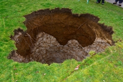
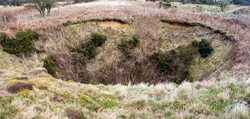 Picture: A dropout sinkhole near Cheddar, formed when cohesive loessic soil collapsed into an underlying cave (GB Cave) after heavy rain in 1968. The hole was partially infilled with old cars, and continues to slump today. The sediment formed an extensive mudslide in the cave below. Photo AR Farrant ©BGS/NERC.
Because the distribution of dissolution phenomena is highly dependent on bedrock and superficial geology, BGS has assessed the potential for dissolution hazards across the UK (including sinkholes, dissolution pipes, areas of irregular rock-head and caves) using 1:50,000 scale digital maps of superficial and bedrock deposits. These have been combined with other datasets, such as topography and superficial thickness, to produce hazard ratings. The detailed digital data illustrated in the map are available as attributed vector polygons, as raster grids and in spreadsheet format via the BGS Geosure dataset.
BGS is also constructing a more comprehensive database of karst features by collating site-specific data. Information is being culled from existing sources, such as historical and modern Ordnance Survey maps, cave surveys, academic papers and historical documents. Other datasets such as a legacy Applied Geology database are also being used to identify other sources of information. This site-specific data is being used to validate and improve BGS’s dissolution hazard maps. We welcome any reports of new sinkhole events, natural or otherwise, as this can help us assess the rate at which these features typically occur.
MEDIA STORM
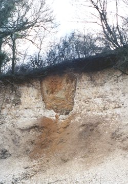 Picture: A dissolution pipe in the Chalk.
Most of the recent subsidence occurred on the Chalk in south and south-east England, principally because this was where rainfall was most extreme, and also because of the many shallow Chalk mine-workings and deneholes. Only a few were the result of natural dissolution.
One of the interesting aspects of the recent weather is the way the media reported the sinkhole events. Normally, sinkholes attract little or no publicity as they occur in upland or remote areas. Many form gradually over periods of time while others are simply not noticed or are infilled by the landowner without any fuss. The length and intensity of the media coverage was unusual given that the risk to human life from sinkholes is actually rather low. No-one was killed or injured in the recent spate, although the death of Mr Jeffrey Bush, who disappeared into a sinkhole in Tampa, Florida in March 2013, raised awareness of the potential risk to life.
The suddenness and unexpected nature of the phenomena are also fascinating, but attention spans are short. The clear media spike tailed off, even though more collapses occurred (including one that closed the B3356 in Somerset). An additional complication is that some reported ‘sinkhole’ events were not geological at all, but burst water mains or collapsed drains.
Although it is clear this winter’s heavy rainfall has caused a significant increase in subsidence events across the densely populated southeast, the reporting bias makes it hard to assess the true magnitude of this increase relative to the normal background rate. But it is clear that if predictions of more extreme weather events prove correct, then we can expect more sinkholes - of whatever variety - in future.
Acknowledgments
Special thanks to Vanessa Banks, Helen Reeves and Don Cameron who dealt with numerous sinkhole enquiries from the media, the public and government agencies.
References
- Culshaw, M. G., & Waltham, A. C. 1987. Natural and artificial cavities as ground engineering hazards. Quarterly Journal of Engineering Geology and Hydrogeology, 20, 139-150.
- Waltham, A. C., Simms, M. J., Farrant, A. R., & Goldie, H. S. 1997. Karst and Caves of Great Britain. Geological Conservation Review. JNCC.
- Edmonds, C.N. 2008. Karst and mining geohazards with particular reference to the Chalk outcrop, England. Quarterly Journal of Engineering Geology and Hydrogeology, 41, 261-278.
- Mortimore, R.N. 2012. Making Sense of Chalk. The 11th Glossop Lecture. Quarterly Journal of Engineering Geology and Hydrogeology, 45, 251-334.
Further reading
- Farrant, A R, and Cooper, A. 2008 Karst geohazards in the UK : the use of digital data for hazard management. Quarterly Journal of Engineering Geology and Hydrogeology, 41 (3), 339-356.
- Waltham, T., Bell, F.G. and Culshaw, M.G. 2005. Sinkholes and Subsidence: Karst and Cavernous Rocks in Engineering and Construction. Springer-Praxis Books. 416 pp.
Authors
* Dr Andrew R Farrant is a principal geologist at the British Geological Survey in Keyworth. Dr Anthony Cooper is an Honorary Research Associate at the British Geological Survey.