Duncan Hawley and Caroline Lam on the bicentenary of the world's first crowd sourced map
Hawley, D. and Lam, C., Greenough's World. Geoscientist
30 (1), 16-19, 2020
https://doi.org/doi: 10.1144/geosci2020-066,
Download the pdf here
 The two earliest geological maps of England and Wales hang side-by-side in pride of place at the foot of the stairs in the Geological Society’s apartments in Burlington House. Most people will be familiar with William Smith’s map of 1815, but perhaps less so the other - the Geological Society’s own map, issued five years later. Its chief architect was George Bellas Greenough, one of the founders of the Society and its first President.
Image: Photograph of the Entrance Hall, showing the two maps side by side (Greenough's map is on the left)
Early life and adoption
George Bellas was born on 18th January 1778 in London. Orphaned at the age of six, he was adopted by his maternal grandfather Thomas Greenough, a prosperous, self-made apothecary. Greenough first attended school in Slough and then, aged ten, went to Eton. But a year later in 1789 he transferred to Dr. Thompson's School in Kensington. Aged sixteen, his grandfather’s death left him a considerable inheritance, with George adopting his surname ‘Greenough’ as part of the terms.
I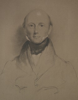 n 1795 he went up to Pembroke Hall, Cambridge to study law, attending nine terms. Ultimately he did not take his degree, through a principled choice of not accepting the required Church doctrines to graduate. In 1798 he went to the University of Göttingen to further his law studies, becoming friends with a group of English expatriate students, who included amongst their number the romantic poet Samuel Taylor Coleridge.
In Göttingen Greenough attended the natural history lectures of Johann Friedrich Blumenbach, encountering the mineralogy and geological ideas of the German tradition. He made at least two trips to the Harz Mountains during which he collected minerals and studied geological collections in the towns he visited. After further study at the University of Freiburg, he returned to Britain in 1801, now firmly converted to the natural sciences.
In addition to tours around Britain and the Continent, between 1801-1807 he was an active member of the Royal Institution, rubbing shoulders with contemporary scientists such as Humphry Davy and William Babington who were, like him, keen mineralogists. These men, along with ten others, would found the Geological Society on 13th November 1807.
Image: Portrait of George Bellas Greenough, c.1830s
The Society’s Map
Although accusations of plagiarism have been levelled at the Society’s map, most notably in Simon Winchester’s book ‘The map that changed the world’ (2001), the reality is more nuanced.
In fact the map was the culmination of a project set out in the Society’s first publication ‘Geological Inquiries’, (1808). In 1809 a map committee was “appointed for the purpose of forming maps by consolidating and arranging all such topographic information they may be able to procure relative to the extent and boundary of the different formations of which the British Isles are composed.” As progress on Smith’s projected map had apparently stalled by this date, the most obvious solution for the Society was the preparation of its own geological map of England and Wales.
From the outset it was a collaborative effort. Greenough assumed the role of editor, gathering observations from Society Fellows, associate members and “persons in every situation in life” who had expert knowledge of the areas where they lived or frequented, and adding details from his own travels. In the map’s accompanying memoir, Greenough acknowledged particular contributions from William Buckland, and noted help received from others including W.D. Conybeare, Henry Warburton, Arthur Aikin, Joseph Fryer, Henry De la Beche, John Farey and the Reverend John Hailstone.
A first draft of the map was ready by 1812 but publication was delayed in order to produce a base map that could accurately portray relations between the topography and underlying strata. An outline version of the new base map, drawn by Thomas Webster at a scale of six miles to the inch, was complete by the end of 1814, but it took the engraver, Samuel Neele, a further five years to add the topographical and geological detail to Greenough’s satisfaction. The first edition of Greenough’s map is engraved with a date of November 1819, but actually wasn’t issued until 1st May 1820.
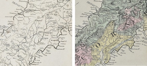
Greenough’s ‘crowd sourced’ approach resulted in the map being more geologically and topographically detailed and accurate than Smith’s map of 1815. Records show 350 copies were produced, with a number presented to dignitaries, august societies and close collaborators. One was even presented to William Smith. A second revised edition was published in 1840 and a third (posthumous) edition appeared in 1865.
Reconstructing the Greenough Map Bequest
On his death on 2nd April 1855, Greenough’s geological and geographical collections of books, maps and prints were bequeathed to the Geological and Royal Geographical Societies, respectively.
His book bequest forms a significant part of the Geological Society’s Rare Book Collection but his geological maps were integrated into the existing map collection. Those which were his own manuscript, hand-coloured drafts have been transferred to the Society’s Archives, but many others, with his own annotations, have remained scattered within the Society’s Map Collection.
Greenough is sued only three geological maps in his lifetime – ‘Geological Map of England & Wales’ (1st edition, 1820, and 2nd edition, 1840) and ‘General sketch of the physical and geological features of British India’ (1854) – yet his collection indicates that his mapping activities were far more extensive. Central Europe, especially the areas around Germany, features large in the collection but his maps cover much of the countries and continents of the world. Just over 330 maps survive, and most show the wear and tear of having being used and handled for over 160 years. During the Greenough Map Bicentenary conference (due to take place in May 2020 but now postponed until 2021) the map collection of our first President will be displayed together for the first time, allowing us to understand Greenough's mapping activities more fully.
Duncan Hawley is Chairperson of the Geological Society’s History of Geology Group (historyofgeologygroup.co.uk)
Caroline Lam is the Geological Society's archivist.
_____
Due to the present COVID-19 circumstances the Greenough Map Bicentenary meeting scheduled for 6th and 7th May this year will not take place but is postponed until May 2021. Further information and registration details can be found the HOGG website (historyofgeologygroup.co.uk).