Tom Power discusses the use of Smart Phones in the field
Smart phones act as mini computers and can be interfaced with other computers running Window and Mac operating systems. Internet browsers such as Google and Firefox allow the internet to be fully accessed. This gives the geologist, with a smart phone, not only a means of personal communication but also allows sources of information to be immediately available to him. Various chunks of data and programs can be downloaded in applications (apps ) and stored on the smart phone, making it easier to access. Apps icons appear on the desktop screen, along with widgets which are small subroutine programs.
Smart phones almost invariably have a high resolution camera which is the main input for images and video. The data is held in either JPEG or mp4 files, readily accessed by the image viewer or the video player on the smartphone.
Resolution
The image resolution is high by other standards and there may be over 4Mb of pixels within each image. The magnifier app allows a magnification up to 5x, so there is no need to retire the standard 10x hand lens just yet but it is a useful standby and is useful in its’ own right. The Telescope HD app produces a camera image on the screen and by moving the button at the bottom to right increases the zoom.
A thermal camera app is also available which produces false coloured infra red light images by filtering out the visible light. The images reflect the surface temperature of materials. Hence in a geological exposure containing cool moist clayey beds and warmer sandy beds and rock, the geological units may be depicted on the IF image. There are similar apps for UV light but unless UV light is present in the illuminating source such as a UV lamp or direct sunlight, there may not be significant interest in UV images for geologists. Some resins such as amber and oils, however, do reflect UV light, in their iridescence.
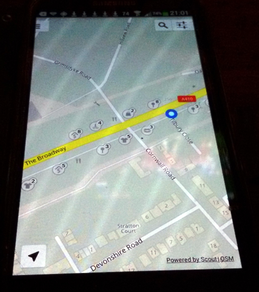
The smart phone is increasingly being used as position fixer. It has its own global positioning system (GPS) using satellite data but it can also fix its own position from the WIFI stations on the networks. Many apps are available which provide maps, indicating the smart phone position, usually by a round blue dot on the relevant map on the screen. These apps are used mainly for navigation but some allow the positional data to be converted into world coordinates i.e. longitude and latitude (Scout app).
Bookmarking and using the BGS website listed at the end of the article allow these values to be converted into the national grid co-ordinates. Comparing the indicator on the map shows that the accuracy of these devices may initially wonder due to the lack of satellite control and hence before establishing the co-ordinates the geologist should allow a little time before the position is fixed. A photo of a Scout map image is given showing the blue dot marking the current location (picture).
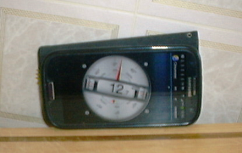
The accelerometers, pressure and magnetic sensors in smart phones, keep the image on the screen upright and plot the global positioning on the screen. These sensors are used in several apps to produce magnetic compasses, horizontal levels and inclinometers. The inclinometer must be calibrated along the axes of the smart phone in the direction of true dip. The photos below show a smart phone being used as a clinometer. The reading, which is very clear, was within 0.5 deg of the known dip of the board.
 Apps on the smart phone can record elevation in several ways. Firstly it may determine it directly from the GPS, secondly it may use its location to establish the level from map data such as Google Earth and lastly as an altimeter using the pressure sensors in the smart phone.
One app gives values for all three. GPS elevation data is likely to be affected by the atmosphere when satellites are at a low angle in the sky, whilst satellites which are high in the sky are at a tangential disadvantage. Woods and buildings may also block the satellite signal. As in Southern England where there are large with low gradients the second method seems to be most accurate whilst the altimeter method is useful on steep hillsides and mountains and underground.
For an altimeter to function accurately the ambient air pressure at sea level needs to be established. This can be done on the smart phone in two ways:
- Bookmarking and using the surface air pressure charts of the Meteorological Office or data from a local weather station. These will give the air pressure already adjusted to sea level.
- From a known positional height, using the elevation and the ambient air pressure, to estimate the pressure at sea level. If the same location is used again at the end of any survey then any drift in air pressure can also be assessed and the recorded ground levels accordingly adjusted. Again a website is available to help with this process. The air pressure charts from local weather stations can also be used for the same purpose.
Compass
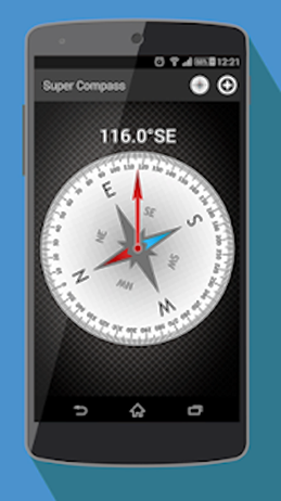
There are several magnetic compass apps available. Some of the compasses have images which flicker due to constant updating but generally they appear to be within one or two degree of readings from normal pocket compasses.
Photo ruler is an app which allows comparison between the size of a reference feature e.g. a man against an outcrop to determine the height of the face, or a coin against a fossil. The reference object should be at least 20% of the height of the feature as the setting of the reference scale does become difficult when this ratio is low.
Another app measures the angles between the top of a feature and the base and to determine the height, from the height of the smart phone camera above the base level.
Sensor Kinetics and Weather Signal are apps which access data from the range of sensors contained in the smart phone. Data files may be downloaded from the apps. Sensors which measure the external air temperature and humidity may not be present in the earlier versions of smart phones. Both apps will produce a seismic wiggly trace which would allow a pair of smartphones to be used to measure the insitu seismic velocity of rock once the timing of both smartphones had been synchronised. The gravity and magnetic sensors allow the smartphone to be used possibly as a gravimeter or a magnetometer. In this area the smartphone can be viewed as a mobile physics laboratory.
The amount of data space in a smart phone is amazing i.e. 35+GB This is more than enough for a number of pdf files to hold any reference material which could be seemingly be needed on a field trip. There are also external databanks which can be used to store and access information but these will require the smartphone to work online. Tide tables and weather forecasts are especially useful.
Google drive is a collection of apps which include Google Documents and Google sheets. Google sheets, is a spreadsheet app compatible with Excel 2010, and capable of reading and producing CSV data files. Data can be stored on the device or online. It should be possible to produce software to record all the field survey data automatically within a data file. This would include the gaps, corrected to National Grid and altitude from the methods already discussed.
Except where data is required from a current source, the GPS and most of the apps described above do not need the internet. The batteries in a smart phone will only support a few hours of continuous heavy use. The GPS and associated apps are particularly heavy on battery power, but an inexpensive booster should stretch this period out to a full working day.
Webpages to bookmark
Apps available from Google playstore.com
- Scout: Position fixing, navigation and co-ordinates
- Thermal Camera: Infrared spectrum
- Photo Ruler: Measurement
- Distance Meter: Measurement
- Magnifier: Lens
- Telescope HD: Zoom viewer
- Accurate Altimeter: Elevation
- Magnetic compass: Direction
- Inclinometer: Tilt
- Weather Signal: Multi sensor recorder
- Sensor Kinetics: Multi sensor recorder
- Tides near me: Tide tables