 Applied geology and airfield construction suitability maps compiled remotely for Hong Kong in WW2 illustrate techniques pioneered by military geologists, says Ted Rose*
We have already seen (Geoscientist 22.3, April 2012) how, in WW1, groundwater and engineering geology maps compiled for the Western Front in Europe helped pioneer militarily applied geology in the British Army. WW2 however was a more mobile conflict, fought over a greater range of terrain and stimulated geologists to compile new types of map for military use. Such maps were generated in the USA by the Military Geology Unit of the US Geological Survey, for many parts of the world1. Other maps were generated in the UK for the Allied liberation of Normandy2, and operations elsewhere in Europe and the Far East3,4. Maps of Hong Kong, preserved in London in the libraries of the Geological and Royal Geographical societies conveniently illustrate two of the major types of this innovative mapping, at an unusually detailed scale.
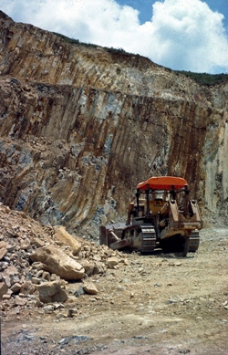
Picture: Polygonal jointing in Jurassic volcanics, Hong Kong.
Hong Kong lies on the southern coast of China. A rugged terrain of fiords, islands and mountains, it comprised about 1000 km2 in total land area before major reclamation projects. Restored to Chinese sovereignty on 1 July 1997 as the Hong Kong Special Administrative Region, components of the territory had been ceded or leased to the UK from 1842 onwards. By WW2, it had been progressively developed as a British naval base and fortified against southerly seaborne attack. However, early on 8 December 1941, the day after Japanese attack on Pearl Harbor, Japanese forces in China attacked from the north, by air and land. The garrison of British and Canadian plus local defence forces was finally overwhelmed on 25 December, and Hong Kong was to be under Japanese occupation for nearly four years. However, as the tide of war changed in the Far East, the British Army began to formulate plans to return.
THEMATIC MAPS
To guide British military planning in the later years of World War II, thematic maps and reports were compiled remotely in the UK for many areas of potential military operations. Compilation was by the ISTD: the Inter-Service Topographical Department3,4. Founded in London in May 1940 as part of the [Royal] Naval Intelligence Division, the unit transferred to Oxford in October 1940, and in October 1941 became ISTD with a role to provide topographical intelligence for the British armed forces as a whole. It was to expand by the end of the war to an organisation of about 300: over 700 including regional branches and specialist sections.
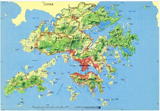
Map above: Hong Kong with relief hachured in green, major roads shown in red, and the major geographical areas (Hong Kong Island, Kowloon and the New Territories) named boldly in black. Based, with permission, on a 1:200,000 map © Hong Kong Government 1980.
 The nucleus of a Geological Section was created in November 1943. This comprised two geologists, both recently granted ‘emergency’ commissions as officers in the Royal Engineers (RE) and (on appointment to ISTD) ‘acting captain’ status because of their age and professional standing.
One was ‘Tom’ Phemister (1902-1982, left, in a postwar photograph, from Rose & Clatworthy (2008), courtesy: School of Geosciences, University of Aberdeen) an alumnus of the universities of Glasgow (BSc) and Chicago (MSc), had been a research student at Cambridge until appointed Associate Professor of Geology and Mineralogy at the University of British Columbia in Vancouver, Canada, in 1926. He returned to the UK in 1933, to a demonstratorship at Cambridge prior to promotion in 1937 as Professor and Head of the Department of Geology and Mineralogy at the University of Aberdeen. In 1943 he was (after earlier refusal) eventually accepted as a volunteer for military service – and selected for assignment to ISTD while serving at the RE Survey Training Centre.
 The other was ‘Jack’ Farrington (1906-1982), born in Sydney, Australia, to English parents, who had graduated from the University of British Columbia as a Bachelor of Applied Science in May 1928 – having been taught by Phemister. After graduation, he became a field and mining geologist in sub-Saharan Africa. He too had to wait for changed admission criteria (in his case, poor eyesight) before acceptance for military service; but at the end of 1942, he too was posted to the RE Survey Training Centre - before assignment to a Corps Field Survey Company RE. He returned to the Training Centre for more specializsed courses from 18 July to 12 October 1943, and was thereafter assigned to ISTD.
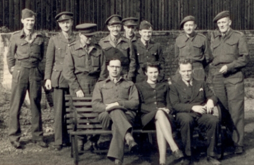
Picture, above right: The Geological Section ISTD, March 1945 behind the ISTD huts near Mansfield College, Oxford. From left to right, back row: Captain M R F Ashworth (a soil chemist), Lieutenant (later Captain) J R Foster-Smith (mining engineer, later FGS), Lieutenant (later Captain) W R Williams (economic geologist), Lieutenant (later Captain) A Ludford (geologist), Captain W E Fraser (petroleum geologist), an unidentified RAF draughtsman, another draughtsman (probably Sapper Hunt), and the Section head: Major J L Farrington (economic geologist). Sitting in the front: Captain A D M Bell (petroleum geologist), Miss Jane Labey (Section typist), and Mr L C Huff (one of two US Geological Survey’s Military Geology Unit geologists who served with the Section 18 January to 15 March 1945). Most geologists appointed or attached to the Section came from the Royal Engineers. Photograph and identifications courtesy: Dr Albert Ludford.
LEADERSHIP
Appointed to work separately, the two quickly arranged to work together, forming the leadership of a group that in September 1944 was formally established as a ‘Geological Section’ (including soil scientists as well as geologists), comprising an RE major plus three captains. Phemister had been released from the Army back to his university role in August 1944, so Farrington was duly promoted Major and Section leader.
To ease pressure of work, the Section was progressively enlarged with geoscientists and engineers from other units. The number of ISTD ‘geologists’ actually working together rose to a peak of 12 by the end of the war in August 1945 - before the Section was reduced in strength and finally, in June 1946, disbanded. By that time 19 ‘geologists’ in total had served within it, including three Americans, one Canadian, and (very briefly) Dutch sedimentologist Philip Henry Kuenen.
MAP WORK
In 1944 and 1945, the Section contributed to 10 major reports and 14 ‘special tasks’ for Europe, and 21 reports and 17 tasks for the Far East - all illustrated by at least one specialist geotechnical map.
The earliest reports included published geological maps (e.g. a 1:756,720 geological map of Malaya), reprinted for the War Office by the Geographical Section, General Staff (GSGS). Later reports, dealing with countries for which no suitable geological map existed (typical in the Far East), included new maps hastily compiled from published and oil-company sources. Uniquely, Hong Kong had a geological map already printed in GSGS style. Since the territory was small, this was at the scale of 1:84,480 (3/4 inch: 1 mile) – unusually detailed for the Far East at that time.
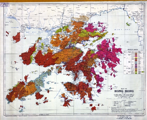
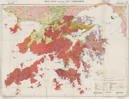
Picture above left: ‘Geological Survey of Hong Kong,’ original scale 1:84,480, by R W Brock. S J Schofield, M Y Williams and W L Uglow of the University of British Columbia, Canada, printed 1936 by the Ordnance Survey, Southampton, on 1932 revision of GSGS 1393 as a topographical base map. Map sheets preserved at the British Library, London, and Bodleian Library, Oxford, record that 350 copies were printed in 1936, at least those delivered in July 1936 to GSGS with red grid lines superimposed; 500 copies were reprinted in May 1950, 1,000 in January 1955, both sets without the red grid. The geological legend distinguishes 16 rock units. From the top down, beneath Recent regolith and sediments (blank, unnumbered), these comprise 1. syenites, granites, 2. dykes, 3. volcanics (all dated as Miocene); 4. red sediments (Eocene); 5. porphyry, 6. granite, 7. porphyritic granite, 8. porphyritic syenite, 9. syenite, 10. volcanics (all dated as Cretaceous); 11. granodiorite, 12. porphyries, 13. volcanics, 14. metamorphosed sediments, 15. sediments, 16. volcanics and sediments (all Jurassic). Courtesy: Library, Geological Society of London.
 Geological investigation had begun early in the period of British administration, but this first geological map was printed only in 1936. Files WO 181 and CO 129/576/3 in the UK’s National Archives at Kew record the background. On advice from the British Geological Survey and the Colonial Office, London, the Hong Kong Government asked the Geology Department in the University of British Columbia, at Vancouver in Canada, to undertake a geological survey. The University then provided four geologists (R W Brock - pictured right, S J Schofield, M Y Williams and W L Uglow) to map the territory5. The final map, a geological overprint on the GSGS 1393 topographical base map, was printed by the Ordnance Survey at Southampton – like geological maps for the Western Front in World War I – and a version with a reference grid superimposed received by GSGS in July 1936.
Picture: Professor R W Brock (1874-1939), who enlisted in the 72nd Seaforth Highlanders of Vancouver, Canada, on the outbreak of World War I, and later served in Palestine in the rank of major. © University of British Columbia.
The map showed that Hong Kong was clearly an area of predominantly extrusive Jurassic volcanics, intruded by an extensive complex of granites; its bedrock partly covered with a deeply weathered regolith or (in the valleys) Quaternary alluvium. However, during 1944 it had become apparent that such maps were of little military use without an interpretation readily intelligible to non-geologists.
APPLIED GEOLOGY
 Following the precedents of WW1, one of the ISTD geologists’ tasks was to generate geological maps in which technical data were reduced to a minimum and the military significance of geological features was made clear.
Picture: Simplified geological map of Hong Kong, original at scale of 1:80,000, prepared by ISTD geologists in 1944 for report BR 1208D(2) issued January 1945. For explanation, see text and Figure 11. Reproduced by permission of the Royal Geographical Society Library.
In 1944, ISTD geologists generated two such maps for Hong Kong, adopting military metric scales: a single sheet at scale of 1:80,000, and two sheets, including part of nearby China, at 1:250,000. Examples of the 1:80,000 maps are now elusive (one copy is preserved in ISTD report BR 1208D(2) in the Royal Geographical Society library), but several copies of the 1:250,000 maps are preserved in London, notably in the British Library and the libraries of both the Geological and the Royal Geographical societies.
 Maps at both scales group rocks by use of three principal colours, with colour intensity varied so as to increase to five the main units depicted:
- pale yellow (surface deposits: Recent)
- deep yellow (younger sedimentary deposits: Tertiary)
- pale red (younger igneous rocks: Tertiary)
- green/blue (older sedimentary deposits: Palaeozoic and Mesozoic)
- deep red (older igneous and metamorphic rocks: mostly Mesozoic).
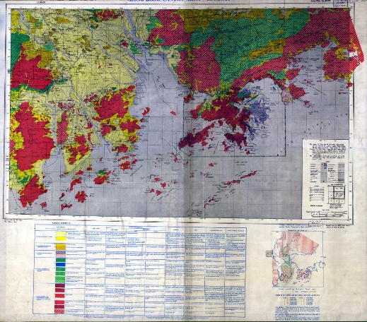
Picture: Part of geological map of Hong Kong and Canton, south sheet (of two), original at scale of 1:250,000 (GSGS Miscellaneous map 192A), compiled and simplified by ISTD geologists in 1944 (cf. Fig. 10). Inset diagram defines geological reliability in terms of areas mapped at five different scales, or known only from small-scale maps and from reports unaccompanied by geological maps. For explanation, see text. Courtesy: Library, Geological Society of London.
The coloured ‘rock groups’ are subdivided by shading or overprint to differentiate a larger number of categories: 10 in the key to the 1:80,000 map, 18 on the 1:250,000 map. An extensive key to the maps tabulates data for each of these categories in six principal columns: rock types, rock characteristics (three sub-columns: structure, properties fresh, weathered), terrain, soils, underground water, and construction materials. For the 1:80,000 map, a final column provides notes on undifferentiated rock groups, reliability, and sources.
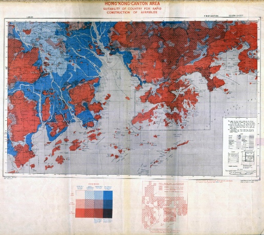
Picture: Part of map of Hong Kong and Canton showing suitability of country for the rapid construction of airfields, south sheet, original at scale of 1:250,000 (GSGS Miscellaneous map 192B), prepared by ISTD geologists in 1944 partly on the basis of geological data (cf. Fig. 12). Inset map defines reliability in terms of topographical mapping at three scales; also ‘For reliability of soil information see Reliability Diagram on Geology Map’. For key, see below. Courtesy: Library, Geological Society of London.
January 1945 brought completion of report BR 1208D2 to accompany the maps. The report notes specifically that the ‘large scale [1:80,000] geological map ... is reproduced from the map by the Government of Hong Kong Colony, slightly modified so as to conform to the system of rock groups on plan 55 [the 1:250,000 map], and transferred to a more recent topographic base’. ‘Local stratigraphical names of formations have been avoided as much as possible [on the maps], but have been supplied in the stratigraphical table in Appendix B [of the report]’.
GO, NO GO, SLOW GO
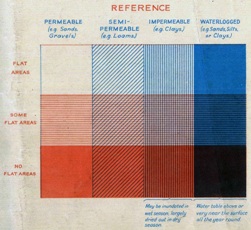 Picture: Key to map of Hong Kong and Canton (Fig. 13) showing suitability of country for the rapid construction of airfields. Courtesy: Library, Geological Society of London.
The report was generated remotely, based on the existing information available in the UK. Publication of a monograph to accompany the 1936 geological map had been delayed by the deaths of Uglow in 1926 and Brock in 1935, and its first draft was lost in wartime Hong Kong. Associated publications did not begin to appear until late in the war, the first by Williams in 1943, the second (including contributions by Phemister and, posthumously, by Brock) in 19456.
Use of only a few colours made it easier for non-geologists to appreciate key features ‘at a glance’: red, green/blue and yellow tints gave an initial impression of ‘go’, ‘slow go’ and ‘no go’ areas for usages specified in the key’s columns. Thus for ‘construction materials’, areas coloured yellow were ‘no go’ for sources of good roadstone but potentially ‘go’ for sands or clays; red areas were in contrast ‘go’ for quarrying good road aggregate; and green/blue areas were likely to yield rocks of more variable properties, so ‘slow go’. Use of few colours also made the maps cheaper and easier to print.
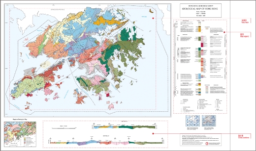
Left: Geological map of Hong Kong, 1st edition published in 2000, at scale of 1:100,000. © Hong Kong Geological Survey, printed by permission.
Such maps showing ground characteristics of military engineering significance were compiled by ISTD geologists for several areas of the Far East: Sumatra, Indo-China, the Kra Isthmus of Burma (now Myanmar) and Siam (now Thailand), Siam, and Java in similar coloured style, Borneo and Formosa in monochrome. However, all were at much smaller scale, most of them at 1:1 million. The Hong Kong maps were the most detailed maps of this type printed for wartime Allied use – precursors of ‘terrain engineering characteristics’ maps developed for military use in other countries postwar.
AIRFIELDS
A map showing ‘suitability of country for rapid construction of airfields’ was included in the 1945 report. A grey topographical base map was overprinted in only two colours. Blue indicated the permeability of ground, red its flatness – following the precedent set in 1943 by a map for NW France (Geoscientist 22.3, April 2012). Printed together these were shaded to define 12 categories of terrain, of which areas left blank were the most suitable for rapid construction of airfields, those in dense purple the most unsuitable.
Maps of similar style had been printed in 1944, first for Malaya at 1:380,160, then Sumatra, at 1:750,000, and for the Kra Isthmus of Burma/Siam, at 1:1,000,000. The maps for the Hong Kong – Canton region at 1:250,000 were thus larger in scale than these earlier maps: consistent with 1:250,000 Hong Kong maps prepared by other ISTD sections, for roads and waterways, and main telecommunications.
Notes beneath the two final columns of the key: ‘may be inundated in wet season, largely dried out in dry season’ and ‘water table above or very near the surface all the year round’ take account of criticism that the earlier maps did not indicate sufficiently clearly the importance of seasonal rainfall to airfield construction. Later maps (for Siam and Indo-China at 1:1 million, and for the Chinese island of Hainan and for Java at 1:500,000) distinguish 15 rather than 12 categories: the ‘waterlogged’ column being divided into two – seasonally waterlogged (pale blue) and permanently waterlogged (dark blue).
None of these maps was intended to indicate specific sites for potential airfields. Rather, their purpose was to give planners an overall appreciation of possibilities for rapid construction, and to indicate the most likely areas for future ground reconnaissance. Postwar criticisms held that the maps, being of small scale, were inadequate except for the broadest generalisations, and that users tended to expect too much from them – probably because they were, in many cases, the only source of engineering information available.
POSTWAR MAPPING
 Allied military operations focused primarily on Burma, Indonesia and the Philippines, and Hong Kong remained in Japanese hands until the war in the Far East ended on 14 August 1945. Terrain assessments by the British military geologists were never put to operational test.
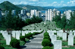
Picture: British Commonwealth War Graves - photographed c. 1977.
After British troops and administration returned to Hong Kong, local civilian studies, notably by S G Davis and later B P Ruxton, demonstrated the need for a new survey. Carried out between January 1967 and March 1969 by geologists seconded from the UK Institute of Geological Sciences (as BGS was then known), this generated a new geological map at 1:50,000, contained within a substantial report7: the standard work of reference for the next decade, as major urban development rapidly gathered pace.
Also postwar, the British Army disbanded ISTD and its Geological Section. From 1947 geological expertise was provided by a few officers appointed to serve in the reserve army, in the ‘Geologists Pool’ (1967-1987, re-constituted as the ‘Engineer Specialist Pool’) of the Royal Engineers. These geologists were used to support military or civilian communities by brief assignments in many countries8. Some were used on Hong Kong to assess potential new well-sites for groundwater abstraction and aspects of quarrying, and to assist with studies of slope stability. Deemed to have acquired sufficient local and general experience to be useful, yet to be free of any potential commercial interest, Specialist Pool geologists were invited in 1981 by the Geotechnical Control Office of the Hong Kong Government to review the need for a new geological map and survey. With the foundation, as recommended in their report9, of a Hong Kong Government geological survey unit, British military geological association with the region came finally to an end.
HONG KONG SURVEY
Effectively founded in 1982, the Hong Kong Geological Survey has generated an extensive revision of the geology of Hong Kong10,11 accompanied by a range of new maps. Moreover, a thriving Regional Group of the Geological Society of London now addresses the professional and learned needs of Hong Kong geologists (www.geolsoc.org.uk/hkrg).
Long-obsolete military associations with local geology are thus now but minor footnotes to a rapidly increasing and impressive history of published research, both ‘pure’ and ‘applied’. However, they serve to illustrate a wartime phase in the history of engineering geology that is largely unknown to both historians and geoscientists: work that was initially ‘secret’, but may now be put in the public domain. The mapping techniques illustrated here were to prove their value in combat areas far distant from Hong Kong.
* Colonel Ted Rose is Honorary Research Fellow in Earth Sciences, Royal Holloway, University of London. E: [email protected]
References
- Nelson, C M & Rose, E P F 2012 The US Geological Survey’s Military Geology Unit in World War II: ‘the Army’s pet prophets’ Quarterly Journal of Engineering Geology and Hydrogeology, 45, in press (for August).
- Rose, E P F , Clatworthy, J C & Nathanail, C P 2006 Specialist maps prepared by British military geologists for the D-Day landings and operations in Normandy, 1944 The Cartographic Journal, 43, 117-143.
- Rose, E P F & Clatworthy, J C 2007 Specialist maps of the Geological Section, Inter-Service Topographical Department: aids to British military planning during World War II The Cartographic Journal, 44, 13-43.
- Rose, E P F & Clatworthy, J C 2008 Terrain evaluation for Allied military operations in Europe and the Far East during World War II: ‘secret’ British reports and specialist maps generated by the Geological Section, Inter-Service Topographical Hydrogeology, 41, 237-256 (discussion: 42, 133-136, 389-392).
- Ruxton, B P 1957 The work of the Canadian team of geologists in Hong Kong Far Eastern Economic Revue, 22, 195-197.
- Williams, M Y , Brock, R W , Schofield, S J & Phemister, T C 1945 The physiology and igneous geology of Hong Kong and the New Territories Transactions of the Royal Society of Canada, 39, 91-119.
- Allen, P M & Stephens, E A 1971 Report on the geological survey of Hong Kong 1967-1969 Government Printer, Hong Kong.
- Rose, E P F & Hughes, N F 1993 Sapper Geology: Part 3 Engineer Specialist Pool geologists Royal Engineers Journal, 107, 306-316.
- Rose, E P F , Cocks, L R M & Peace, G A P 1981 Report on the feasibility of a new geological survey and map of Hong Kong, Kowloon and the New Territories Unpublished report, Central Volunteer Headquarters Royal Engineers, Minley Manor, Surrey, UK.
- Fyfe, J A , Shaw, R , Campbell, S D G , Lai, K W & Kirk, P A 2000 The Quaternary geology of Hong Kong Hong Kong Geological Survey, Hong Kong.
- Sewell, R J , Campbell, S D G , Fletcher, C J N , Lai, K W & Kirk, P A 2000 The pre-Quaternary geology of Hong Kong Hong Kong Geological Survey, Hong Kong.