Some progress has been made in deciphering a few of the enigmatic symbols which occur on kerbstones, writes Peter Dolan.
Following my previous article 'Kerbstone Conundrum' (Geoscientist 23.5 June 2013) it is now possible to erect at least four categories, based on evidence primarily within London, the first of which is an ‘outlier’.
Parish Boundaries (London and maybe other cities)
 These markings are not those which were discussed in the initial article since they are of a totally different pedigree. A recent independent survey (Mike Horne, personal communication) suggests that there are about 800 surviving parish boundary marks in streets within the former County of London area, the vast majority are stones or plaques affixed to buildings or as stones or columns mounted in the street.
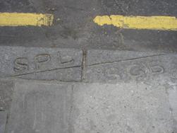
More germane to this article are a small proportion observed on pavements including 29 kerb-inscribed boundary marks usually comprising the initials of the parishes on either side, see Figure 1 (left). In some cases the kerbing changes either side of the boundary, each parish favouring a different type of stone. In other cases a joint stone is used, usually with the boundary line cut into the surface in its correct trajectory. Quality varies, some are superb, and they are nearly all of a higher quality than the apparently random and far more numerous markings that led to the original article. These parish boundaries have been identified by locating boundary lines on 19th Century mapping and then walking the routes to note what has survived.
In the County of London, civil parish boundaries became redundant when the Metropolitan Boroughs were created in 1900 but a few of the successor boroughs persisted in installing fresh markers, even where boundaries were unchanged. Paddington, Islington and Hammersmith are boroughs known to have installed later marks.
Borough Maintenance Boundaries
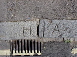 This is a category of letters and symbols which, on a prima facie basis, appear to be part of the puzzle that has been identified. However, they may be rare; only one pair has so far been located. This pair are where a borough boundary ran longitudinally along the centre of a road, but an agreed transverse boundary half way along the joint section of road was created, each borough dealing (for maintenance purposes only) with the whole of the length of road assigned to it. The recorded example is where the letters H and A appear next to each other on both sides of the road, denoting the boundary between Hammersmith and Acton, see Figure 2 (right).
Government Property
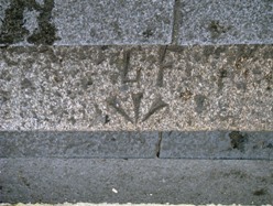 In Whitehall there are some magnificently etched arrows of the type which were introduced in the late 16th Century to mark objects purchased using the monarch’s money and which were later adopted to mark all government property, see Figure 3 (left). They are characterised by the flared nature of each of the three elements of the arrow. Exactly what these particular arrows are meant to convey has not been fully researched. However, this stretch of road (originally known as Charing Cross) was widened on this side in the 18th Century at government expense.
Most geologists will be familiar with the same arrow (with accompanying horizontal line) on triangulation pillars and bench marks however, there are other occurrences. Ordnance Survey officers conducted some of their triangulations aloft, setting up control point observatories as high as possible to get extended sightings. Most of these would have been churches and reportedly included building a 92-feet high wooden structure on the cross of St. Paul’s Cathedral. Up to 10,000 readings were taken this way and about 900 points were observed, which were then reportedly marked for posterity on the pavement (? directly) below by the classic government arrow. The area surrounding St. Pauls has not been investigated. Oddly a classic government arrow and line has been found in New Road in Oxford, far removed from any currently tall building; why it is there is a mystery.
Another form of ‘government’ kerbstone mark, is GPO (sometimes GP+O and P↓O), clearly referring to the General Post Office which long ago (during the author’s youth) ran the national telephone system.
The GPO acronym persisted until 1969 after which it was PO until the 1980s when BT was formed. The telephone system is relatively new, in the context of this enquiry, being uncommon until after WWI. Prior to that it was the telegraph system that predominated, mainly for business purposes, see section 4.C. below.
Service Marks
Electrical
In correspondence with a retired employer of the LEB (London Electricity Board) a list of possible, but as yet unsubstantiated explanations has been proffered in Table 1 (below):
DX Duct Crossing (perhaps local exchange to trunk exchange).
E Electricity.
EHT Extra High Tension (ie Extra High Voltage).
H House Box or House Joint (ie service joint to a property).
HT High Tension (High Voltage).
HV High Voltage.
J Joint (ie Joint on an electricity cable).
LVE Low Voltage End (same as Pot End – see below).
P Pipe.
PE Pot End (ie the end of a cable).
S Service Joint (see H above).
SB Service Box (an alternative to H).
Table 1
As yet, there is insufficient evidence to accept these meanings as being the holy grail explanation; why? First, no documentary evidence has been accessed to corroborate them. Secondly, electrical supplies were not common until the early 20th Century and much of the terminology was not in use until many years later. Thirdly, the marks are not usually widespread or uniform in occurrence (they are not, for example, common in the City of London, a huge user of services from an early date). Finally, there were dozens of private electric companies in the early 20th Century many of which merged and eventually were nationalised in 1947 as the London Electricity Board; it is highly unlikely that they used the same code.
The SB in Table 1 may represent ‘Service Box’, but there could be another explanation; one correspondent has suggested that SR, SB and SY (none of the latter found to date) could represent electrical services relating to the red, blue, and yellow colours of three-phase AC underground cables. Anybody following up on this line of enquiry is forewarned of the likely complexities introduced by varying phase supplies and evolving colour coding systems. Again, verification is needed from archive documents.
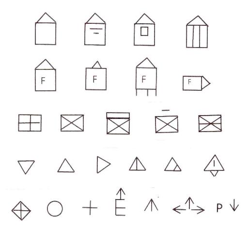 Another source reports that a diagonal cross in a rectangle was used by Hampstead Electric Supply Company to indicate a duct/pipe crossing (when marked on a kerb), a cable joint (when marked on a paving slab) or a service cable entry (when marked at the base of a wall). This use of a symbol, rather than letter(s) in the Hampstead area to convey information on electrical infrastructure seems to have been the case also in Newcastle, see Figure 4 (right). A long-retired employee of the Newcastle Electricity Supply Company (NESCO) reportedly stated in 1979 that these symbols related to cable jointing, fuses, etc; however, the meaning of the code has been lost. Any reader of this article who has the time and inclination to search for, photograph and identify such marks will earn a place in the pantheon of kerbmark spotters!
Gas
in some places, the word Gas is marked. Whether or not the letter G alone is an abbreviation for gas is, at present, a matter of pure speculation.
Telephone
Apart from the GPO symbol previously mentioned it would be logical to consider the letter T indicating telephone or telegraph services, but assumptions can be dangerous. For example, the GPO used a small metal tablet mounted vertically – this was more visible than anything on a flat stone which might get covered by detritus and be invisible at night. What is more, until GPO took over telephones in 1912 most telephone lines were on overhead wires. There were also some extensive private systems in London, notably the Exchange Telegraph Company that had a substantial network. Then there were the hundreds of pneumatic tubes in the City of London, mostly terminating at Central Telegraph Office.
Perhaps T, in certain circumstances, represents an administrative unit. Whilst a T in the author’s stomping ground might be thought to represent Twickenham, this is unlikely since the borough wasn’t created until 1926.
Water
There are remarkably few examples known, of any obvious reference to water supplies. A few examples of W alone and Sw do exist, perhaps meaning water pipe, as well as F alone, possibly alluding to a fire hydrant.
Whilst S may be the generic term for a ‘Service’ one might ask if it could relate to sewers. However, if so, it would be expected to be far more ubiquitous, which it isn’t, so this possibility is considered to be highly unlikely.
Probably (?) Services
As a result of some diligent work by another correspondent in the Bradford area a bewildering array of different letter and symbol combinations have been recorded that are variants on some of those described above for services. However, what S+, S-, S+C, 3SE, -S and <7B>, for example, mean is still a mystery to the author.
Unknown
In addition to the letters and symbols mentioned above, there are many others, newly identified along with those in the footnote of the original article in Geoscientist, which remain an enigma; possibly, most of them are related to utility services. Unfortunately, the myriad of parishes, councils, private utility companies, possible use of sub-contractors and the development of extensive estates all militate against the probability of common codes having been adopted.
Further progress
So, how to progress? It appears that the identification of kerbstone marks will need investigation of local private utility company and council archive files, if they have been preserved. Perhaps one of the richest seems would be the LEB files which are held in the London Metropolitan Archives, any volunteers?
Acknowledgments
Acknowledgments and thanks are due to several people who have taken up the challenge to be code-breakers. First is Mike Horne who must be the world expert on London parish boundaries and who is well versed on the development of roads, electricity and related services within Central London, Peter Wigley for pointing out an article ‘The Ordnance Survey Goes Aloft’, Michael Money for his contribution of kerbstone marks in and around Newcastle and his awareness of the erudite subject of industrial archaeology, Peter Scott (erstwhile employee of the London Electricity Board – LEB) for his suggestions in Table 1, Derek Barker for his extensive study of marks in and around Bradford, Douglas Helm and his dog-walking friends for their observations in Lee Green and finally the numerous people who have sent photos from their neighbourhoods in the spirit of enquiry.
Having made some limited headway in cracking the kerbstone codes, it is planned to hold a meeting at the Geological Society for those who have images of kerbstone markings and plausible and verifiable explanations for their local meanings. If you are one such, please contact Sarah Day at [email protected], so the level of interest in a meeting can be gauged.