Douglas Palmer* celebrates the 50th anniversary of Sir Edward Bullard’s computer-aided solution to the Atlantic jigsaw.
 Fifty years ago on 28 October, 1965, a paper entitled ‘The fit of the continents around the Atlantic’ was published in the Philosophical Transactions of the Royal Society of London1. Written by Sir Edward Bullard, J E Everett and A Gilbert Smith, it described the first use of numerical methods to generate a computerised fit of the continents, which the authors claimed could ‘not to be due to chance’.
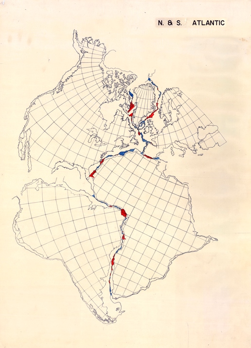
Image: The 'Bullard Fit' - Courtesy, Edward Crisp Bullard Collection, Churchill Archives Centre, Churchill College
Pivotal
Their claim became widely accepted and the paper has been lauded as one of the pivotal contributions to the emergence of the theory of plate tectonics. As of 2015, it has been cited in over 1500 different publications and Dan McKenzie2 has pointed out two particular features that account for its lasting influence. Firstly, the paper simply sets out to show how good the ‘fits’ are and secondly, the authors avoided using the ‘fits’ as an argument to support continental drift.
However, the introduction does remark that an approximate fit, especially of the coastlines of Africa and South America, had been noticed by many writers - most famously by Alfred Wegener ‘in support of his hypothesis of continental drift’, as far back as 1912. While the idea of continental drift appealed to many geologists, it was not support by geophysicists, such as Sir Harold Jeffreys, who criticised ‘the assumption that the earth can be deformed indefinitely by small forces, provided they act long enough’3.
Jeffreys, an eminent Cambridge geophysicist, also disbelieved3 the reality of the fit of South America and southern Africa. However, he based his argument on the South Atlantic’s modern coastlines, which have wide continental shelves in southernmost latitudes.
Bullard and his colleagues agreed with Jeffreys that the fit of the opposing two coastlines is neither close, nor very meaningful1. And they pointed out that, in geological terms, the real edge of the continent is the continental slope, an essential fact that Jeffreys inexplicably missed. Although Wegener had realised this geological reality, he did not pursue this vital line of inquiry. It took another 50 years before being finally and successfully pursued by Bullard, Everett and Smith.
Carey
Interestingly however, it was the work of Tasmanian geologist Warren Carey in the late 1950s that prompted Bullard to tackle the problem. As Jim Everett and Alan Smith have recently pointed out4, Bullard was impressed by Carey’s 19585 simple graphical and visual method for showing the fit of the African and South American continental margins. Using a 75cm globe with moveable hemispherical plastic caps, Carey traced the submarine contours of the continental margins onto the caps and manoeuvred them until he obtained the best fit. This was remarkably good for the 2000 m (approximately 1000 fathom) contour, which is on the steepest part of the continental slope.
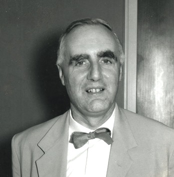 Picture: Sir Edward Crisp Bullard FRS. By permission of the Master and Fellows of St John’s College, Cambridge
The stated aim of the Bullard et al. paper was to ‘to put the facts beyond doubt by using the best data available and finding the ‘best fits’ by objective arithmetic methods’1. Bullard was a ‘fixist’ at the time and did not see how any of the then current physical models permitted continental drift. Nevertheless, he determined to resolve the question ‘just how good is the fit between South America and Africa?’4 and set his PhD student Jim Everett to find a mathematical answer.
Using EDSAC2, the early Cambridge University mainframe computer, in 1962 Everett worked from first principles of spherical geometry and wrote a program that could fit together any wiggly lines on a sphere. Everett’s ‘wiggly lines’ were of course the continental margins, and he was able to show that the 500 and 1000 fathom bathymetric contours gave good statistical fits and that of the two contours, the 500 fathom fit (c. 1000m) seemed best.
By the end of 1963 Everett had devised an iterative procedure to generate a quantified fit for the South Atlantic, with minimum least-square misfit. This fit, computed using spherical geometry, compared closely to Carey’s visual fit. And, although he was not aware of it at the time, Jim Everett had devised an application of the fixed-point theorem developed in 1775 by the famous Swiss mathematician Leonhard Euler (1707-83). Not only was it one of the first applications of the Euler theorem in this field, it also prompted a much wider use of the theorem by geologists, especially in the field of plate tectonics and continental displacement - as every first year student now knows.
However, the computed fit had to be displayed on a map, so Jim Everett had to write a second program to calculate the Mercator coordinates for the present-day geographic grid of South America rotated to its best-fit position relative to Africa. This was a laborious business. The data points had to be read off maps (from the Times World Atlas) and digitised by hand.

Picture: Alan Smith (university of Cambridge), receiving the Murchison Medal at the Society in 2008. Photo: Ted Nield
Alan Smith’s contribution to the paper was primarily concerned with the problem of extending the best fit to the North Atlantic. Smith had graduated from Cambridge (1959) in physics and geology and during graduate work at Princeton learned computer programming and been exposed to Harry Hess’s developing ideas about ocean-floor spreading. But at the time Smith was still most ‘heavily influenced’4 by Jeffreys’ apparently irrefutable arguments against the possibility of continental drift.
Alan Smith returned in 1963 to the Cambridge Department of Geodesy and Geophysics as a research assistant (to Jack Miller) to date South American and African rocks on either side of the South Atlantic, to put time-constraints on the postulated break-up these two continents and to verify the fit. But on learning of Jim Everett’s work, he became involved with applying Everett’s methodology to the North Atlantic, bringing with him some much-needed geological expertise.
Carey’s reconstruction of the North Atlantic continents was poor, largely because of geological problems, such as the question of whether Iceland should be included in any attempted fit. Smith decided to omit Iceland because of its volcanic nature, an omission that turned out to be fully justified.
Iberian correction
 Picture: Prof. Jim Everett, University of Western Australia.
In order to resolve the fit of the North Atlantic, the 500 fathom contour was first digitised on the assumption that would provide the best fit, as it had done in the South Atlantic. It did, but not without a bit more geological correction, specifically the clockwise rotation of the Iberian peninsula to close the Bay of Biscay, which was justified by palaeomagnetic evidence of a difference in magnetic declination between Iberia and Europe.
Altogether, the computed best fit of the circum-Atlantic continents clearly delineated the supercontinent of Laurasia along with the western part of the supercontinent of Gondwana. This in turn provided the foundation for the first computer-generated reconstruction of the Pangean supercontinent, although at this stage it did not include eastern Gondwana. The latter was subsequently added by Alan Smith, again using digitised data, and provided the first quantified fit of Gondwana6.
The work also led to the production in 1973 of a series of reconstructions of Phanerozoic world maps7. These computerised reconstructions have become very familiar; but few of today’s young geologists are aware of their modern scientific genesis, which owes so much to the pioneering work of Sir Edward Bullard, Jim Everett and Alan Smith.
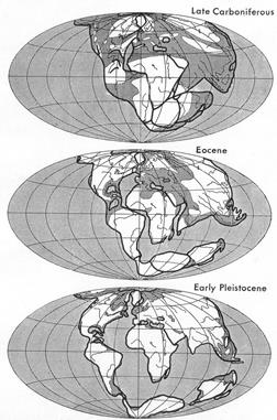 Image: Wegener's reconstruction of Pangaea, Courtesy of Dr A.G. Smith, Dept. Earth Sciences, University of Cambridge
As a postscript, it is worth pointing out that while Sir Edward had the initial idea, all the analysis was done by Everett and Smith, using the computational method designed by Everett. Fifty years ago the relative contribution to a scientific paper by the various authors was not clarified.
Acknowledgment
Douglas Palmer, author, is Public Programmes Coordinator for the Sedgwick Museum, Cambridge. He is very grateful for help in writing this account from Drs Alan Smith and Jim Everett.
References
- Bullard, E, Everett, J E and Smith, A G, 1965. ‘The fit of the continents around the Atlantic’, published in the Philosophical Transactions of the Royal Society of London, Series A. Vol. 258, No. 1088, pp 41-5.
- McKenzie, D P, 2013. ‘Rutherford’s geophysicists’. Institute of Physics, History of Physics Group Meeting, Cambridge. Abstract booklet 48pp.
- Jeffreys, H, 1924. ‘The Earth’. 1st Edn. Cambridge University Press. (4th Edn, 1959)
- Everett, J E and Smith, A G, 2008. ‘Genesis of a geophysical icon: the Bullard, Everett and Smith reconstruction of the circum-Atlantic continents’. Earth Sciences History, 27.1, pp1-12.
- Carey, S W, 1958. ‘A tectonic approach to continental drift’. In: ‘Continental Drift: A Symposium’, Carey, S W (ed.), pp177-355. Hobart: University of Tasmania Press.
- Smith, A G and Hallam, A, 1970. ‘The fit of the southern continents. Nature 225: pp139-144.
- Smith, A G, Briden, J C and Drewry, G E, 1973. ‘Phanerozoic world maps’ In ‘Organisms and Continents through Time’, N F Hughes (ed.), Joint Symposium of the Geological Society, Palaeontological Association and Systematic Association. Special Papers in Palaeontology 12, pp1-43.