Helen Quinn investigates the potential of ‘citizen science’ for geology
Early in the new millennium, the Chief Executive of Goldcorp, a Canadian gold producer, took the unusual step of making a large amount of private commercial data public. His employees thought he was mad, but Goldcorp was in trouble and facing the very real prospect of going under.
The company posted all of its data for the Red Lake mine in Ontario online - staking $575, 000 in prize money to anyone who could identify the best target for the next six million ounces of gold. This early example of crowd-sourcing was a last-ditch effort to find the gold that had been eluding Goldcorp for so long. More than 1400 scientists, engineers, and geologists from 50 countries around the world accepted the virtual exploration challenge and for Goldcorp the gamble paid off. The value of the gold discovered in the Red Lake district has so far exceeded $6 billion, helping make Goldcorp one of the fastest growing gold producers in the world.
Today, reaching out to a virtual crowd is becoming more common within the scientific community. By outsourcing tasks to an unknown, widely distributed group, crowd-sourcing can enable researchers to gain a large amount of data, often exploiting the fact that the crowd can contain more knowledge than individuals. Goldcorp’s early example of geological crowd-sourcing was a huge success but is it something that could be more widely applied in Earth sciences, and how useful are ‘citizen scientists’ in the world of geological research?
Nothing new
Citizen science is nothing new according to Dr Chris Lowry of Buffalo University, New York, who has pioneered a citizen science project, measuring water levels across different drainage basins throughout America. “Originally everyone was a citizen scientist” say Chris, “You had a job and science was on the side, at some point in history we decided to professionalise science.”
The gentlemen who found themselves dabbling in the scientific world a couple of centuries ago may have been surprised to hear themselves described as ‘citizen scientists’, but the active involvement of amateurs in science, and specifically geological sciences, is something Chris is keen to exploit. “It is the connectedness of our world that has increased these opportunities for scientists to seek help from non-specialists, and also thrown up greater opportunities. There has been a convergence between professional and citizen science, it is becoming blurred again, because citizen scientists can process and correct data.”
Data collection
The USGS has been actively encouraging ordinary citizens to get involved in their projects for over a century. The organisation, one of the most renowned mapping institutions in the world, began mapping the American continent 135 years ago. What started as mineral exploration, very quickly turned into the creation of a topographic map covering the whole of the United States of America. Today this map is known as ‘The National Map’ and although built on the mapping expertise of the USGS, the map has greatly benefited from the contributions of volunteers throughout its existence.
When the USGS began work on the National Map, it quickly realised that vast areas had to be covered and USGS employees alone could not complete the work. “We have been collecting forms for over 100 years. In the past half century we would post questionnaires and the postmaster would fill it out and return it here” says Dr David Wald, a citizen science project leader at USGS.
The postal surveys were designed to provide topographic information in areas that USGS surveyors could not practically reach, and although the best option at the time, they were for obvious reasons limited. Postmasters could not always be relied on to fill them in and the areas covered were perforce confined those connected by the postal system. Usually about a hundred surveys would come back and processing took between six months and a year. “It was a huge amount of work,” says David.
What has changed is the advent of the Internet, and mobile phones. Today we are connected like never before, so the possibility of reaching the ‘crowd’ has never been so high. For the last five years, the National Map Corps at USGS has collected all its citizen updates online. 12,000 volunteers across the country have submitted more than 25,000 data points, allowing USGS to acquire and check data from citizens with local knowledge.
For citizen science to be successful the trick is creating the right conditions to enable researchers to tap into and harness the collective knowledge out there. The USGS, with decades of mapping expertise behind it, has been able to incorporate the work of volunteers into an existing project to supplement and update its vast foundations of knowledge. The public has a very simple role - no expert knowledge is required.
Simple ideas
Having a very simple premise certainly helps when setting up this type of project. Dr Chris Lowry, in partnership with Dr Mike Fienen at USGS, is using the crowd to collect water-level data. “I like to think every American can read a ruler” Chris says, and with this in mind he realised that crowd-sourcing for extra hydrological data on his projects could become a reality. “We can’t afford to collect all this data ourselves - I needed higher resolution and lower costs; and so we realised we could put giant rulers into streams with signs saying ‘please text me the water level’.”
Chris and Mike set up a series of such rulers in streams and lakes around their study basins. “We definitely could not do this much data on this many sites using more traditional methods; we just couldn’t afford it. Economically it doesn’t make sense” says Chris.
For a project to be successful it must have a low barrier to entry. This is not because the crowd is uninterested but because people are generally busy, and if it is too much hassle people simply won’t bother. But a well thought-out simple premise can throw up surprising revelations. For Chris and Mike, the location of their ‘giant rulers’ was the key to the project’s success. Initially they went for sites with a high footfall, but surprisingly these often turned out to be sites where the lowest number of people got involved.
“We learned good lessons,” says Mike. “We thought boat landings would be a good place but the sites were horrible traffic jams, not relaxing places”. In this frame of mind people were disinclined to participate. Popular fishing spots also turned out to be unpopular for texting in data. It seems that if you are out for a relaxing day fishing, you are more likely to keep your phone off!
Chris and Mike are very keen to understand what motivates people to become involved in a scientific project. Often, mutual benefit is enough to guarantee a crowd. They have discovered that canoeists in some of their study basins actively participate, frequently texting data because canoeists themselves have found the information useful - water levels being crucial to their activities on the river. Next summer Chris and Mike hope to target such groups rather than relying on chance participation, moving from passive crowd-sourcing to actively targeting willing volunteers.
Natural crowd
In other areas of geoscience, finding a crowd is not so hard. Natural disasters automatically bring people together and regular earthquakes across the United States have provided the USGS with an already-assembled, active and connected crowd.
Last year, after a successful pilot project, USGS launched a nationwide project known as “Did you feel it?” which asks citizens to detail their experiences of any earthquakes in their area. “I call it citizen-based science: the person filling out the form just has to be an observer. Anyone who feels an earthquake can be a valid contributor” says Dr David Wald, project leader of Did you feel it?. “Mother nature shocks you into it, it’s an experience you can’t get away from. People are often truly scared, providing what you feel is a kind of catharsis, people want to share their experience and we are tapping into that.”
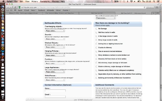
The USGS has always been a source of earthquake information for citizens of the United States. Members of the public come to their website for advice about earthquake activity in their area and while online often discover Did you feel it?. Next time there is an earthquake they are invited to submit information about their experiences. By answering questions such as: If you were sleeping, did it wake you? Was there any damage to your building? and: Did pictures on the wall move or get moved askew?
Citizens are thus able to contribute actively to USGS’s knowledge of earthquakes around the United States. The questions are designed to be diagnostic of earthquake intensity and the citizen response, through the application of a simple algorithm, can be translated into a quantitative intensity as measured on the Modified Mercalli Intensity Scale. The translation of citizen observations to quantitative data is an important step forward in citizen science, which has mostly relied on simple qualitative observations in the past.
One of the quirks of Did you feel it? is that citizen information, via text and the Internet, often get to the USGS faster than the seismic measurements. “It is a unique form of traffic, everyone feels it at the same time and people feel connected and get online. Now we have a much better sampling reach, a better volume; we had around 150,000 responses to the Virginia earthquake [in 2011] and 80-90% of these were in the first hour” says David.
Because large magnitude earthquakes are fairly rare along the East Coast, there were only a small number of seismometers installed nearby to record the Virginia earthquake event; citizen scientists therefore provided much of the preliminary data for this earthquake. “It’s almost more than we can do to keep up with this growth; now it’s orders of magnitude higher, we have higher population and huge Internet growth. It’s a game-changer. We just can’t collect that amount of data. We scratch the surface with our own resources.”
Data acquired from citizens is regularly tested against data from the USGS seismic stations to ensure errors are minimal. These types of checks are being repeated in other studies such as Chris Lowry and Mike Fienen’s hydrological project, where checks using pressure transducers and USGS borehole data provide error measurements of less than 200th of a foot (an increment of their giant rulers) for every measurement. This gives researchers confidence that this type of controlled volunteer participation can add scientifically valid data to existing projects.
Global engagement
Closer to home the British Geological Survey have at least seven scientific projects in which they work with citizen scientists. From soil studies, to flooding and earthquakes to landslides, the BGS is actively engaging with the British public. “I am really enthused,” says Professor Mike Stephenson, Director of Science and Technology at BGS. “For us it would be madness not to take into account what people observe. There are lots of feet on the ground and lots of eyes out there - it would be just nuts not to use it. We have very much bought into the idea of citizen science and crowd-sourcing, I don’t think we could operate without it.”
Interestingly the BGS has actively encouraged citizens to go beyond simple observations and to collect samples. Keen amateur volcanologists can send in ash samples to help scientists understand the distribution of ash-fall after major volcanic events such as the Eyjafjallajökull in 2010 and Grímsvötn in 2011. All of this can be done via a smartphone app known as myVolcano, which guides volunteers through the process of collecting images, samples and data, while also providing the user with information and education about volcanoes around the world.
The volcano project is being undertaken on a worldwide basis, in conjunction with the Smithsonian Institute in Washington, and like many of the BGS’s citizen science projects there is a real feeling of global reach. Mike is keen that BGS projects continue to go beyond the shores of the UK and is excited about the collaboration with aid agencies around the world, potentially making disaster relief increasingly accessible and more quickly available.
Worldwide projects come with their own problems, not least border and language issues; but by bringing crowds together on a worldwide stage there is even more potential to gain from the crowd’s collective knowledge. “It’s the size of the information out there. It’s wonderful to develop relations with citizen scientists out there and use these things. Astronomy has been doing it for a while, why is geology any different? It’s a very exciting time,” says Mike.
Not all of BGS’s public participation projects have so far met with unqualified success however. Its GeoExposures website, which aims to allow citizens to record temporary exposures, has logged only 13 such exposures in the five years since its inception. These entries are of high quality, but it appears that the level of specialist technical knowledge required is simply too high for it to qualify as a true ‘crowd source’ project. While the community appears keen in theory, reactions seem to bear this out: “The activation energy required is simply too high” one amateur field geologist confided. The USGS’s view about ‘low barriers to entry’ seems to be right on the money.
Awareness
Undertaking citizen science can be quite unlike traditional methods of research and as a result it has sometimes jarred with the scientific community. But, with high levels of accuracy being recorded and awareness growing, the possibilities for supplementing core research are huge. At the heart of all citizen science projects lies the active involvement of amateurs in the work of the scientific community. Technology has made some of these connections feasible, but it is the human behaviour that technology enables that makes crowd-sourcing such an exciting option. Scientific projects are capitalising on a much more connected world and our deeply ingrained social nature, offering exciting possibilities for the geological sciences.
As Mike Fienen reflects: “I really love the idea of people engaging in science even if they are not ‘experts’. Whenever the general public and scientists come together strongly it’s a way to engage and interact with the environment. I love the idea that people feel engaged with the environment around them and it’s a clever way to get more data, but more important it is that engagement.”
*
Helen Quinn, who studied geology at Edinburgh University, works in the science department at the BBC.