Phil Heron & Ed Garnero review the mysterious seismological features that exist near the core-mantle boundary
Heron, P. & Garnero, E., What lies beneath: Thoughts on the lower mantle.
Geoscientist 29 (3), 10-15, 2019
https://doi.org/10.1144/geosci2019-015;
Download the pdf here
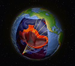 Left, Cartoon of seismic waves interacting with tomographic images (© Ed Garnero)
The theory of plate tectonics has been in the mainstream of science thinking for the past 50 years. With greater knowledge of the life cycles of ocean basins came the understanding that Earth’s surface could move and interact with convection currents within the mantle (as discussed by Arthur Holmes 20 years earlier). Yet, our understanding of mantle convection remains enigmatic. Questions persist on a number of fundamental topics, ranging from the origin of large igneous provinces to whether the mantle is compositionally heterogeneous.
Given our research interests—Phil Heron researches how the deep mantle can influence and be influenced by plate tectonic processes at the surface, while Ed Garnero is a leading seismologist working on Earth and planetary interiors—we decided to team up to review and summarise current understanding of what lies deep beneath our feet.
We find that our understanding of the deep Earth has taken great strides in the past century and it’s now clear that mantle structure is far more complex than previously thought. However, despite advances in analytical techniques and increased data volumes, the causes of this structural complexity and links with mantle dynamics and plate tectonics remain open questions.
Data prevalence
The prevalence of new data from oceanic basins in the 1960s bolstered the acceptance of the theory of plate tectonics; the rise of sonar technology during World War II enabled mapping of the seafloor, which, when coupled with the use of magnetic data, led to an understanding of new ocean basins being formed and destroyed. Geodetic measurements of Earth’s surface confirmed plate tectonic theory—the rise of Global Positioning Systems over the past two decades allowed for increased insight in plate motion and strain accumulation across faults. Yet, while ocean data in the 1960s helped to produce a golden decade of discovery on how Earth’s surface moves, our understanding of Earth’s interior has progressed at a slower pace.
Seismic tomography provides our best field trip into the deep mantle. Earthquakes release energy in the form of P- and S-waves that travel around and through the globe. This (seismic) energy is recorded by seismometers on the surface and capture the internal properties of the material the waves have passed through (tomography). Using mathematical modelling of the seismic wave travel times from source (earthquake) to receiver (seismometer), the speed of the wave at different positions in the mantle can be estimated. The varying speeds give indications of different properties within the interior. Such calculations are computationally costly and require a large database of ground motions that record earthquake shaking (seismograms) on a global scale. However, recently there has been a boom in seismic tomography studies that is linked not only to improved analytical techniques and availability of computational power, but also to an increase in the number of high-resolution large-scale seismic arrays used to generate a clearer image of the Earth.
An example of such an endeavour is the 15-year programme of USArray (initiated by EarthScope;
www.earthscope.org) whereby temporary and permanent seismic stations were deployed across the USA (consisting of a Transportable Array, a Flexible Array, a permanent reference network and a magnetotelluric facility). The Transportable Array is a network of 400 high-quality seismographs placed at a 70 km spacing for two years at a time, moving across the United States from east to west (Fig 1). The spacing of the seismographs allows for improved mapping of the structure of Earth’s interior, as subtle seismic anomalies found in data from distant earthquakes can now be described with greater confidence, owing to the vast data abundance and wave sampling density that enhances coherent signal energy in stacking procedures.
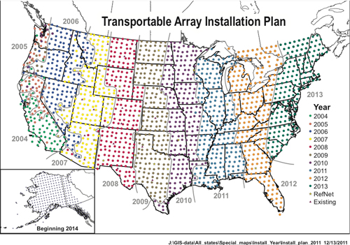 Figure 1, Map showing the unprecedented seismometer coverage of the Transportable Array Stations for the USArray project. Credit: IRIS (www.iris.edu).
Deep mantle blobs
Seismic tomography has given us a window into the deep mantle where standard field trips cannot take us (Fig 2). Adam Dziewonski and Don Anderson produced the first global seismic tomography model 35 years ago, which promised to “answer some basic questions of geodynamics and signify a revolution in earth science” (Scientific American 1984). Although we’ve made progress, there are currently more questions than answers. Over the years, vastly increased amounts of seismic data have sharpened the focus on structures through which seismic waves travel anomalously fast or slow compared to the surrounding ‘normal’ mantle (Fig 2). Such structures are found at all depths, ranging from within the mantle lithosphere, as summarised brilliantly in Emily Hopper and Karen Fischer’s paper ‘The meaning of midlithospheric discontinuities: A case study in the northern U.S. craton’ (G-cubed 2015), to the lower mantle where Dan A. Frost and colleagues describe 4 to 6-km-wide anomalies interpreted as crust in the deep mantle (EPSL 2017).
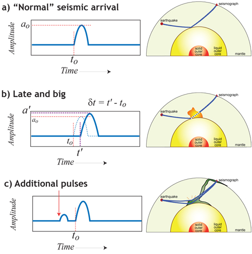 Figure 2, A schematic to illustrate travel-time perturbations due to some internal anomaly, and extra (unanticipated) energy due to the internal reflection of energy (© Ed Garnero).
For the past 15 years, two massive structures imaged by global seismic tomography models have caught the attention of the geodynamics community and generated a fiery debate on the very fabric of mantle convection—a debate that does not appear to be cooling any time soon. Figure 3 shows a horizontal cross-section of a global seismic tomography model depicting the relative variations in shear velocity (with respect to the mean) at 2,800 km depth in the mantle. Near the core–mantle boundary, anomalously warm material (characterized by low shear wave velocities) is present beneath the Pacific and African plates, with the latter lying below the site of the last supercontinent Pangaea. These features are described as “continental in size and (at certain points) 100 times higher than Mt Everest” in Ed Garnero’s recent TEDx talk on the matter.
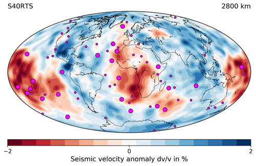 Figure 3, Tomography depth slice at 2800 km for model S40RTS (Ritsema et al., J. Geophys. Res. 1999), generated using SubMachine (Hosseini et al., G-Cubed 2018; CC-BY 4.0). S-waves travel slowly through red and quickly through blue material. Large slow anomalies exist beneath Africa and the Pacific. Pink circles, hotspot distribution (Steinberger, J. Geophys. Res. 2000). Larger circles, hotspots linked to the deep mantle (French and Romanowicz, Nature 2015).
As shown in Figure 3, the two regions are characterized by lower than average shear wave velocities. As a result, they are widely known as large low shear velocity provinces (LLSVPs). The acronym LLSVP, although being descriptive, is often thought of as cumbersome by the geodynamics community. Despite this, renaming has gained little traction, with ‘blobs’ or ‘slobs’ (slow blobs) not widely used. At the Study of the Earth’s Deep Interior conference (SEDI) in Edmonton, Alberta in 2018, John Hernlund (Earth-Life Science Institute, Tokyo Institute of Technology) addressed this issue and proposed a new, more easily-to-pronounce acronym of PADSS (Pacific African Deep Seismic Structures). Will the description take hold? Time will tell.
Nomenclature aside, the major discussion points regarding LLSVPs cover pretty much every aspect of their nature: composition, longevity, shape, and origin.
Composition and longevity
A review paper by Ed Garnero and colleagues (Nature Geoscience, 2016) provides a summary of the different interpretations of LLSVPs, which we’ll explain here.
The first interpretation is that the LLSVPs may not be the structures we perceive them to be. Indeed, we are looking at something that is thousands of kilometres away and require earthquake waves to image—it may be that our resolution of the mantle at depth is not as good as we think, and we ‘see’ a smudged picture of what is really there. There is a strong case that these blobs are just thin, thermal plumes with smeared resolution at depth (Fig 4b).
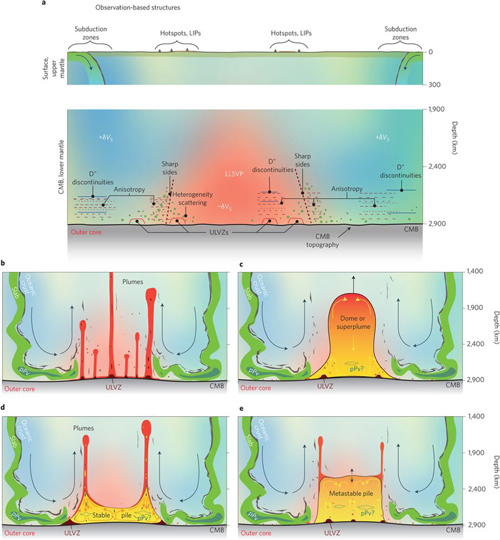 Figure 4, a, Surface features (upper panel) and seismically determined lower-mantle phenomena (lower panel). b–e, Idealized possibilities to explain LLSVPs (surrounded by subducted material) b, Plume cluster. c, Thermochemical superplume. d, Stable thermochemical pile. e, Metastable thermochemical pile. LIPs, large igneous provinces; CMB, core–mantle boundary; ULVZs, ultra-low velocity zones. Reprinted by permission from SpringerNature: Garnero et al., Nature Geoscience 9, 481-489 © 2016)
The second interpretation is that these blobs are huge super plumes or domes of hot material lying beneath the Pacific and Africa. These hot structures rise and fall over time and interact with the cold mantle ‘oceans’ that surround them (Fig 4c).
At the other end of the scale, it has been suggested that these blobs are more stable structures, made of a dense material that is distinctive from the surrounding mantle (Fig 4d). The stable structures interact with the ancient subducted oceanic lithosphere that butts up against the edges of the piles, but the blobs remain fixed in their position for hundreds of millions of years. The stability of the piles of material produces super volcanoes, in the form of large igneous provinces, mainly from their edges, and are a dominant force in mantle dynamics.
The fourth interpretation is a softer version of the latter—that these blobs are distinctive piles of dense material, but are ‘meta-stable’ in nature, and have steep, vertical sides (Fig 4e). In all scenarios, the subduction of oceanic lithosphere can interact with the blob material to produce super volcanoes through mantle motion. Depending on the rheological strength of the LLSVP, it may be that the ancient oceanic lithosphere can act as a broom to push the blobs into piles at certain geographical locations. In this case, where the strength of oceanic lithosphere is more than the LLSVPs ability to resist lateral motion, the landscape of the deep mantle may evolve over time similar to plate tectonic evolution at the surface.
The diversity of these interpretations throughout the geophysics community highlights the difficulties in constraining mantle dynamics. Indeed, early studies using tomographic normal model data argued that the two deep anomalies were characterized by higher-than-average densities (e.g., Ishii & Tromp, Science 1999), whereas a study using Stoneley mode data found that LLSVP regions show lower-than-average densities (Koelemeijer et al., Nature Communications 2017). Instead of a density difference, seismic observations from the lower-most mantle could also be explained by compositional heterogeneities and/or a post-perovskite phase change (e.g. Trampert et al., PEPI 2001). Furthermore, the possibility that LLSVPs are purely thermal plumes has been put forward (Schubert et al., PEPI 2004), with numerous studies highlighting that the low tomographic resolution in the deep mantle may smear our view of the geodynamic features (e.g. Ritsema et al., J. Geophys. Res. 2007; Davies et al., EPSL 2012).
Dynamics
Despite uncertainties about the composition of the LLSVPs, what seems to be settled in the geodynamic community is that mantle plumes can originate from the LLSVP regions through one mechanism or another (e.g. Torsvik, et al., EPSL 2008; Torsvik, T. & Cocks, L.R.M. Cambridge Press 2016). Positions of present-day hotspots and ancient large igneous provinces appear to occur in the vicinity of LLSVPs (Fig 3).
A key unresolved question is how LLSVPs interact with mantle dynamics over geologic timescales, especially the large-scale downwelling related to supercontinent formation. Thermochemical geodynamic models show that it is difficult to generate positionally stable LLSVPs on timescales greater than 300 million years. In general, the geodynamic consensus is that downwellings that reach the core–mantle boundary may sweep aside thermochemical LLSVPs so that the current shape of the LLSVPs may be due to Earth’s subduction history moulding the anomalies.
A wider point is the origin of such LLSVPs. Have they have accumulated over time or are they primordial in nature (Fig. 5)? The origin of these features may impact the perceived long-term stability of the piles. One hypothesis is that LLSVPs are an accumulation of subducted oceanic material built up since the beginning of plate tectonics. Another idea is that LLSVPs are a remnant of a magma ocean or differentiation during the planet’s formation. The long-term stability of the piles in their current position is used as evidence to support both the accumulation and primordial scenarios—the antipodal positioning of the African and Pacific LLSVPs represents the optimal momentum of inertia, so could explain why the deep structures are stable in the spinning Earth.
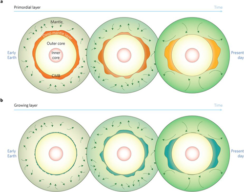 Figure 5, Two end-member evolutionary pathways for a present-day thermochemical pile. a, Primordial layer: early Earth processes establish a global layer, which develops into separate piles over time. b, Growth of the thermochemical layer: material with elevated density collects at the core–mantle boundary, grows into a thicker layer and eventually into distinct thermochemical piles. Reprinted by permission from SpringerNature: Garnero et al., Nature Geoscience 9, 481-489 © 2016)
Shape
The rise of seismic vote maps has helped clarify where the community stands on what we are imaging in the lower mantle. As described by Grace Shephard and co-authors (Scientific Reports 2017), vote maps are generated from stacking tomography models and identifying where the models agree based on an increasing vote count at a specified depth. Comparing where the different seismic tomography models agree gives an indication of the probability of LLSVPs inhabiting a particular area of the mantle. A very useful resource is the website SubMachine (
http://submachine.earth.ox.ac.uk) which is “a collection of web-based tools for the interactive visualisation, analysis, and quantitative comparison of global-scale, volumetric (3-D) data sets of the subsurface”. Setup by Kasra Hosseini, Kara Matthews and Maria Tsekhmistrenko, SubMachine can show the vote maps for fast and slow tomographically determined seismic velocities at all depths.
Applying this to the 2,800 km depth shows the relative agreement between the models for LLSVPs, with some features being more common than others (Figure 6). For instance, the small seismic anomaly beneath Eurasia dubbed the Perm anomaly. Recent studies, including that by Long and Lynner (Geophys. Res. Lett. 2015), show that the Perm may be compositionally similar to the African LLSVP, raising further questions on the dynamics of the lower mantle. Could a small pile of an LLSVP be separate or must it be attached to the large African LLSVP?
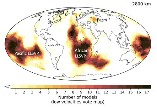 Figure 6, Tomographic shear wave vote map at 2,800 km depth for 17 global models, generated using SubMachine (Hosseini et al., G-Cubed 2018; published under a creative commons licence, CC-BY 4.0). Image shows areas where S-wave models travel slowly through material, the more votes the more models that agree there is an anomaly present.
A 2015 Nature paper by French and Romanowicz featured mantle imaging that encapsulated the full seismic waveform, allowing for increased resolution. Their paper discussed the LLSVP shape and found a clear difference in Pacific and African morphology—the African LLSVP presents as a broad dome and the Pacific presents as more of a cluster of broad plumes. As more data becomes available and further analytical techniques, such as full waveform tomography, are developed, our idea of what LLSVP are and what shape they take in the present-day, may change dramatically.
Discovery
The remaining mysteries of our planet will no doubt drip out a lot slower than the 1960s revolution—fifty years ago new data arrived following giant technological advances, but present data improvements are more incremental (and at the whims of the available funding that drives scientific discovery). Our understanding of the interior of the planet has changed dramatically over the past 100 years (Fig 7), but there are a number of processes that we still do not fully understand. Earth has yet to reveal all its secrets, but every day a new earthquake shines a light on the deep that, through seismic interrogation, help us better understand our planet.
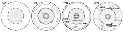 Figure 7, Summary of how far we have come in over 100 years of studying the interior of the Earth. (© Ed Garnero).
Affiliations
Philip J. Heron, Marie Skłodowska Curie Research Fellow, Durham University; e-mail:
[email protected]
Edward J. Garnero, Professor, Arizona State University.
Further reading
Phil has a review paper ‘Mantle plumes and mantle dynamics in the Wilson Cycle’ in the Geological Society Special Publication, Fifty Years of the Wilson Cycle Concept in Plate Tectonics that features LLSVPs;
https://doi.org/10.1144/SP470.18.
Ed has a recent TEDx talk ‘An Amazing Look into the Center of the Earth’;
https://www.youtube.com/watch?v=2qOcedUi0EI
References
Anderson, D.L. & Dziewonski, A.M. (1984) Seismic Tomography. Scientific American 251 (4), 60-71.
Davies, R.H. et al. (2012) Reconciling dynamic and seismic models of Earth's lower mantle: The dominant role of thermal heterogeneity. Earth and Planetary Science Letters 353–354, 253-269.
French, S.W. & Romanowicz, B. (2015) Broad plumes rooted at the base of the Earth’s mantle beneath major hotspots. Nature, 525, 95–99,
https://doi.org/10. 1038/nature14876
Garnero, E.J., McNamara, A.K. & Shim, S.-H. (2016) Continent-sized anomalous zones with low seismic velocity at the base of Earth’s mantle. Nature Geoscience 9, 481–489;
https://doi.org/10.1038/ngeo2733
Heron, P. J. (2018) Mantle plumes and mantle dynamics in the Wilson cycle, from: WILSON, Houseman, R.W. et al. (eds) (In Press) Fifty Years of the Wilson Cycle Concept in Plate Tectonics. Geological Society, London, Special Publications 470.
https://doi.org/10.1144/SP470.18.
Hosseini, K. et al. (2018) SubMachine: Web-Based tools for exploring seismic tomography and other models of Earth's deep interior. Geochemistry, Geophysics, Geosystems 19; doi:10.1029/2018GC007431
Ishii, M. & Tromp, J. (1999) Normal-Mode and Free-Air Gravity Constraints on Lateral Variations in Velocity and Density of Earth’s Mantle. Science 285, 1231-1236.
Koelemeijer, P et al. (2017) Density structure of Earth’s lowermost mantle from Stoneley mode splitting observations. Nature Communications 8, 15241
Long, M.D. & Lynner, C. (2018) Seismic anisotropy in the lowermost mantle near the Perm Anomaly. Geophysical Research Letters 42, 7073-7080.
McNamara, A.K. (2018) A review of large low shear velocity provinces and ultra low velocity zones. Tectonophysics,
https://doi.org/10.1016/j.tecto.2018.04.015
Ritsema, J. et al. (1999) Complex Shear Wave Velocity Structure Imaged Beneath Africa and Iceland, Science 286, 1925-1925.
Ritsema, J. et al. (2007) Tomographic filtering of geodynamic models: Implications for model interpretation and large‐scale mantle structure. Journal Geophysical Research-Solid Earth 112,
https://doi.org/10.1029/2006JB004566
Torsvik, T. & Cocks, L.R.M. (2016) Earth History and Palaeogeography. Cambridge University Press;
https://doi.org/10.1017/9781316225523
Torsvik, T.H. et al. (2008) Longitude: Linking Earth's ancient surface to its deep interior. Earth Planet Science Letters 276, 273-282.
Trampert, J. et al. (2001) Sensitivities of seismic velocities to temperature, pressure and composition in the lower mantle. Phys. Earth Planet. Inter. 124, 255–267.
Schubert, G. et al. (2004) Superplumes or plume clusters? Phys Earth Planet Inter. 146, 147-162.