Gaping Gill
Yorkshire Dales, England
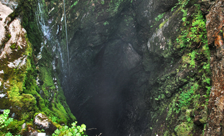
'Gaping Gill in the Dales where Fell Beck becomes Britain's highest unbroken waterfall'
From @Jamie_Woodward
'A huge cavern underneath Ingleborough, 100m from moor to the floor (although there are many tens of meters of cobbles below), and big enough to fit a small cathedral inside.'
From Alan J. Wylie on Facebook.
Gaping Gill (also known as Gaping Ghyll) is a spectacular natural cave in North Yorkshire, England. On the southern slope of Ingleborough it is a 98-metre (322 ft) deep pothole with the stream, Fell Beck, flowing into it. After falling through one of the largest known underground chambers in Britain, the water disappears and eventually resurges adjacent to Ingleborough Cave.
Geology
The Ingleborough area is part of a limestone region which lies on the southwest edge of the Askrigg Block, an uplifted area bounded by the Dent Fault to the West and the Craven Fault to the South West and dipping at just a few degrees to the N.N.E.
The limestone, known as the ‘Great Scar Limestone', was laid down as a sediment, almost 200 m. thick, in a warm tropical sea, about 350 million years ago during the Lower Carboniferous period (Dinantian) when Europe and the British Isles lay about 10⁰ south of the equator. The remains of sea creatures formed the sediment, of typically 95% pure calcium carbonate, deposited on a sea floor comprised of impermeable, strongly folded slates and greywackes of Lower Palaeozoic Age. The limestone contains the fossils of corals, brachiopods and crinoids.
The Ice Age Changes
Climatic change, starting during the Pleistocene period led to the formation of glaciers in the more northern parts of Europe. The land was scoured and deep north-south aligned valleys formed on the surface.
At the end of an Ice Age the retreating ice sheet released vast quantities of melt water. New surface features were cut into the limestone landscape and new cave systems were developed, often at a lower level than previous ones, because the local water table level had been lowered by the deepening of the valleys.
Development of Cave Systems
Surface streams draining off the peat are mildly acidic in nature with a typical pH <5. Atmospheric carbon dioxide, surface vegetation, peat and similar organic material give rise to the acidic waters which dissolve the limestone rock. The primary permeability of the limestone is very low, but the cracks and fissures in the limestone allow the water to penetrate. Initially the water seeped into vertical joints or fault fissures, dropping down to the water table level and then along weaknesses or ‘bedding planes’ between the beds of submerged limestone.
The first recorded attempted descent was by John Birkbeck in 1842, who reached a ledge approximately 55 metres down.
Related Links
Images (top to bottom):
- Looking down into Gaping Gill © Wojciech Rozanski (Source Geograph.org.uk) Creative Commons Attribution-ShareAlike 2.0 license.
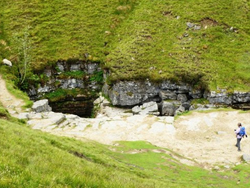
- Gaping Gill © Andy Jamieson (Geograph.org.uk) Creative Commons Attribution-ShareAlike 2.0 license.
![]()
October 13 - 21
Theme: 'Earth Science in our lives'