Cromer Glacio-tectonic Folds
Norfolk, England
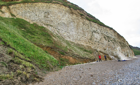
The sea cliffs at Overstrand near Cromer in North Norfolk [NGR TG 256 405] on the north coast of East Anglia are one of the classic sites in Britain for seeing first-hand the scale of deformation which can be caused by glaciers and ice sheets.
 This deformation, known by earth scientists as “glacitectonism”, occurs on a variety of scales from delicate micro-scale structures which can only be examined under the microscope, to much larger features on the order of 10’s to 100’s of metres in scale. Glaciers are highly dynamic systems ‘pulsing’ or ‘oscillating’ as they advance or retreat, leaving behind an often complex array of sediments, landforms and deformation structures which can provide a detailed record of their growth and eventual demise.
The large-scale glacitectonic deformation seen at Overstrand was formed during the Anglian glaciation about 450 thousand years ago (Middle Pleistocene) by a major ice sheet flowing down the North Sea from the north, that pushed into and overrode a sequence of glacial and pre-glacial sediments which mantle the Cretaceous chalk bedrock of this part of eastern England.
As it advanced towards what is now the coast of North Norfolk the ice detached a number of large, slab-like blocks composed of chalk and the overlying shallow marine sands and gravels belonging to the pre-glacial Wroxham Crag Formation. The ice transported these blocks, which are also known as “glacial rafts”, for up to several hundred metres, before stacking them into the glacial sediments being laid down at its margin.
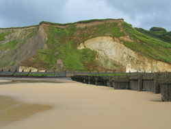 The main glacial raft at Overstrand is approximately 20-25 m thick and over 100 m in length, and dips at between 20° to 30° towards the north. Although deformed by the ice, the original bedding within the chalk is clearly preserved by bands of nodular flint. Towards the southern end of the raft, this bedding is folded by an open, asymmetrical monocline which formed as the chalk was being pushed southwards by the ice.
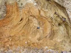
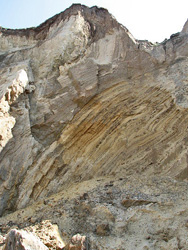
The base of the raft is formed by a prominent low-angle fault or thrust which separates the chalk from an underlying sequence of bedded, red-brown sands and gravels. These sediments were locally tilted and folded during the emplacement of the overriding glacial raft. Immediately adjacent to the base of the chalk, bedding within sands and gravels has been destroyed due to the intense deformation accompanying movement along the thrust at the base of the raft.
The spectacular glacial rafts at Overstrand form part of a complex, variably deformed sequence of glacial sediments exposed along the North Norfolk coast which record the repeated inundation of this part of eastern England by ice during the Middle Pleistocene Anglian glaciation.
Text: Emrys Phillips (British Geological Survey)
Related Links
Images (top to bottom):
- Chalk Raft at Overstrand © Emrys Phillips (British Geological Survey)
- Small scale deformation of sand below chalk raft © Emrys Phillips (British Geological Survey)
- Cliffs showing chalk raft deformed into monocline © Emrys Phillips (British Geological Survey)
- Deformation in sediments © Evelyn Simak (Source Geograph.org.uk) Creative Commons Attribution-ShareAlike 2.0 license
![]()
October 13 - 21
Theme: 'Earth Science in our lives'