As Hull, 2017 City of Culture, takes centre-stage, Ellen Spencer* shines the spotlight on saline intrusion in the Chalk aquifer.
The Yorkshire Chalk aquifer provides an essential resource for freshwater supply. In Hull this has been under threat since the industrial revolution, as historic abstraction of groundwater has caused influx of saline water from the Humber Estuary. Research in the late 1980s showed the Hull saline intrusion had probably stabilised - the likely cause being a decline in industrial abstraction, along with enforced reduction in private groundwater abstraction in the city. Yorkshire water also implemented sustainable public water supply (PWS) abstraction management. But what is the situation 30 years on? Yorkshire Water, working in collaboration with the Environment Agency (EA), Arup and Leeds University, set out to update historic research.
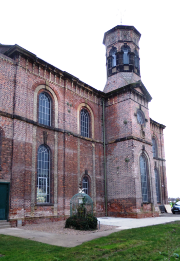
Picture: Springhead Water Works – recently restored to former glory
A watery history
The monks from Meaux Abbey chose the confluence of the River Hull and the Humber Estuary as a port for exporting wool sometime in the 12th Century. The town, renamed Kingston-Upon-Hull by Edward I In 1299 has maintained its special relationship with the sea throughout history, as a trading hub, fishing and whaling centre, military supply port, and industrial centre. The new Green Port Hull development, home to the Siemens offshore wind-power facilities, aims to put the city at the forefront of the renewable energy sector and earlier this year saw a milestone reached when the first turbine components were shipped out
In recent decades the main problem for Hull has been too much water, with a number of serious flooding incidents; but throughout history, Hull has also had its fair share of problems with freshwater supply.
The first records of ‘public water supply’ date from 1292, for a spring on the site of what is now Springhead pumping station. This fed water to Ferriby, but the dyke was diverted to supply the growing settlement of Hull. Residents of surrounding villages were not happy with this, and laid siege to Hull and filled in the dykes. The siege failed (and some of the attackers were hanged in York!)
Further disputes arose with ‘stinking carrion’ being tipped into the freshwater dykes. This only ended in 1412 with a letter from the Pope exhorting peace, with threats of doom to those who did not comply. Around 1842 the River Hull was briefly used for water supply, but the water quality was poor even after treatment.
After a cholera outbreak in 1849 a local man, William Warden, challenged the view about groundwater and won a competition to improve the spring supplies at Springhead. Eventually a 3km-long system of shafts and adits was constructed, with pumping engines starting up in 1864 to great success. Springhead pumped to treatment works at Stoneferry and many of the spring ditches were infilled. Over the coming years, further Chalk adit systems were developed on the outskirts of Hull, the biggest of which is still located at Cottingham.
Hull’s water supply is still dominated by abstraction from the Chalk aquifer. Four sites on the peri-urban fringes of Hull (Springhead, Cottingham, Keldgate and Dunswell) now feed a large modern treatment works producing up to 90 million litres a day, supplying a population of 258,995 and many large businesses.
Yorkshire Chalk aquifer
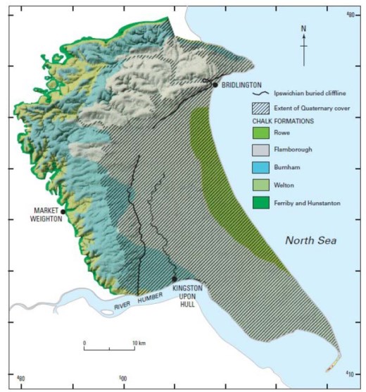
The Yorkshire Chalk north of the River Humber underlies an area of some 1800 km
2 (right). The Chalk consists of the Ferriby, Hunstanton, Welton, Burnham, Flamborough and Rowe Chalk formations. It outcrops to the west in a crescent-shaped belt of hills - the Yorkshire Wolds - rising up to 240m AOD. These are incised by a network of relict steep-sided, narrow valleys, most of which are perennially dry.
Picture above: Yorkshire Chalk and the location of the palaeo cliff line. Taken from Gale and Rutter (2006)
The Wolds reflect the Chalk outcrop of an open south-easterly plunging syncline. The Chalk aquifer is unconfined in the upland Wolds, where the majority of recharge occurs. It becomes semi-confined on the lower-lying parts of the dip slope where it is covered by thickening low permeability Quaternary superficial deposits, which quickly fully confine the Chalk towards the east and form the low-lying Holderness plain.
It is generally believed that during the Ipswichian marine transgression the sea cut a coastline in the Chalk from Bridlington, running inland via Great Driffield and meeting the Humber Estuary east of Hessle. The cliff was buried by glacial deposits and now resides above the present shoreline. Natural groundwater discharge occurs along the edge of the glacial deposits and base of the Chalk escarpment. Most drainage is in an easterly or southern direction towards lower lying areas, where water discharges as artesian outflows between the buried cliff line and the River Hull. In the north there is direct flow towards the North Sea.
Saline intrusion
As is clear from the water supply history, artesian conditions were present around Hull in the 19th century, resulting in an area of freshwater discharge via springs and artesian flowing wells. Springs were also recorded along the Humber Estuary, at Hessle Whelps, near the current location of the Humber Bridge. Anecdotal reports of fishermen lowering buckets into the estuary and drinking the water, also suggest springs existed there.
Heavy exploitation of the Chalk aquifer during the 19th and 20th Centuries caused a substantial lowering of groundwater levels, and many springs and areas of freshwater discharge in the Humber Estuary stopped flowing. Hydraulic gradients reversed and saline water from the estuary intruded into the Chalk at this time. The problem of saline intrusion in Hull was apparent in the 1880s, when a public water supply borehole near to West Park was lost due to poor quality.
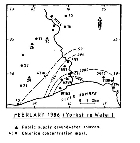
The first comprehensive study of the origins and dynamics of the saline front was published by Foster et al. in 1976. Chloride, commonly used as a salinity indicator, would be expected to be <20mg/l in fresh Chalk groundwater, and is typically around 40,000mg/l in seawater. Chloride concentrations in Hull, towards the estuary, were found to be around 10,000mg/l, with high concentrations intruding inland. Following the introduction of abstraction management schemes, in 1986 Chadha reviewed additional data and confirmed that the saline front was at least stable, if not in retreat towards the shore.
Picture left: Isochlor map, from Chada 1986.
Historic studies went some way to identifying at least two sources of saline groundwater in the Yorkshire Chalk, modern and ancient - both related to seawater intrusion. The former was associated with anthropogenic groundwater abstraction, while the latter related to at least one interglacial marine transgression where the existing ground surface was submerged below sea level.
In Hull there is strong timeline evidence to suggest that the highly saline water is sourced from anthropogenic abstraction-induced intrusion. However, it is still possible that there is also ancient saline water, as seen in other areas of the Yorkshire Chalk, mixing with the modern saline water in Hull. Despite continued restrictions on abstractions in Hull, only a handful of studies has looked at the problem since Chadha’s work.
Refresh needed
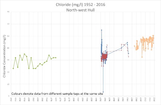
If saline intrusion had really halted back in the 1980s, recent concentrations of chloride at Yorkshire Water abstraction sites on the outskirts of Hull may have been expected to have stabilised or declined; however, such was not found to be the case <Fig 3>. Although water quality at the PWS is well within drinking water standards and not considered saline, the rising trend raises the question as to whether the saline front is indeed stable.
Picture: Cl time series for YWS sites showing rising trend
Due to the location and sensitivity of their groundwater abstraction sources, Yorkshire Water recognised the need to investigate the current and likely future status of saline intrusion. The EA also recognised the need to further understanding of groundwater quality across Hull. A joint programme of work was agreed to understand risk to abstraction and to inform future management decisions so as to ensure that water supply was protected, abstraction was sustainable and the Water Framework Directive duly complied with.
Everyone recognised that - not only was there a gap in the record of water quality monitoring up to recent times, but that previous studies had not looked at the vertical water quality profile in the Chalk, or attempted to evaluate the influence of different sampling methods, differing borehole installations, and in some cases, seasonal or tidal influences in the datasets. Working with the EA (under the National Environmental Programme) the team set out to build an improved sampling network for long-term monitoring of the aquifer.
Seek and find – or not
A desk study and audit of boreholes was undertaken, to establish a useable existing monitoring network in and around Hull. Because of the moratorium on new abstractions, and the saline water in the city, few groundwater abstraction sites were left to sample. This was a problem, as the regional study would need a good spread of spatial data in order to allow full understanding of the issues and comparison with historic results.
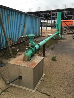
The EA’s only remaining long term water quality monitoring borehole in Hull, near Joint Docks (
Picture, left), was due to be decommissioned. Building a relationship with the new site owner was prioritised in order to save the best long-term monitoring site available to the team. Other companies and private abstractors in Hull were contacted in order to try to locate and preserve historic boreholes, which might be developed as monitoring sites.
Hull Truck Theatre is one such site where co-operation from the owners has been crucial. Well known as the home of John Godber during the 1980s and 90s, and hit plays like ‘Up n Under’, the theatre is now hosting the main drama events of Hull UK City of Culture 2017. It is also one of the few remaining licensed abstraction sites in central Hull. Groundwater is used here for an open-loop geothermal system providing an energy efficient way of cooling the theatre (representing an emergent new use of groundwater in the UK).
Infrastructure and building schemes across Hull were also reviewed in our attempt to track down any further site investigation wells still in existence across the city that might be incorporated into the saline monitoring network. The A63 Castle Street scheme <Photo 4> has provided excellent monitoring data and installations, which can be adopted for future use. Yet despite all this, large gaps still existed in the monitoring network.
Investigation
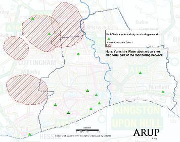
Siting new long-term monitoring boreholes in a built-up urban area (
Picture, right) is no simple task. With budget for just four boreholes, it was essential that they were located where they would provide the most valuable information. They needed to fill spatial gaps between the existing monitoring network and PWS, and also to target locations where historic isochlor maps marked significant changes in salinity. The final locations also needed to account for space, longevity, access to discharge points for well development, safety, land quality, and nuisance to local residents during drilling.
There were other complications. As one of England’s most important ports, during WW2 Hull was the most heavily bombed UK city after London. Luftwaffe planes often emptied their bomb bays on the city when returning to the mainland after attacking other targets. Surveys for unexploded ordnance were therefore an essential safety requirement - though thankfully drilling went without a bang.
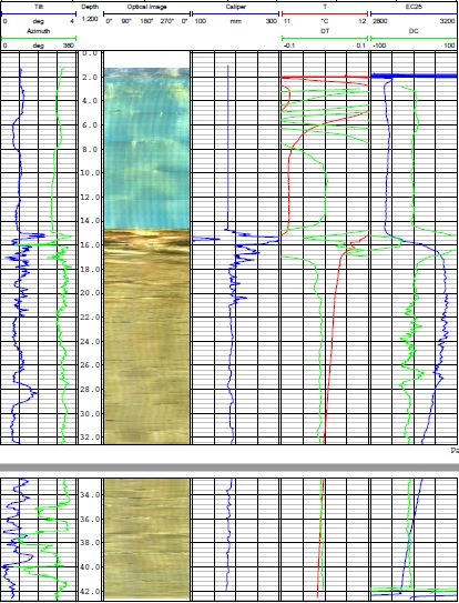
Downhole geophysics and fluid logs (
Figures, below) were taken at the new and accessible existing boreholes in the network. Fluid conductivity profiles provided an indication of salinity with depth at each location, and of vertical flow in boreholes. The suite of logs provided a good indication of inflow depths, which can be useful for future investigation and targeted sampling.
.JPG?h=561&w=413&la=en)
Interestingly, despite being some distance from the estuary, groundwater levels in the new monitoring boreholes demonstrate tidal variation, thought to be a pressure response. However, the results to date show there is no clear relationship between distance from the estuary and the amplitude of tidal variation as measured in the Chalk aquifer - suggesting that hydraulic connections are complex.
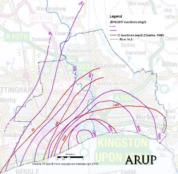
Results - Isochlor maps
The first set of water samples from the new monitoring network were taken in December 2016 and Chalk aquifer chloride results were plotted on an interpretive isochlor map. When compared with 1986 results (
Maps, below), results appear to show stabilisation of salinity in the southern central area of Hull.
The first noticeable difference in isochlors shows the apparent inland migration of saline water to the east of the River Hull. However, taking a closer look at historic plots one can see that actually no samples were taken in this area, and the interpretation may have been incorrect. The second difference is the apparent inland migration of the 50mg/l isochlor to the north-west of Hull towards the PWS abstraction sites.
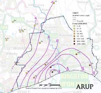
This is more interesting. With a general decrease in abstraction rates in Hull, and no known lowering of groundwater levels, why would there be further intrusion, when things appeared to have stabilised in the 1980s? Taken with the apparent lack of increasing salinity in central Hull, the results might suggest that the abstraction sites are causing the migration of brackish water that was already intruded from the Humber Estuary in the last century.
Maps - Isochlors map of Hull 2016 (top) and 2017-1986 comparison (bottom)
It is still early days for the investigation, and our focus now will be on building and analysing a robust continuous monitoring dataset, using traditional sampling methods along with conductivity and level loggers. Having an established network will also enable additional testing, such as dating of water - so there is plenty of scope for future research. Other sources of salinity (such as road salt-spreading, agricultural and other catchment influences) will need to be explored before jumping to any conclusions about the implications for the PWS. There is a however a clear case for the EA to maintain current restrictions on abstraction licensing in Hull.
Further research and understanding of the superficial cover, and influences of engineering at the coastal boundary and within the Humber Estuary, would benefit the study. Tools such as the British Geological Survey (BGS) Holderness geological model (
Geoscientist, July 2016), could provide a good starting point for refinements, developing understanding of potential hydraulic pathways in the Chalk, and helping to solve this age-old problem.
Protecting a resource
Despite many outsta
nding questions, these new data provide the first update in the published records since the late 1980s. The newly established aquifer monitoring network can now be used to provide regular sample sets, taken under controlled conditions using consistent methodology. This is a big step forward. Review of future results, and further research into wider catchment influences, will provide a sound scientific basis on which to make management decisions regarding sustainable abstraction.
Collaboration between Yorkshire Water and the EA, along with Arup and Leeds University, has been one of the key successes of this study. Pooling knowledge and experience, and working with local companies and Hull City Council to protect the existing monitoring network, has been - and will continue to be - essential for future scientific gains.
In a city that has such a celebrated bond with water, groundwater perhaps doesn’t get the recognition it deserves. The outcomes of the ongoing investigation will ensure long-term protection of a valuable resource.
Author
* Ellen Spencer is a Hydrogeologist with Arup, Leeds. E:
[email protected]
Acknowledgements
The author wishes to thank: Mark Morton, Paul Speight (Yorkshire Water), Hannah Threadgould (Environment Agency), Gerd Cachandt (Arup), Jared West, Simon Bottrell (Leeds University).
Further Reading
-
Chadha, D S (1986) Saline intrusion in the Chalk Aquifer of North Humberside, UK. Yorkshire Water Authority.
- Elliot, T, Chadha, D S, and Younger, P L (2001) Water quality impacts and palaeohydrogeology in the Yorkshire Chalk aquifer, UK. Quarterly Journal of Engineering Geology and Hydrogeology, 34, 385-398.
- Foster, S S D, Parry, E L and Chilton, P J (1976) Groundwater resource development and saline intrusion in the Chalk aquifer of North Humberside. British Geological Survey Research Report, 76/4.
- Gale, I N and Rutter, H K (2006) The Chalk Aquifer of Yorkshire. BGS Research Report RR/06/04
- Smedley, P L, Neumann I and Farrell, R (2004) Baseline Report Series 10: The Chalk aquifer of Yorkshire and North Humberside British Geological Survey Commissioned Report No. CR/04/128