Desmond Donovan tackles the mystery surrounding the true original course of the River Tyburn, and the identity and location of the fabled ‘Thorney Island’.
Introduction
Guide books and popular works2 tell us that the river divided into two branches at Buckingham Palace, the King’s Scholars’ Pond Sewer already noted, and a stream heading towards Westminster Abbey joining the Thames somewhere south of the Houses of Parliament. Some writers admit that there is some doubt about this second branch, though most explain that before reaching the Thames it divided into two branches which isolated Thorney Island, the legendary site of Westminster Abbey3.
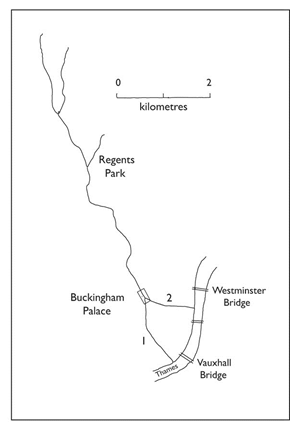
Fig. 1. Sketch map of the River Tyburn. Modified from Nunn, 1983. 1, King’s Scholars’ Pond Sewer or Vauxhall branch. 2, Westminster branch.
The southern or King’s Scholars’ Pond Sewer branch is well established, in the Middle Ages it formed the boundary between the manors of Wesminster and Eye4 which became the boundary between the parishes of St Margaret, Westminster, and - - -, Chelsea (??). This parish boundary was shown on the earliest Ordnance Survey large scale maps 1890s, now online as ‘historic’ maps) and indeed bisects the enclave of Buckingham Palace wherein boundary stones survived at least until the Ordnance Survey. South of the Palace it has an irregular course consistent with its origin as a stream, ignoring modern property boundaries until it reaches Tachbrook Street, formed by covering over the watercourse in 1842-445.
The eastern or Westminster branch, on the contrary, is described in the recent Victoria County History volume on Westminster as ‘an unsubstantiated watercourse from the abbey to the Tyburn’6. The main purpose of this contribution is to discuss this second branch and its supposed relationship to Thorney Island.
J. G. Waller and the Westminster branch
John Green Waller (1813-1905) was an artist and antiquary, a founder of the British Archaeological Association and of the London and Middlesex Archaeological Society. He was a Fellow of the Society of Antiquaries (source: Friends of Nunhead Cemetery website).
Waller, in his paper on the Westbourne and the Tyburn7, was much concerned with boundaries described in Anglo-Saxon charters. He interpreted a (forged?) charter of King Edgar, supposedly dated to 951, as referring to the Westminster branch of the Tyburn. Because the charter did not (in his view) refer to the King’s Scholars Pond Sewer branch, he concluded that the latter did not exist at that date8. He therefore regarded the Westminster branch as the original, natural course of the river Tyburn to the Thames. He described it following the course of James Street, then the west part of Caxton Street and Orchard Street, then joining Great College Street, along which it flows due east to the site of the Abbot’s Mill9 at the outfall to the Thames, south of the Victoria Tower of the Houses of Parliament. On the map in his paper, however, he showed both the southern and the Westminster branches (Fig. 2).
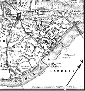 Fig. 2. Part of Waller’s map, 1890, enlarged. The River Tyburn and its supposed branches are shown by thick lines. A north point has been added.
Nunn in a research paper on the Flandrian evolution of the Thames10 concluded that the southern or Vauxhall Bridge Road branch was the original course of the river, but that it became silted up, being on the inside of a developing meander of the Thames, whereupon the river ‘cut the Westminster outlet’.
Westminster waterways
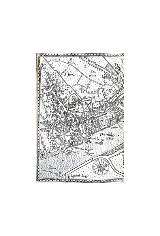
Early maps of Westminster show an outfall to the Thames south of Westminster Abbey, the first being in 157211. North of the outfall is a building labelled ‘The slaught/er howse’, south is a building which may be the mill. John Norden’s map of Westminster, 1593, has the annotation ‘The Q[ueen]s slaugh/ter howse / The myll’ (Fig. 3). This [Abbot’s] mill was rebuilt and enlarged in 1502/312 so this channel was older than that date. It lay south of the boundary wall of the Abbey precinct. This was ‘The Dead Wall’ of Ogilby and Morgan’s map of 1682, part reproduced by Tatton-Brown13, which shows the watercourse (crossed by bridges). The first (1870s) edition of the Ordnance Survey large scale plan records ‘Site of the Long Ditch’ here. The same plan marks ‘Site of the Abbot’s Mill’ at TQ 3025 7930. It lay north of No. 1 Millbank, the Ecclesiastical Commissioners’ building.
I have given some detail about this watercourse because it may, in fact, be the only evidence for the existence of the ‘Westminster branch’ of the Tyburn.
The ‘Long Ditch’ is only known for a length of 250 m or so. Where did the water come from? A spring is unlikely in the alluvial plain of the Thames. Tatton-Brown14 has proposed an explanation of the elusive Westminster branch. He supposes a man-made channel bringing water from the Tyburn to Westminster Abbey.
The Westminster monastery in its very obscure earlier history was small. It was rebuilt on a much larger scale by Edward the Confessor in the mid-11th Century. Building continued after the Confessor’s death in 1065, including the dorter, c. 1066-1075, and the reredorter ‘late 11th Century’15. The channel from the Tyburn may have been made in the first place to ‘flush out the monks’ reredorter’16 (and presumably the nearby kitchen and infirmary) in the 1080s. The length of the whole ‘branch’ would be about 1.25 km. Tatton-Brown17 discusses the water supply of the monastery in some detail and his interpretation is in line with the situation in other large monasteries.
It is unusual for a small river such as the Tyburn to divide into two branches near its mouth. There is no question of a delta. An artificial channel is a likely explanation, the more so because the supposed further bifurcation of the ‘Westminster branch’ to form Thorney Island was due to a misinterpretation by Waller, as will now be explained.
Fig. 3. (below) The southern part of John Norden’s map of Westminster, 1593. Watercourses are distinguished from streets by a thin wavy line or lines between the bounding lines. This does not apply to the southern outfall at The Myll, which has a bridge, and the ones flanking Myll banke. The zig-zag feature between the two sets of ditches north of Tootehyll streete has a different pattern which may indicate a track or footpath. Westminster Abbey with its prominent apsidal east end is seen below Sanctuary. Henry VII’s Chapel is not shown, but St Margaret’s church with its western tower is seen to the right of the Abbey. Lambeth howse on the opposite side of the Thames is Lambeth Palace. Scan courtesy of Philip Burden.
J G Waller and Thorney Island
Waller18 described the Westminster branch of the Tyburn, for him the original route of the river to the Thames, as detailed above. He then turned to the 1593 map of Westminster by John Norden. This large scale map (Fig. 3) appears to be a remarkably accurate record of the streets and built-up areas from Tootehyll streete [i.e. Tothill Street] in the southwest, past Charing Cross to the Strand, Covent Garden and Drury Lane. Buildings are shown in perspective and it does not have a scale, but it does have a north point, showing that the map is drawn with approximately west-north-west at the top.
The map does not show the King’s Scholars’ Pond Sewer section of the Tyburn, joining the Thames at Vauxhall, because it does not extend so far south. In St James’s Park, it shows a stream issuing from a pond [Rosamund’s pond] and flowing north-east. Several ditches connect with the stream. They are straight with right-angled bends, showing that they were artificial. Nearby to the east a second set of ditches are at least largely artificial. These ditches (Fig. 4 A) lie north of Tootehyll streete and of the Abbey and the adjoining Sanctuary. They were probably drainage ditches for the Abbey’s fields before St James’s Park was created in 1530 by Henry VIII. They were destroyed by later changes and landscaping19.
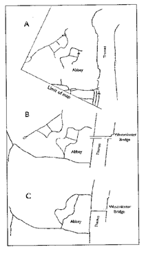
Fig. 4. Successive interpretations of the streams of the Westminster area: A. Stream and ditches from Norden’s map, 1593. B. The Westminster branch of the Tyburn and its branches as shown in Waller’ map, 1890. C. The same as shown in the Geological Survey Six-Inch map of 1920.
Waller misinterpreted the more easterly set of ditches on Norden’s map as a branch of the Tyburn, and assumed a connection with the channel which has its outfall at the mill (Fig. 4B), although Norden does not show one. Such a link, Waller supposed, had been ‘doubtless arched over for the convenience of dwellings’20. He further wrote that ‘we know that it [the assumed Tyburn branch] had an exit into the river a short distance west of Privy Stairs’ this was in fact the Clowson stream, another artificial waterway made for drainage21. On the map which accompanied his 1890 paper this outfall is north of Westminster Bridge at about TQ 3035 7990 (Fig. 2).
From these artificial channels Waller concluded that … ‘Thus we have the Abbey site isolated by a watercourse, which, divided into two, might … be called the double brook or Teo-burn …’22. He further identified the area thus isolated, the site of Westminster Abbey, as Thorney Island, probably from Widmore or a later source (see below).
The Geological Survey Six-inch map
Fig. 5. Part of the Geological Survey map of London at six inches to one mile, sheet v SW, 1920, issue of 1936. St James’s Park lake at top. The pink areas are Upper Floodplain Terrace, the remainder Alluvium. The River Thames to the right. Waterways in blue, including the supposed branches of the Tyburn between the two areas of Upper Floodplain Terrace.
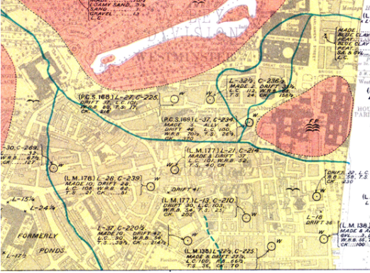
In 1878 Edward Stanford published the first large scale geological map of London, on the scale of six inches to one mile. Central Westminster is underlain by ‘alluvial deposits’, while ‘gravel & sand’ (i.e. Thames terrace gravels, mainly) outcrop to the north and west, and across the Thames in Southwark. The Geological Survey of England and Wales (now the British Geological Survey or BGS) began mapping the London district on the six-inch scale in 1910 and published its own map in 1920.
The local ‘gravel and sand’ was now identified as the Upper Floodplain Terrace of the Thames, and an isolated outcrop in the area of Westminster Abbey and the Houses of Parliament was shown (Six-Inch sheet London V SW) (Fig. 5) and on the One-Inch New Series sheet 270, 1921. The ‘lost’ rivers were also marked on the Six-Inch maps.
In the case of the Tyburn, both the southern and the Westminster branches were shown, and unfortunately also the branches that Waller had invented on the basis of Norden’s streams and ditches (Fig. 4 C; Fig. 5). They occupied a tract of alluvium about 270 m wide between the main gravel outcrop in St James’s Park and the Westminster gravel patch. This arrangement has served authors as the ‘bifurcating’ mouth of the Tyburn ever since.
Thorney Island
The area originally described by the name is unknown. John Flete, an early historian of Westminster Abbey, cites eleventh Century documents in the Abbey library which name Thorney as the place where Westminster Abbey was founded23. J. Armitage Robinson, paraphrasing Flete, wrote:
The Thames with its tides surrounds Thorney Island, two miles from the city. Here this wealthy Christian erected a church, and asked Mellitus to come and consecrate it. [Christians were summoned to the area] Tents were fixed half a mile from the church, for an inundation of the river prevented nearer access the night before. … St Peter appeared on the bank of the Thames, and called to a fisherman to take him across. [The fisherman was rewarded with an enormous catch].
Flete’s Latin text, which Robinson describes as ‘clumsy and long-winded’ in fact mentions Thorney island in four separate places. Flete’s sources were describing a miraculous event, the appearance of St Peter himself to consecrate the new church. The story does not necessarily refer to a particular place.
John Flete’s 15th Century account was not printed until 190923, but the Thorney Island story was published in English by Richard Widmore, the Abbey Librarian, in 1743 and 175124. It was probably due to Waller’s paper of 1890 that the location of Thorney Island entered popular guide books, such as Bell’s guide to Westminster Abbey (1902), and also more scholarly works. P. D. Nunn7 identified Thorney Island as the whole area between the southern and Westminster branches of the Tyburn, but he has not generally been followed.
Modern authors have regarded the isolated gravel outcrop, on which the Abbey and the Houses of Parliament stand, as representing Thorney Island, e.g. a ‘sand and gravel island … formed by the bifurcation of the River Tyburn where it met the Thames’25. Whether or not the watercourse from Buckingham Palace to Westminster is accepted as artificial, the ‘bifurcation’ of Waller can no longer be accepted. The streams north of the gravel outcrop, e.g. on the Geological Survey Six-Inch map (Fig. 5), are a fabrication.
Thomas26 published a computer-generated contour plan based on data from ‘modern excavation, antiquarian observations and boreholes.’ This was said to show the topography of the gravel surface at c. 10 000 BC. Sea level of course was then much lower than now, the River Thames flowed in a now-buried channel somewhere away to the south, and the gravel was being dissected. The gravel surface of the ‘island’ in Thomas’s map has a relief of about five metres. However, by Anglo-Saxon time this had been buried by late Quaternary deposits27.
Conclusion
The Westminster branch of the River Tyburn is an artificial channel. The formation of Thorney Island between two channels of the Tyburn derives from a misinterpretation of early maps and is no longer valid. The extent of the medieval Thorney Island remains uncertain. It appears to have been an island in the tidal Thames.
Acknowledgements
I thank Tim Tatton-Brown for numerous discussions and information. Philip Burden gave me information on mapmaker John Norden and electronic files of his maps of Middlesex and Westminster.
References
- Barton, N, 1992. The lost rivers of London. Revised ed. (place, publisher) Map 1, p. 14
- For example Barton, N. 1992 See note 1. Trench, R. & Hillman, E., 1985, London under London, London, John Murray; Talling, P., 2011, London’s lost rivers, London, Random House books.
- The question is summarised by Tatton-Brown, in press, 2015? The medieval and early Tudor topography of Westminster, Transactions of the British Archaeological Association Conference, 2013?).
- See Tatton-Brown, T. 2014, Westminster topography, London Archaeologist 14, 45-48; Croot, P. E. C., et al. (editors) 2009, Victoria County History of Middlesex, 13(1), 2.
- Bradley, S. & Pevsner, N. 2003. The Buildings of England. London 5: Westminster. New Haven & London: Yale University Press, p. 772.
- VCH Middlesex, see Note 4.
- P. G. Waller, 1890, The Tybourne and the Westbourne. Transactions of the London and Middlesex Archaeological Society 6, 244-279.
- Waller, 1890, p. 258-263.
- Waller 1890 p. 258. Tatton-Brown, in press.
- Nunn, P. D. 1983. The development of the River Thames in central London during the Flandrian. Transactions of the Institute of British Geographers 8(2), 187-213
- Braun, G. & Hogenberg, F. 1572. In Civitates Orbis Terrarum. Barker, F. & Jackson, P. 1990. The history of London in maps. London, Barrie & Jenkins Ltd, p. 13, believe that this map was based on a survey of about 1550.
- Tatton-Brown, T. 2014, Westminster topography, London Archaeologist 14, 48.
- Tatton-Brown 2014, Fig. 3.
- Tatton-Brown 2014, p. 48 and Fig. 2.
- Bradley, S. & Pevsner, N. 2003. The Buildings of England. London 5: Westminster. New Haven & London: Yale University Press, p. 193, 199.
- Tatton-Brown 2014, 48.
- Tatton-Brown, The medieval and early Tudor topography of Westminster, in prep.
- Waller 1890, p. 258.
- T. Tatton-Brown, personal communication.
- Waller 1890, p. 264.
- Tatton-Brown 2014, Fig. 2; Thurley, S. 1999. Whitehall Palace. New Haven & London, Yale University Press, pp. 41, 43, 57, 60.
- Waller 1890, p. 264.
- John Flete, The history of Westminster Abbey, edited by J. Armitage Robinson. Cambridge University Press, 1909. See also Harvey, B. 1979. Westminster Abbey and its estates in the Middle Ages. Oxford University Press, p. 20.
- Richard Widmore, An enquiry into the time of the first foundation of Westminster-Abbey, 1743; An history of the Church of St. Peter, Westminster, 1751.
- Sloane, B., Swain, H & Thomas, C. 1995. The Roman road and the river regime. London Archaeologist 7(14), 359-370.
- In Sloane, Swain & Thomas 1995, Fig. 2.
- D. T. Donovan, The Quaternary geology of Westminster, in preparation.
Save