Steve Mathers* on the 3D digital geological models that are now increasingly replacing printed maps as prime survey output.
Over the last decade many Geological Survey Organisations worldwide have begun to communicate their geological understanding of the subsurface through 3D geological models, and the traditional printed geological map has been increasingly phased out. This shift of emphasis has been made possible by modern computers, geological modelling software and delivery tools. The role of the geologist has however remained essentially the same, to gather all the relevant evidence (maps, boreholes, geophysics etc) and to come up with an interpretation of the geology.
Today BGS uses a range of modelling techniques varying from interpretative, deterministic to stochastic, depending on the geological situation and how much data is available. The main modelling software includes GSI3D (Quaternary and Anthropocene geology), GOCAD-SKUA (bedrock geology) with Petrel mainly used for flow modelling and also 2DMove for section restoration and fault dynamics.
Clients for models are many and varied and have included the Environment Agency (EA), Nuclear Decommissioning Authority (NDA), the Department for Energy and Climate Change (DECC), together with the Water, Utility, Transport and Engineering sectors. Models have also been built for educational and research purposes.
Two recently released outputs are the GB3D onshore bedrock model and the London and Thames Valley model
GB3D bedrock model
Over the last five years as part of its National Geological Model programme and also with funding from the EA and NDA, BGS has constructed a national resolution fence diagram model of the onshore bedrock geology of Great Britain (Figure 1).
The model covers England, Scotland (except the Shetland Isles) Wales and the Isle of Man and was built with contributions from 17 regional specialists supported by a team of data managers and developers. The model broadly adopts the colour schema and geological classification of the BGS 1: 625 000 scale bedrock geology maps with some simplification, faults are indicated by offsets in the geology. Constructed using the GSI3D software, the sections are tied to over 300 important deep boreholes. The model also takes account of existing BGS onshore models of bedrock geology which are themselves underpinned by BGS’s vast collections of boreholes, seismic lines and regional geophysical data. The cross-sections extend to depths up to 5 km, with a minimum depth of 1.5 km, together they comprise over 25,000 line kilometres of section. A similar model but at a deeper crustal scale covering parts of Ireland, Northern Ireland and Scotland was highlighted in the Geoscientist last year by Graham Leslie and colleagues.
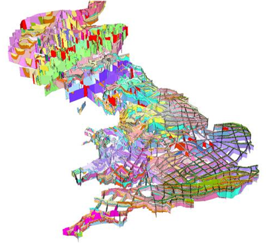
Figure 1. The GB3D bedrock fence diagram model
The model has been used to map the subsurface extent and produce first order volumes for major aquifers, sources of unconventional hydrocarbons, and to communicate the geology of Great Britain to geoscience students, researchers and the general public, an extract of the model has also been used in the new BGS regional guide for East Anglia scheduled for release later this year.
The model was recently demonstrated at the Geological Society as part of the Communicating Contested Geoscience meeting on June 20th. The latest version of the model is available for free download at http://www.bgs.ac.uk/research/ukgeology/nationalGeologicalModel/GB3D.html.
Formats include 3D PDF, KMZ (for Google Earth), BGS Viewer, and exports of the bases of stratigraphic units down to the Pridoli (topmost Silurian) in grid and proprietary software formats such as GOCAD and Petrel.
The construction of the 2012 version of the model is described in GB3D – a framework for the bedrock geology of Great Britain - Mathers - 2014 - Geoscience Data Journal - Wiley Online Library
London and Thames Valley model
The London and Thames Valley model (Figure 2) is a full 3D volume model of the Anthropocene, superficial and bedrock geology down to a depth of a few hundred metres. The model is a subsurface extension of the 1: 50 000 scale digital geological map. It was built using a combination of GSI3D and GOCAD and covers 4800 square kilometres along the London Basin encompassing an area 40 km in breadth stretching from Thatcham and Didcot in the west to Basildon and Tilbury in the east. Similar models also exist for parts of southern East Anglia covering Ipswich, Sudbury, Colchester and Chelmsford. The model takes into account several thousand boreholes including most of those that exceed 100m in depth. It is suitable for use at a regional-district scale and can also act as a framework within which more detailed site or linear route models can be constructed. Examples include models built for the new Crossrail Farringdon tube station and along the proposed HS2 route from Euston northwestwards.
Anthropocene deposits and Head are depicted in the model as 2D coverages draping the surface as modelling the 3D form of these discontinuous deposits is very labour intensive. In London far more artificial ground is known to be present than can be depicted in this model.
BGS will give a preview of the model during a buffet lunch and afternoon meeting entitled ‘The Geology under London and the Thames Valley’ at Burlington House on the 17th October 2014, from noon. Admission is free to Geol Soc members, BGS staff and invited guests but registration is required as space is limited. Please register for this event at https://www.surveymonkey.com/s/GeologyUnderLondon. The programme of talks will introduce the model and experts from industry and academia will reflect on their experience of using the model in practice. The BGS geologists responsible for building the model will be in attendance to demonstrate the model and discuss its various applications.
BGS encourages the use of its data for teaching and research. BGS will wherever possible make the London and Thames Valley model available without charge. The only exception will be where additional steps are required to transform or reformat our data.
For commercial use the model will be available via a range of new products. Synthetic boreholes, cross sections and horizontal slices will be available via the web and will be presented in a format that can be directly incorporated into reports. Geological unit surfaces and grids from the model will also be available as licensed data and can also be provided in interactive formats using bespoke software.
- For more details of BGS models and modelling capability please contact Steve Mathers [email protected]. Please contact [email protected] for information about data availability, licensing costs and delivery options.
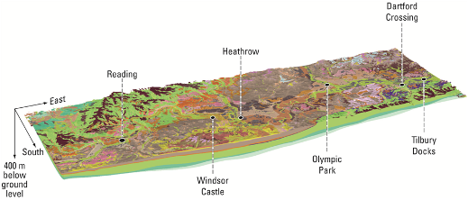 Figure 2. The London and Thames Valley model viewed from the southwest, the pale green is the Chalk Group, mid-brown is London Clay, this view extends to the base of the Cretaceous strata.