Peter Jones and Vanessa Banks* on the research potential of the geology uncovered by the construction of a wind farm.
 The construction of wind farms is on the rise. According to the UK Wind Energy Database (UKWED) 1, 4366 onshore wind turbines are currently operating at 584 sites in the UK, with a total onshore capacity of 7172 MW. In addition, 722 turbines (79 onshore) are under construction, and a further 2305 (814 onshore) where construction approval has already been granted.
The growing development of onshore wind farms is often controversial, particularly in relation to concerns over their environmental impact. This is a matter for the planning approval process; but where approval is granted, construction can have some significant but unintentional geological benefits.
As noted by Chris King (Geoscientist 22.4, May 2012, p.23) temporary exposures arising from the excavation of footings for wind turbines may provide valuable opportunities to assess and record new data. This was certainly our experience with the construction of Derbyshire’s first commercial wind farm at Carsington Pasture, three kilometres west of Wirksworth. The temporary exposures on this site revealed a range of interesting and potentially important geological features.
Carsington Wind Farm
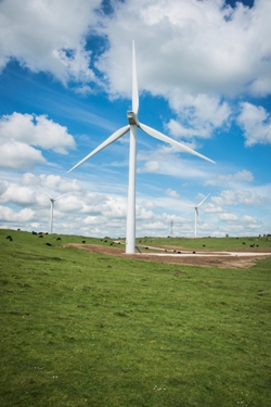
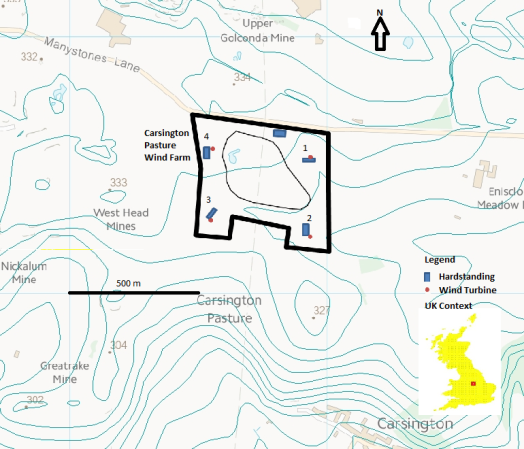
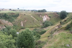
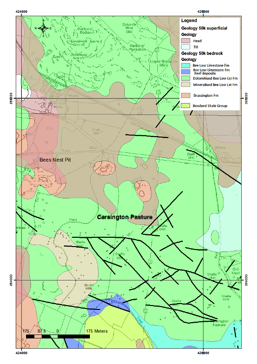 Carsington Pasture (picture, above, generalised geology left, site layout below right with numbered turbine locations) is a broad tract of limestone grassland on a moderately undulating upland plateau at around 300m OD. It is bounded to the northwest by the prominent outcrop of Harboro’ Rocks rising to 379m OD, while immediately to the south, the plateau edge forms a steep slope towards Carsington village. Archaeological evidence indicates that the local landscape has undergone a long history of human activity extending back to prehistoric times.2 The wind farm was constructed on the plateau surface and involved erecting four Repower MM82 turbines together with access tracks, and an ancillary substation. Each three-blade turbine has a hub height of 59m and a blade length of 41m giving a total height of 100m. With a combined output of 8.2MW, the wind farm will generate sufficient electricity annually to power the equivalent of at least 4500 homes.
A planning application for the wind farm was submitted in January 2007 by Carsington Wind Energy Ltd., a subsidiary of West Coast Energy Ltd. Located on elevated ground just outside the southern boundary of the Peak District National Park and overlooking the popular visitor attraction of Carsington Water, the project provoked opposition from the outset.
Environmental concerns contributed to a lengthy planning process, involving a public inquiry followed by an appeal hearing in the High Court, delaying the project by several years. Following planning approval, construction work at Carsington Pasture started in May 2012 and was expected to take approximately six months. However, the work was subject to further delay due to unforeseen and problematical ground conditions. The turbines eventually became operational in March 2014.
Geological context
The geology of the site comprises Lower Carboniferous limestones with a variable cover of natural and anthropogenic superficial deposits. Included in the latter category is widespread spoil resulting from a long history of mining activity, primarily for lead and zinc ores. Additional spoil was produced during the more localised extraction of silica sand and clay from dissolution pockets in the limestone, for use mainly in the manufacture of refractory bricks. Most of the pits have been backfilled and relatively few sections remain.
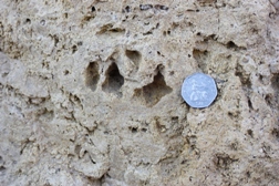
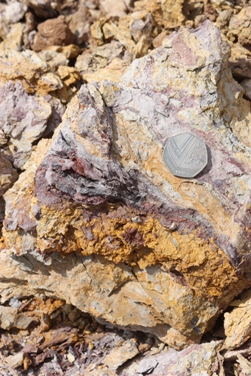
 Picture: Inclined clay wayboard in dolomitised limestone at T4 with Harboro’ Rocks in the distance to the NW .
The natural superficial deposits include Quaternary head deposits, tills and localised accumulations of fluvioglacial gravels.The limestones belong to the Bee Low Limestone Formation (Asbian) and were deposited on the southern margin of the Derbyshire Carbonate Platform adjacent to the subsiding Widmerpool Gulf. Interbedded with these rocks are layers of weathered volcanic ash (clay wayboards). The edge of the platform is characterised by a series of Waulsortian mud mounds (apron-reefs) composed mainly of fine-grained micrite. In the deeper water off-shelf province farther south, the sediments of the Widmerpool Formation comprise a thick sequence of mudstones and dark thinly-bedded turbiditic limestones.
Picture: Downwarp of clay wayboard into sediment filled fissure in T4.
At Carsington Pasture, the Bee Low Limestone has been fractured, dolomitised, mineralised and subjected to deep karstification. The onset of compressional tectonics associated with the Variscan orogeny resulted in multiple phases of fault/fracture controlled movement of mineralising fluids. The geological setting of the mineral deposits in this area has been described by Ford (2007)3 and conforms to a ‘Mississippi Valley’ type model. An extensive distribution of capped shafts and spoil heaps demonstate that the ground has been extensively worked for minerals, mainly cerussite and galena as sources of lead.
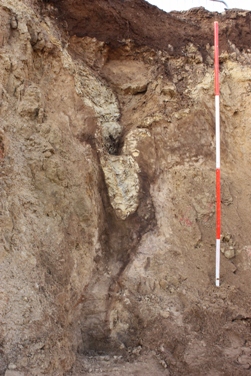
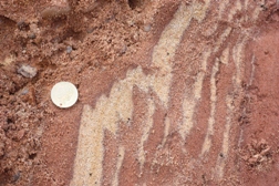
A significant result of karstification was the formation of dissolution hollows and widened fissures that have been infilled by a variety of unlithified sediments. These scattered features are traditionally referred to as “pocket deposits”. The sediments predominantly comprise gravels, sands and clays, which are often deformed by subsidence or collapse into the solution cavities. More than sixty pockets are known from the southern part of the limestone outcrop of the Peak District and the sediments are thought to be the remnants of a former continuous cover.4 They constitute the Brassington Formation, which has been ascribed a Late Miocene age on the basis of pollen.5 The type locality at Bees Nest Pit is located approximately 450m west of the wind farm site. Previous workers have suggested that the Brassington Formation was deposited in a fluvial environment close to sea level and this view has implications for interpreting the post-Neogene evolution of the area’s current upland landscape.
Temporary exposures
 Picture: Vuggy dolomite in T4.
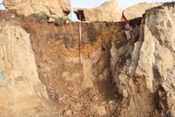
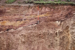
Foundation work for the turbines involved excavating roughly circular pits up to 16m in diameter and 3m deep. These temporary exposures were subsequently deepened and widened to allow for more substantial foundations as the extent of intensively fractured rock, sediment filled fissures and deep pockets of unlithified sediment became apparent. The difficult ground conditions also necessitated additional site investigation work, involving drilling, trial pitting, trenching and geophysical surveys prior to emplacement of the foundations. From a geoscience perspective, this happy hiatus of several months (between the initial breaking of ground and the eventual construction phase) provided valuable research opportunities. While appropriate foundation solutions were being considered, it was possible to undertake detailed logging and recording of the geology of the site. Temporary sections in the dolomitised limestone showed that jointing is extensively developed, although frequent variations in joint spacing and continuity were apparent.
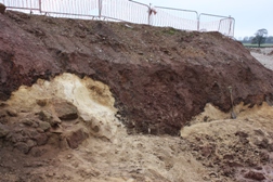
 Picture: Deep pocket deposits in Bees Nest Pit.
Unsurprisingly, the dominant joint-sets were closely aligned with known mineral veins. Various closely spaced fractures and curvilinear joints require further interpretation but may be related to phases of hydrofracturing. Commonly, the rock forming the joint walls and zones of closely spaced fractures had been locally altered to dolomite sand, suggesting the preferential leaching of a former calcite cement. Upon exposure, this loose granular material was readily removed by wind or rain and clearly would be equally susceptible to groundwater flow.
 Picture: Small U-shaped pocket in T1 with deformed sediments.
Karst features recorded in the temporary exposures were variable in morphology and scale. Particularly notable was a subdued form of pinnacle karst. This was usually associated with the zones of dolomite sand and tended to collapse upon exposure. Other karst features indicative of vadose-zone dissolution range from joint enlargement to more extensive doline forms up to tens of metres in diameter. The shallower dolines are commonly “U” shaped, while the deeper features are more irregular and their development appears to have been influenced by both bedding and jointing.
In all cases, the dissolutional cavities were filled by sediment. Evidence for deeper (> 15 m) karst features comes from the observation that loose sediment was lost into joints following periods of rain. In addition, caverns up to 30m high and containing in-washed sediment have been reported from the nearby Golconda mine at depths up to 48m or more below ground level.3
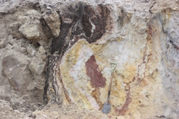
 Picture: Collapsed dolomite blocks and sand with wad-lined diamicton contact in T2.
Many of the karst features were lined with a relatively low density, brownish-grey to black deposit that is currently being subject to a suite of chemical analyses. Preliminary results indicate the material is wad (manganiferous soil). This has been reported previously in the vicinity of Carsington Pasture and in the past was worked for pigment. A notable feature of the deposit at this location is its continuity in lining many of the karst features and its highly sinuous form in both vertical and horizontal sections.
Sediments
 Picture: Vari-coloured clay in T1
The range of sediments and structural deformation exposed within the dolines was particularly interesting. The sediments included vari-coloured silty clays (red, brown, purple, green, yellow) interbedded with reddish brown and yellowish brown sands and gravel. The clasts were commonly rounded quartzites of small to large pebble and cobble grade. Locally, and particularly in the shallower features, the gravels comprised fractured cherts. Although the sediments display similar lithologies to those present at Bees Nest Pit, they represent a more varied assemblage both stratigraphically and structurally. This probably reflects a multi-phase history of emplacement. A brown, overconsolidated, matrix-dominated diamicton was revealed in several locations. It is likely to be equivalent to the till deposits mapped by the British Geological Survey (BGS) in pockets to the east of Carsington Pasture; but in some cases it may represent the product of debris flows. Extensive sediment fill was noted in some joints. This ranged from slightly clayey dolomite sand to sandy clay and creamy white clay wayboard that had been squeezed into the joints in locality T4. The range of structures revealed a complex interplay between the dissolution and the sediment fill, with sediment structures providing further evidence of the extent of deformation. Some of the joint fills may have been introduced by pressurised meltwaters during Quaternary glaciation.
 Picture: Layered sediment fill to wad-lined buried doline in T2.
As the excavations were extended, serial sections revealed the geology in 3D. At times this was particularly intriguing. For example, what appeared at first sight to be inclusions of wad in dolomite sand sometimes proved to be an irregular subvertical wall of an adjacent wad-lined pocket as the dolomite sand was cut back. Similarly, the detailed geometry of the sediment-filled pockets was typically much more complex than might have been predicted from initial evidence.
Research potential
Ongoing studies will help to elucidate the following aspects:
- Dolomitisation and fluid flow processes on the carbonate platform edge
- Karst hydrogeological evolution
- Provenance and age of the sediments in the pocket deposits
- Mode of sediment emplacement and subsequent history
- Denudation chronology of the southern Peak District, including rates of uplift.
Picture: Soft sediment deformation adjacent to fractured dolomite in T1.
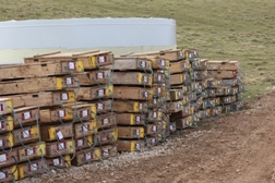
The site investigation at Carsington Pasture produced a large quantity of borehole core that was scheduled for disposal at the end of the construction contract. Negotiations via the site manager resulted in the developer agreeing to the bulk of the core being donated to BGS. Some 250 boxes of core have since been indexed and are now housed in the BGS Core Store at the National Geoscience Data Centre, Keyworth.
One project that will immediately benefit from this new resource is a CASE studentship based at the University of Manchester. An aim of the PhD research is to determine whether the reconstruction of (Carboniferous-Permian) palaeofluid flow paths in an intensely dolomitised carbonate platform margin can provide insight into the extent of hydrocarbon migration from clay-rich successions in adjacent hanging wall basins.
This will be achieved by investigating the interdependency between fracturing, dissolution and fluid flow (resulting in dolomitisation, silicification, hydrocarbon emplacement and lead-zinc mineralisation) at the platform edge. It will involve field and core-based sedimentological and structural analyses, petrological studies, isotope analyses, fluid inclusion studies and some fluid-flow modelling. The starting hypothesis is that the source of the fluids was initially deep seawater and basinal brines carrying hydrocarbons and Mississippi Valley type mineralising fluids derived from the subsiding Widmerpool Gulf.6
Conclusions
 Picture: Soft sediment deformation of quartz sand in T2.
The study has generated a wealth of geological information that will contribute to understanding the geological evolution of the carbonate platform edge. Moreover, detailed laboratory analysis of the borehole cores and other samples obtained from the site is continuing and promises to yield further useful geodata for some time to come. Our experience at Carsington Pasture supports the view expressed elsewhere in this magazine by Chris King that the current expansion in wind farm projects presents a valuable opportunity to acquire new data. A key point made by King is that the geoscience community would benefit from a more integrated approach in such circumstances to facilitate the retrieval of potentially useful non-geotechnical information.
This also underlines views expressed by John Powell et al., (Geoscientist 21.11, December 2011, p.7) of the value of capturing and archiving scientifically important information revealed by temporary exposures before it is lost to science. Some geologists would like to formalise such a process. For example, David Nowell (Geoscientist 24.4, May 2014, p.15) suggested that legislation is needed to facilitate access to temporary sections to ensure that relevant information is added to a national database
 Picture: Core boxes
At present, the investigation of temporary exposures requires the cooperation and goodwill of the client, the geotechnical consultants, the construction contractor and other operatives as well as compliance with the relevant health and safety procedures. Equally, it requires that the researcher engage in flexible working practices around the site operations. Our work at Carsington Pasture certainly benefited from such relationships. Additionally, we believe that on-site discussions with members of the project team were mutually beneficial.
Acknowledgements
The authors are grateful to Carsington Wind Energy Ltd and West Coast Energy Ltd (GDF Suez) for permission to investigate the temporary exposures at Carsington Pasture. We also wish to thank Roger Durrant (Raymond Brown Construction Ltd) for facilitating access to the site, Dr Jim Riding for reviewing this article and Matt Howcroft for the post-construction images of the wind farm.
References
- http://www.renewableuk.com/en/renewable-energy/wind-energy/uk-wind-energy-database/index.cfm (Accessed 4 May 2014).
- Willies, L. 1995. Roads, agricultural features and mines on Carsington Pasture. Bulletin of the Peak District Mines Historical Society 12, 19-23.
- Ford, T.D. and Jones, J.A. 2007. The geological setting of the mineral deposits at Brassington and Carsington, Derbyshire. Mining History 16(5), 1-23.
- Walsh, P.T., Boulter, M.C., Ijtaba, M. and Urbani, D.M. 1972. The preservation of the Neogene Brassington Formation of the southern Pennines and its bearing on the evolution of Upland Britain. J. Geol. Soc. London 128, 519-559.
- Pound, M.J., Riding, J. B., Donders, T.H. and Daskova, J. 2012. The palynostratigraphy of the Brassington Formation (Upper Miocene) of the southern Pennines, Central England. Palynology 36, 26-37.
- Hollis, C. and Walkden, G. 2002. Reconstructing fluid expulsion and migration north of the Variscan orogen, Northern England. Journal of Sedimentary Research, 72, 5, 700-710.
* Peter Jones is Emeritus Fellow in the School of Science, University of Derby. Vanessa Banks is Team Leader for Shallow Geohazards and Risks at the British Geological Survey.