Peter Clift* on the origin of the big rivers of Asia
 The highest and youngest continent on Earth, Asia, is also the home of many of the largest rivers on the planet. Although the Amazon has the greatest water discharge of any river on Earth, the great streams draining the Tibetan Plateau and Himalayan Mountains carry the largest sediment loads. These not only support human activities but also feed the biggest submarine sediment accumulations in the adjacent deep ocean basins of the Indian Ocean and the Western Pacific marginal seas. The submarine fans are of greater scientific and commercial interest; but every grain of sand deposited there had first to be transported by the rivers to the coast. Understanding how the rivers have evolved is essential if we are to decipher the deep sea stratigraphic record.
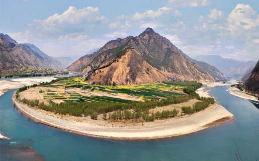
Above: Panoramic picture showing the first bend of the Yangtze River in Yunnan, Southwest China. In this location the Yangtze changes its direction of flow from towards the south back towards the northeast for the first time since starting its journey in Tibet.
Because rivers have to flow downhill, it has long been accepted that the development of topography in Asia following the collision between India and Eurasia around 50 million years ago (Ma) would have resulted in a significant reorganisation of the original river systems. In the Palaeogene Central Asia was covered by the shallow seas of the Paratethys, but southern Tibet and those regions now exposed along the southern coast of China were elevated areas, as a result of the deformation and magmatism of a subduction-related arc during the Mesozoic.
The Oligocene extension and deepening of the South China Sea, coupled with the growth of the Tibetan Plateau, resulted in a reversal of the original regional gradient. Likewise, in eastern China extension, starting in the Oligocene and culminating in the Miocene (probably linked to rollback of the Pacific plate) resulted a series of basins opening and subsidence accelerating in the East China Sea just as the Tibetan Plateau was growing towards the east and north. Together, these processes resulted in a re-tilting of the regional topography towards the Pacific Ocean.
HEADWATER CAPTURE
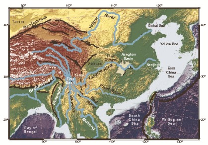
The region of Southwest China, northern Vietnam and southeastern Tibet is particularly noteworthy in understanding how the rivers have developed during the Cenozoic because it has several large rivers (Irrawaddy, Salween, Mekong, Red and Yangtze) that flow within about 180km of one another, separated by parallel mountain ranges. Early models, which suggested these streams are passive strain markers brought together by deformation of the upper crust, have mostly given way to hypotheses based on the idea that they represent fragmented parts of one larger pre-collisional river system that has been disrupted by topographic growth as it spread from NW to SE - a view championed by Marin Clark, now at the University of Michigan.
 The Red River (right) in particular attracted attention as being potentially the ancestral “mother river” of eastern Asia. In this scenario the modern river represents only the main stem of the palaeo-river, with the headwaters having been lost to adjacent major drainage basins; although more recently provenance work has suggested that this basin may not have involved quite as many neighbouring drainages as some of the original models were inclined to believe.
Data from the sedimentary basins formed along the India-Eurasia suture zones now suggest that many of the rivers began their life shortly after the collision between these major continental blocks. I and a number of colleagues, most notably Graham Layne now at Memorial University in Newfoundland, used Pb isotope measurements of single grains of potassium feldspar analysed by ion microprobe from the Indus Molasse of Indian Ladakh to show the start of an axial river draining west into the Arabian Sea shortly after around 50Ma. This was supported by later U-Pb dating of detrital zircon sand grains from the same sequences.
Likewise, new data based on U-Pb zircon dating of sandstones within the Central Burma Basin and analysed by Ruth Robinson and colleagues at St. Andrews University, show a convincing link between the Irrawaddy River and the Brahmaputra/Yarlung Tsangpo in Tibet, demonstrating that large rivers had started to drain the suture zone effectively after the time that sea water had been eliminated from within the collision zone. As soon as the colliding continents had started to generate topography, the new rivers began to exploit it; and these streams have probably been in place, draining through the western and eastern syntaxes, since that time.
COMPLICATED
The situation in eastern Asia is however more complicated because the major rivers from Tibet are flowing parallel to the structural grain out of the plateau and are also affected by the gradually expanding nature of Tibetan topography. It is now becoming apparent that the time around the Oligocene-Miocene transition, ~24Ma, is one of major change for the river systems. It may not be a coincidence that this was also a time when the Asian monsoon began to strengthen significantly in South and Southeast Asia, resulting in higher discharge and faster sediment delivery to the continental margins supplied by the major rivers.
In 2006 Nguyen Anh Duc from the Vietnam Petroleum Institute, Jerzy Blusztajn from the Woods Hole Oceanographic Institution and I, then working at the University of Aberdeen, proposed that the Red River had achieved much of its present geometry as a result of losing its drainage connection to what is now the central Yangtze drainage, most notably around the Sichuan Basin in SW China. This model was based on the bulk composition of sediment deposited under the modern delta of the Red River.
Nd isotopes were used to identify the bulk provenance of the river and showed the palaeo-river sediments achieving values comparable to the modern river before around 24Ma. Subsequently, application of Pb isotope methods to single grains of potassium feldspar and analysed in the ion microprobe at Edinburgh University allowed us to make a link between the Red River delta and the Yangtze Craton, exposed in central southern China - the loss of drainage occurring before 24Ma, at the start of the Miocene. The same study ruled out any connection between the Red River and the Brahmaputra, as well as with the Mekong or Salween. This limited the size of the palaeo-Red River. Subsequently, Long Van Hoang, now at the Hanoi University of Mining and Geology, used zircon dating of fluvial sedimentary rocks in northern Vietnam to support this general picture of a larger palaeo-Red River extending into central China before the middle Miocene, but not one covering the enormous areas first proposed.
GROWING TOPOGRAPHY
 Picture: MODIS satellite image of the Yangtze Delta in flood in 2003.
This general picture of drainage reorganisation seemed to be broadly consistent with new data on the uplift history of the plateau. Earlier attempts to look at how the elevation has changed focused on a rapid uplift starting about 8Ma, some workers even favouring rapid uplift extending as late as the Pleistocene (younger than 1.8Ma). Others, including Paul Tapponnier (Earth Observatory of Singapore), favoured a stepwise uplift, starting in the Eocene.
These models have now been tested thanks to the development of stable isotope proxies for plateau elevation and applied to lake deposits and calcretes within continental sediments. These argue that southern Tibet came close to its modern elevation either shortly after - or even before - the collision with India, and that topography grew from this nucleus. Thermochronology work led by Marin Clark in the gorges of eastern Tibet, showed that these valleys were primarily cut after around 11Ma; but that did not preclude an earlier uplift involving a gentle tilting towards the East, which would have been sufficient to reorganise the rivers into the new pattern we see today.
Thus we can envisage a progressive growth of topography, spreading from the collision zone, driving major drainage reorganisation across eastern Asia starting in the Oligocene.
ROLE OF THE YANGTZE
 Within this overall framework of evolving topography the Yangtze stood out as being anomalous because many geologists considered the river to be of Pleistocene age and certainly not more than a few million years old. This was despite its very central location between several other basins, its origins within the Tibetan Plateau and the fact that many models invoke headwater capture between the Yangtze and its neighbours.
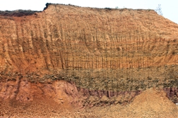
Picture: Outcrop of the Yangtze Gravels at Guizshan, near Nanjing in the lower reaches of the Yangtze River. Volcanic rocks interbedded within the sequence show that these river sediments were deposited before 23 Ma.
The supposed young age of the Yangtze was based mostly on the observation that large deltaic clinoforms in the region of the modern river mouth only date back as far as the Pleistocene; but this presumed that the river mouth had not moved, despite the widely recognised tendency of such systems to avulse (as has been well documented in the Mississippi).
Picture: Outcrop of the Yangtze Gravels at Hengshan, near Nanjing in the lower reaches of the Yangtze River. Volcanic rocks interbedded within the sequence show that these river sediments were deposited before 23 Ma.
 Furthermore, zircon data collected by Ping Kong and colleagues from the Chinese Academy of Sciences in Beijing from close to the ‘first bend’ (the apparent capture point between the Red and the Yangtze rivers) seem to suggest a re-routing of the river from south to the northeast after only 1.7Ma. Why would the Yangtze River be so young, when the topography of Eastern Asia appears to have been in continuous development through much of the Cenozoic? Where would the water from eastern Tibet have flowed without the Yangtze, prior to the Pleistocene?
This question was of particular interest to my colleague Hongbo Zheng, who living in Nanjing encounters the Yangtze on a daily basis. He observed a series of fluvial sedimentary rocks exposed close to the city that were covered by lava flows. These sequences are known as the Yangtze Gravels and have always been assumed to be of Pleistocene age. However, Zheng and his colleague Fred Jourdan (Curtin University) sampled the flows and using the Ar-Ar method dated them as older than 22Ma!
As a result they were able to conclude that these sediments could act as a monitor of how well formed the Yangtze was during the Early Miocene. A number of samples were then taken from the sediments beneath the lava flows, and the zircon sand grains dated at Nanjing University using the U-Pb method. At the same time, sediments were taken from the modern Yangtze River and analysed similarly. The range of ages was very wide but can be divided up into families reflecting the times of orogeny and crustal formation in eastern Asia.
Below: Pie diagrams showing the simplified age composition of zircon sand grains within Yangtze Gravel sediment taken from close to Nanjing compared to the modern Yangtze River at Nanjing, the modern Yellow River and a composite average of sands from the Yangtze Delta since 3.1 Ma. Taser from Zheng et al. (2013).
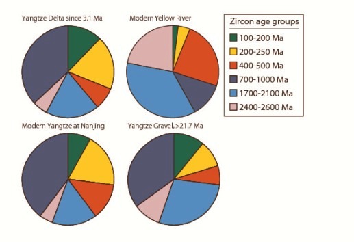 The illustration (left) shows the close similarity between the age populations in the Yangtze Gravels and those in the adjacent modern river. Although there is some variability, even in the modern system (because of seasonal floods, climate change and even anthropogenic disturbance) it is apparent that all the major age populations are present, and in approximately similar proportions, in both the gravels and the modern river. Zheng interpreted this to indicate the gravels were being deposited from a river that was essentially similar to the present-day Yangtze. When the same deposits were compared with other potential rivers, such as the Yellow River, a very poor match was found.
REORGANISATION
Understanding that the Yangtze River must be at least 22 million years old means that this river, consistent with data from the Red and Irrawaddy Rivers, indicates large-scale re-organisation at the start of the Miocene. The Yangtze appears to have taken up its present course immediately after it was captured from the Red River.
Where was this river flowing if there was no delta in the present location? Zheng has identified thick sequences of clastic sedimentary rocks within the Subei Basin, which lies just to the north of the modern river mouth and which seems to have been one of the primary depocentres for this earlier drainage system. If the river reaching Nanjing was really flowing close to the present course before 23Ma then this implies that the Yangtze must have been passing through the Three Gorges region by that time (below).
Below: Proposed development of the river systems in Eastern Asia and its relationship to the growing topography of the Tibetan plateau as well as the large-scale faulting that controls both the extrusion of Southeast Asia and the development of basins along the eastern margin of China during the Miocene.
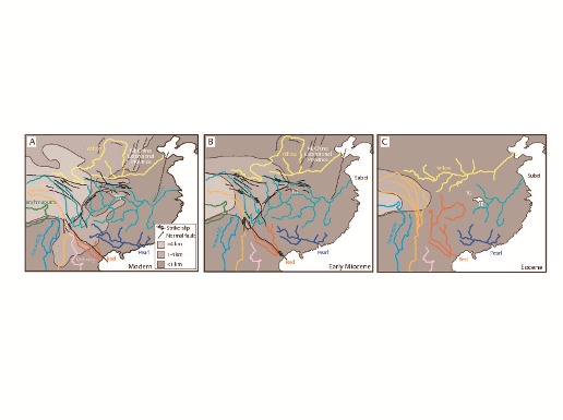
In order to do that it has to flow through the Jianghan basin, which lies immediately downstream of the gorges. During much of the Paleogene this basin was receiving mudstones and evaporite deposits, which continued until just before 36Ma. It is inconceivable that the lake in which the sediments formed (and which must have occupied the center of the Jianghan Basin) could have been supplied by the Yangtze River, because the volume of water would have been too great to have permitted the evaporites to have formed. This means that the Yangtze could not have flowed on its modern path until after 36Ma.
This new study places the Yangtze firmly within a coherent pattern of drainage development in Eastern Asia. It is a system in which major rivers are directly related to topographic uplift within the general region of the Tibetan Plateau, starting within the Paleogene. Gradual tilting of the continent towards the East forced the drainage systems to evolve.
A number of independent studies now show that the major rivers changed their provenance at around the same time, close to the start of the Miocene. That is not to say that small adjustments have not been made subsequently, not least because river systems tend to evolve through time - especially through headwater erosion leading to moderate degrees of drainage capture.
Nonetheless, the major adjustment we see close to the start of the Miocene reflects a critical time at which high topography was beginning to form in a climate where the monsoon was intensifying and also when extensional basins were opening along the southern and eastern edges of the Asian mainland. There are close two-way inter-relationships between climate, tectonics and erosion in Cenozoic Asia, with the rivers often acting as the mechanism that allows the feedbacks to take place.
The antiquity of the Yangtze is now well placed within our improved understanding of how Asia has deformed and grew since collision with India.
* Peter Clift is Charles T McCord Jr Professor of Petroleum Geology in the Dept of Geology and Geophysics, Louisiana State University, Baton Rouge E: [email protected].
Further reading
CLARK, M.K., SCHOENBOHM, L.M., ROYDEN, L.H., WHIPPLE, K.X., BURCHFIEL, B.C., ZHANG, X., TANG, W., WANG, E. AND CHEN, L., 2004. Surface uplift, tectonics, and erosion of eastern Tibet from large-scale drainage patterns. Tectonics, 23, TC1006, doi:10.1029/2002TC001402.
CLIFT, P.D., BLUSZTAJN, J. AND NGUYEN, D.A., 2006. Large-scale drainage capture and surface uplift in eastern Tibet-SW China before 24 Ma inferred from sediments of the Hanoi Basin, Vietnam. Geophysical Research Letters, 33(L19403), doi:10.1029/2006GL027772.
ZHENG, H., CLIFT, P.D., TADA, R., JIA, J.T., HE, M.Y. AND WANG, P. 2013. A Pre-Miocene Birth to the Yangtze River. Proceedings of the National Academy of Sciences, doi:10.1073/pnas.1216241110.