Michael de Freitas1 and Katherine Royse2 say geologists and engineers from all backgrounds can now contribute to revealing the nature of the ground beneath London, its geological history, and predicting ground conditions within the Basin.
Geoscientist 19.10 October 2009
Everyone associates London with the upper crust, and probably no part of it is better investigated, anywhere in the world, than under our capital city. Countless vertical boreholes have been drilled for ground investigation, aggregate evaluation and water supply, kilometres of horizontal tunnels excavated for railways, cable tunnels, water tunnels and sewers. You might think that the geology of London is, therefore, well known - but not so!
London has a history of "anomalous ground conditions", yet because many of these (often nasty) surprises have been discovered in isolation, in association with particular investigations, they tend to have been merely “noted”, and no further work has ensued. Instead, one more "anomaly" has been added to a growing list within the Basin. Such conditions can prove costly if not picked up in initial site surveys, and may lead to project over-runs. This unsatisfactory situation could be about to change.
In the 9th Glossop Lecture to the Engineering Group of the Society, one of us (de Freitas) presented the results of research into possible relationships between these anomalies. The hypothesis was advanced that many could be associated with movement in the Variscan basement below London. The orientation of its basic lineaments would make the basement vulnerable to shear displacement under the stress directions associated with the opening of the North Atlantic and the closing of Tethys. If pull-apart basins were generated by such displacements, a series of local grabens, with their associated and intervening horsts, could come to dominate the Mesozoic and Tertiary sedimentary environment of the region.
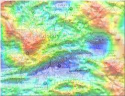
Further, such an evolution would impose a structural framework inherited from lineaments within the basement. It is reasonable to expect that such weaknesses would be remobilised under appropriate stress conditions, and it is interesting to speculate how the basement may have responded to the glacial loading of the crust to its north, during the Pleistocene. This could be one explanation for the linear sections of dry valleys and tributaries of the River Thames having the fractal characters of a shear zone. The model provides a framework against which the known geology of the London Basin and its anomalies can be tested. Everyone, from any walk of geology, can contribute their particular piece of evidence to the picture.