 Mary Harris recounts her mother’s role in investigating the geology of Singapore
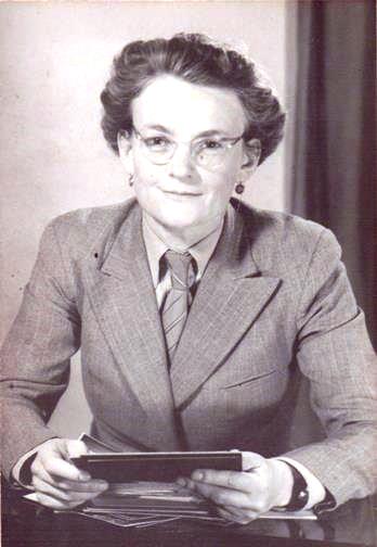
Much of the current geological work in Singapore has developed from the work of Dr Elizabeth Alexander (pictured, left): particularly from that published in her
Granite Report of 1950
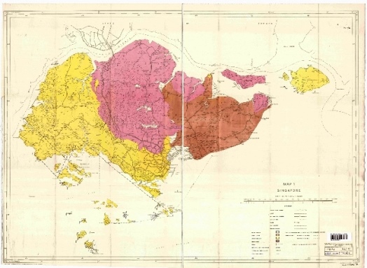
1 with its enfolded map (below). She had come to Singapore in 1936 with her husband, New Zealander Norman Alexander, Professor of Physics at Raffles College, but began research on the island's geology under her own initiative almost as soon as she arrived.
Malay States
In the colonial era, Singapore was included with Malaya in a complicated organisation of Federated and Unfederated Malay States and Straits Settlements, and the only comprehensive publications on the geology of the region were those of John Brooke Scrivenor, appointed first Director of the new Geology Survey Department of the Federated Malay States in 1927. He had worked in Malaya since 1903 with a small and fluctuating staff, from headquarters in Kuala Lumpur; but by the time Elizabeth arrived, the Department's headquarters was in Batu Gajah, near Ipoh - accessible from Singapore by road and air - where it remained until after the end of colonial times.
Scrivenor's publications had been accessible to Elizabeth in Cambridge University Library, (where her 1935 PhD in geology is archived) in the Raffles Museum and Library in Singapore, and through the Geological Survey, headed by Eric Willbourn following Scrivenor's retirement in 1931. Elizabeth developed a particular interest in erosion under the warm and humid climate of Singapore, finding that under certain circumstances, iron, aluminium and silica were mobile and were involved in the formation of new rock at unexpectedly high speed.
 Mangrove swamp
Picture: Alexander's geological map of Singapore.
By 1940, she had buried some rock samples in mangrove swamp, to compare some years later with controls in the lab which she had set up in her own home. She was still freelance as a geologist, but by 1938 had begun war work at the Singapore Naval Base, where she was employed in Radio Direction Finding (RDF). At that time the Admiralty was setting up a network of long-range, high-frequency, radio direction finding stations, with Singapore as their control centre. Singapore had particularly close links with New Zealand, whose Navy was still a squadron of the Royal Navy and which, as a country, was well advanced in wireless technology.
Invasion
The Japanese Army invaded Malaya in December 1941 and advanced rapidly down the peninsula. Elizabeth was ordered to take her three children to safety with her husband's family in New Zealand, and to return to the Naval Base with specialist equipment then being manufactured in Sydney. But she was overtaken by events. Singapore fell, and she found herself stranded with no income and no news of her husband and needing to find work so that she could rear her children.
Through contacts with colleagues from Cambridge University days who were by then working in radar (not yet called that, but disguised under the name of ‘RDF’) and her Singapore Naval Base link with the New Zealand part of the RDF network, she was invited to set up and run the Operational Research Section of New Zealand's Radio Development Lab, the secret radar research department of New Zealand's Department of Scientific and Industrial Research.
During her four years there, she was responsible not only for the operational effectiveness of New Zealand's own radars (thrown into prominence in the South Pacific theatre, following Pearl Harbour), but also for two major pieces of research, which faded from history until the very recent publication of New Zealand's WWII Radar Narrative. One became the beginning of the science of radio astronomy in Australia and the other the Canterbury Project.
Elizabeth could proceed with neither of them herself because her contract with the New Zealand government ended with the end of the war. Her husband re-appeared from internment in Singapore and eventually, she herself was back in Singapore in 1947. It is relevant to note however, that her work as Head of Ops Research in New Zealand, in which she was employed as Senior Physicist, was as significant to the development of radio science as her work in the science she loved best was to become in the development of the geology of Singapore.
Recovery

In Singapore in 1947 the priority was recovery from occupation. Continuation of her own research was made impossible because her house, which included her lab, had been looted to complete emptiness by the British Army of Reoccupation. Instead, she worked to help re-establish Raffles College, in various consultancies concerned with Singapore's neglected or damaged infrastructures, and in acting as Temporary Registrar for the new University of Malaya while preparing specimens and slides for teaching in a geology department there as soon as it opened.
Picture: Elizabeth Alexander in the field, Singapore. Survey Museum, London
In 1949 she was commissioned by the Singapore government to survey the Island for sources of granite for reconstruction and to publish the Granite Report named above. Her attempt to restart her own weathering research was further obstructed because, during some road building, the occupiers had sliced the top off a hill which bore a triangulation point, crucial in locating her buried basket of rocks. Then, her husband was head-hunted to Ibadan, Nigeria where University College Ibadan (then an internal college of London University) would need its physics department upgraded in time to undertake ionosphere research for the International Geophysical Year of 1957/8.
Elizabeth was unhappy to leave her own Singapore geology research for a second time, but her husband, affected like all internees by his experience, needed her help and she put him first. At University College Ibadan, she took a junior post in the Agriculture Department under the rule that wives of expatriate staff could not undertake employment if a qualified Nigerian was available, and attempted to start some weathering research again. Meanwhile Michael Tweedie of Raffles Museum, a naturalist with great experience of and fondness for mangrove swamps, found one of Elizabeth's baskets of rocks and had it sent to the Rothamsted Research Station, just outside London, where she could examine the rocks during annual leaves from Nigeria.
Stroke

Her paper
2 was read at the Geological Society, shortly before she died and published posthumously. During an unsuccessful argument with the College Principal at Ibadan for the development of a geology department which she had already set up at her own expense, she suffered a cerebral haemorrhage and died a week later. She was not quite 50 years old, but in her short life, hampered by war and its lasting effects, she had changed thinking in two separate sciences. Then she disappeared from both sciences until, with the publication of the New Zealand Radar Narrative and renewed geological research in Singapore, people began asking who this remarkable scientist was. My forthcoming biography
3 intends to try to explain.
Picture: Kampong Eunos Earth Quarry, showing wind and water erosion. Survey Museum, London (1950)
Elizabeth Alexander would have been particularly pleased to see the lasting effects of her Singapore work both in Singapore and in England. The second edition of
The Geology of Singapore by Lee Kim Wee and Zhou Yingxin, was published in 2009 by Singapore's Defence Science and Technology Agency in collaboration with the Building and Construction Authority of Nanyang Technological University, and made available online through researchgate.net by author Professor Zhou in 2016.

Her work is cited, discussed and developed throughout the book as new generations of Singapore geologists work collaboratively with government departments which need to use it. At the same time, the British Geological Survey is working collaboratively in Singapore in building its three-dimensional model of the island. At a time when so much of Singapore's land has been bulldozed and built on, Elizabeth's 1950 report, map and photographs are the only record of earlier, more accessible geology.
At the same time, her posthumously published paper on tropical weathering in SE Asia has significance for recent work on the Hertfordshire Puddingstone. Lovell and Tubb (2006) suggest that cementation of this famously hard rock took place “…beneath a 55Ma land surface that enjoyed a climate closer to that of present-day Penang (in Malaysia) rather than that of Puckeridge.” 4
Acknowledgement
I am grateful to Professor Yingxin Zhou and Marcus Dobbs for personal communications about the significance of Elizabeth's legacy in their current work.
References
Picture: Elizabeth Alexander, taken in NZ c. 1943, on a day off from Heading the Ops Research Section of the Radio Dev. Lab.
References
- Alexander FES. 1950. Report on the availability of granite on Singapore and the surrounding islands. Singapore: Government Publications Bureau.
- Alexander FES. 1959. Observations on tropical weathering: a study of the movement of iron, aluminum and silicon in weathering rocks at Singapore. Quarterly Journal of the Geological Society of London. 115:123–144.
- Harris, Mary (forthcoming). Rocks, Radio and Radar: the extraordinary scientific, social and military history of Elizabeth Alexander, to be published by Imperial College Press.
- Lovell, Bryan and Tubbs Jane (2006) Ancient Quarrying of Rare in situ Palaeogene Hertfordshire Puddingstone. Mercian Geologist 16 (3) pp185 - 189.
* Mary Harris is writing the biography of Elizabeth Alexander. E:
[email protected]