 Paul Johnson, Society Map Librarian, tells the story of the Society’s maps
The story of the Geological Society’s map collection is one of boyish enthusiasm, occasional rivalry, a bit of showing off, and a never-ending quest for additional storage space. Over time, the Society has gone through phases of voracious map acquisition through to disdain and neglect of them. It has never really quite known what to do about these cumbersome sheets, but it finds them both beautiful and incredibly useful. In the two centuries of the Society’s existence, they have given a pantheon of geologists a God’s-eye view of field, formation and fault-line.
UNABASHED
From the outset, The Geological Society has had an unabashed love of maps. The first Committee of Maps was created in 1809, barely two years after the foundation, demonstrating an early eagerness for committees and maps, both of which continue to this day. Even before that date, several sheets had been presented to the Society - including works by Sir Joseph Banks and George Bellas Greenough.
In these early years the interest was in discovery. New maps brought new realms and new evidence to the meeting-room table for the gentlemen of the Society to debate. Years go by, the cartographic collection expands, the needs of Empire develop. There are railways to be driven and coal to be mined. The same maps that were drawn for academic inquiry become tools for industry. Whenever schisms have developed between the academic and commercial, throughout the history of the Society, maps have united them.
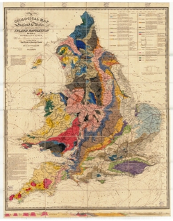
On occasion maps have played a part in rivalries between members of the Society. Perhaps the Society’s most prized map (and dare I say possession?) is William’s Smith 1815 ‘A Delineation of the Strata of England and Wales…’ The Society first received a copy of Smith’s map on 2 June 1815, two months ahead of its publication date. In 1828, the sooty thumbprints of the fellowship were too numerous, so the Council ordered it to be varnished, framed and displayed on the wall of the meeting room. There it joined Greenough’s 1820 map of England and Wales which had enjoyed sole occupancy of the meeting room’s wall for the previous year.
 DISTANCE
At the time there was something of a distance between William Smith and the Society. The maps, published five years apart, were a particularly sore spot. It has been claimed that Greenough’s map owes more than something of a debt to Smith’s earlier work, a debt acknowledged on the posthumously published 3rd edition of Greenough’s work. Within the society of 1828, the primacy of Greenough’s map, in its lofty position within the Society’s new Somerset House, apartments demonstrates how things stood at that date.
Of the two maps, only Smith’s has had books and TV programmes devoted to it. With its celebrity came public demand for viewings. Currently there is nothing behind the curtain that protects the map from the sun. The map is presently enjoying the company of a J M W Turner and a Barbara Hepworth at the front of the summer exhibition in the Duveen Galleries of Tate Britain. Attending the exhibition allows the viewer to get closer to the map than usual and instead of gazing up from below, it is currently possible to examine it in finer detail than is usually the case. Nor is this the first occasion on which Smith’s map has enjoyed a holiday by the Thames. During the Festival of Britain, the Society took the chance to show off its cartographic wonder and the map took its place in ‘The Earth’ section of the Dome of Discovery on the South Bank.
 LARGE BOMB
Ten years prior to the Festival, the map collection was being put to far more practical usage. The Society remained open during the war despite all of its windows having been blown out by a large bomb that detonated in St. James’s churchyard. Buffeted by the blitz, our maps were being studied in the search for new oil supplies within the UK. Other subjects for the men from military were the suitability of sites for airfields and latterly (the window glass still not replaced), terrain in Normandy was investigated in the search for suitable beachheads.
These wartime geologists would have relied on the work of Thomas Sheppard FGS, who ensconced himself in the library and systematically recorded everything he could find. When the Society was in its infancy, annual lists of the library holdings were published, and made available by subscription to users. This practice fell into disuse as the list became longer, the number of subscriptions diminished and it became burdensome to the Society’s coffers. Subsequently, the cataloguing of the collection fell into relative neglect.
Mr Sheppard’s comprehensive list was compiled from the 1910s and used within the library for some time afterwards. Only the UK portion of that list now survives. Post-war, the cataloguing of the map collection was again left unattended. The redoubtable Mrs Nutt, Chief Librarian, had a brave stab at remedying the situation, before - in the 1980s - Wendy Cawthorne took up the reins and started indexing the maps properly. Meanwhile, Mrs Nutt’s successor Sheila Meredith lobbied for a dedicated Map Librarian to put the maps into a state of order once and for all. I am the fourth person to have held that position and the entire map collection is searchable via the catalogue on our website.
SPACE
 Cataloguing an unruly map collection is one thing. Housing it is quite another. From the beginnings of the Society the map collection has pressed for more and more space. Maps demand cabinets, demanding room and expenditure. Often, used maps were dissected and mounted on linen to be stored folded in ranks of green boxes upon the Library shelves. Rarer, more delicate works lay un-creased in drawers. When the Society expanded into rooms vacated by chemists in 1971, a Map Room was created. Rather intimidating vertical map presses were purchased (and only screwed to the floor 20 years later, after several near misses involving the combined weight of several hundred maps toppling to the floor). Together with various cupboards and storerooms in the basement, the Society’s entire map collection is still housed in the Map Room. Although it is getting rather full…
One area of map librarianship that hasn’t been given much thought by the Society, is that of preservation. The varnish that was applied to Smith’s map in 1828 did not preserve it well, and may even have damaged it. It was replaced in the 1930s with another copy. The same is true of its wall-mate. When maps of the collection became too badly damaged, they were disposed of rather unceremoniously - and were in some cases destroyed. Despite this, the map collection now has more than 40,000 sheets, nearly all on paper.
If these maps are to remain useful in an era of digital cartography and GIS systems, they need to be scanned to preserve them. Some of the historic maps in the collection have already been scanned and are available as prints from our website. Please go to www.geolsoc.org.uk/mapsale. The Society is currently drawing up plans for the rather grander task of digitising all of its maps, to ensure the longevity of this treasure for years to come.
Acknowledgement
In compiling this piece I am indebted to Wendy Cawthorne for her assistance, and to Gordon Herries Davies’s book ‘Whatever is Under the Earth: The Geological Society of London 1807-2007’.