Product has been added to the basket

Santorini run

The author crosses the line at the London marathon

In the second of this short series on holiday volcanic islands, geologist and runner Nigel Platt remembers Santorini.


Geoscientist 20.11 November 2010


A cold January in London is always the perfect time to head inside. One such Sunday found us at the British Museum, gazing at a small statue that transported us to a different world. Inside the case, an acrobat was jumping over the horns of a charging bull — a feat of agility captured in Bronze Age craftsmanship more than three and a half thousand years ago.

And so we decided on Santorini. A few short months later, it was early morning and the sun was already hot across the blackness of the beach. To the south, the road snaked its way up the cliff to Ancient Thera. It’s one of the most beautiful places on Earth; but the climb of Mesa Vouno would have killed me long before I got there. So instead, I headed north along the shore, the Aegean on my right, and work my way slowly out of the resort of Kamari. The strip was quiet at that time; just a few old folks up, foraging for breakfast. The rest were sleeping off the night before. The deserted hotels and bars fell swiftly behind, and soon I reached the end of town and the start of Greece.


South aegean arc and tectonic setting of Santorini It’s peaceful running here. Beside the road, straggly vines drape across the ground, Santorini-style. I trot past a cluster of pines, round a corner, and a vista opens. Beyond the airport to my left, the horizon rises evenly through sparse brown fields. The white town of Pyrgos stands atop the hillside, looking out to Fira on the crater rim, and the tourist trail to Oia. Nothing is flying yet, though a few cars drift past, carrying holiday workers to their travel agencies and hotels. Ten minutes go by as the day grows warmer and my legs steadily measure out the long road beside the runway.

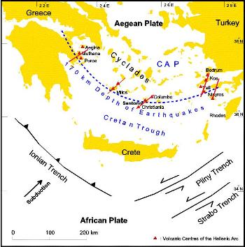
The church of Agios Ioannis (St John) lies up ahead. Not far beyond lies the pretty beach of Monolithos, with Vourvoulos hidden further on. Quiet, dreamy hideaways these, floating in the forgotten corners of a tourist island — yet still recalling the violent history of this place. Because this landscape, between Ancient Thera, Pyrgos and Monolithos, formed around a smaller, older island that was buried by a series of cataclysmic eruptions throughout the past 200,000 years.

The road to Vourvoulos cuts through cross-bedded volcaniclastics, stuffed with vicious-looking volcanic bombs, each more than big enough to kill a man. Dating from an early eruption, these rocks fell long before recorded human history. The main event occurred 40,000 years later, around 1645BC, when the Minoan civilisation ruled the eastern Mediterranean. But their archaeological record is scant, perhaps consistent with the geological catastrophe that destroyed their power.


Caldera Structural SettingEven the eruption of Krakatoa in 1883 scarcely holds a candle to events on Santorini, where the start of the main eruption saw the ejection of an ash column 36km high, covering the island in a blanket of pumice up to five metres thick and spreading an ash cloud all around the Eastern Mediterranean.

A second phase saw boiling pyroclastic flows spread out across the ground at up to 180 kilometres per hour. The flows were 10m thick and draped relief up to 400m high. Seawater breaking into the crater set off violent phreatomagmatic explosions, sending huge angular chunks of basalt high into the sky and raining back to Earth. Yet more ash fell up to 40m thick around the crater edge in the third eruptive phase — these rocks containing clasts up to 10m across. Finally, reworking of material from the eruptive cone laid down clastic fans up to 40m thick across the coastal plains.

In all, the eruption saw the extrusion of at least 35 cubic kilometres of rock. The sound of Krakatoa was heard 5000km away, so we can assume that the Santorini blast echoed across the ancient world. Surrounding coasts were likely devastated by terrible tsunamis. Throughout the Aegean and eastern Mediterranean, it would have been dark for days (or even weeks, or months) as the ash cloud spread east and southeast on the prevailing wind. On Santorini, the eruption buried the Minoan settlement at Akrotiri in a thick layer of pumice. Further beyond, in Crete, tsunami damage to harbours and ships may be one reason for a dramatic weakening in the Minoans’ wealth and influence, which led to their conquest by the Myceneans not many years after.


Cross bedded and channelised volcaniclastics, Vourvoulos, Santorini I climb the hill to the church, and look out across a blue expanse of Aegean Sea. Minoan trading ships called here, 4000 years ago. After the Myceneans came the Dorians, who founded ‘Ancient’ Thera around 900BC. Then came Greeks, Spartans, Romans (later Byzantines) and Franks. The Venetians named the island for Saint Irene. Then the Ottomans arrived, before Santorini gained independence in 1821 and joined Greece nine years later. I turn and gaze back. New visitors fly here now, not in conquest but to witness some of the most spectacular sunsets on Earth.

The pretty towns on the ridge surrounding the caldera are as beautiful as anywhere I have seen, their outlook made all the more majestic by views of the slowly rising fresh volcanic island of Nea Kameni, far below. A new shield volcano is steadily building there - towards Santorini’s next devastating eruption.

I kick my heels again, down past the airport and back beside the beach. The heat of a Greek summer’s day is building through five hot kilometres to Kamari, and my legs tire with every footfall. Another day can start now, beside the pool in the morning and an afternoon swim at Monolithos. The memory of a hot 10km run on Santorini will brighten some future London winter’s morning like Keats’s “beaker, full of the warm south”.

Sunset over the Caldera