Product has been added to the basket

Fieldwork in the Libyan Sahara

Fig 8 - Sandfield at the western margin of the Kufra Basin.

Guido Meinhold and Daniel Paul Le Heron* describe the geology of one of the world’s most hydrocarbon-rich countries, together with the joys – and rigours - of working in the desert…


Geoscientist 20.11 November 2010


Libya is one of the most hydrocarbon-rich countries in the world. Its large oil and gas reserves make it attractive to international oil companies, which provide the impetus for field-based research in the Libyan Sahara.

Libya is bounded to the north by the Mediterranean Sea, to the east by Egypt, to the south by Sudan, Chad and Niger, and to the west by Algeria and Tunisia. At approximately 1.8 million square kilometres, Libya is the fourth largest country on the African continent, or about seven-times the size of Great Britain, but has only a tenth of the population (six million).

This is perhaps not surprising as about 90% of Libya belongs to the Sahara: one of the hottest and driest places on Earth (Fig. 1 - image below). The excitement of exploring this remote and often dangerous landscape has attracted several generations of geologists. Between 1920 and 1940, the famous Italian geologist Ardito Desio Hon FGS (1897-2001) set important milestones, producing the first geological map of Libya, discovering the trace fossil Bifungites fezzanensis, and initiating the oil and gas exploration in Libya. Libya is now regarded as a global hotspot for hydrocarbon exploration.

Fig. 1 Landsat image showing Libya and surrounding areas (Source: http://zulu.ssc.nasa.gov/mrsid)

How Libya was made


North Africa is made up of several enormous intracratonic basins, two of which are found in southern Libya. The Murzuq Basin, in the southwest, and the Kufra Basin, in the southeast, together cover almost 800,000 km2: about 3.5 times the total land area of the UK. Both basins are filled with Palaeozoic and Mesozoic clastic sedimentary rocks up to 5km in thick. These basins developed from the Cambrian onwards following an earlier period of orogenesis (the Panafrican Orogeny) in the Neoproterozoic (~900–540 million years ago).


Fig 3 - Panafrican basement in southern Libya, a few kilometres north of the border with Chad. Precambrian metasediments and granitoids (Fig. 3) are unconformably overlain by Cambrian and Ordovician conglomerates and sandstones. They show a transitional environment from continental to shallow marine. Sandstone bearing the trace fossil Skolithos is common in Ordovician strata (Fig. 4). During the Middle Ordovician, an ice sheet began growing on Gondwana, reaching its climax during the Late Ordovician. Melting of this ice sheet in the latest Hirnantian (about 445 million years ago) released large amounts of meltwater and sediment, which were transported to the periphery of Gondwana. In Libya, these sediments are predominantly highly mature sandstones, which in many places form excellent hydrocarbon reservoirs. Polished and striated surfaces in these sandstones clearly point to their glaciogenic origin (Fig. 5).


Fig. 4 - Skolithos-bearing sandstone of the Middle Ordovician shallow marine succession. Following Late Ordovician deglaciation, black shale deposition occurred in the Silurian, with some of the shales being characterised by high organic carbon. These shales are commonly referred to as ‘hot shales’, and are the major source rock for Early Palaeozoic-sourced hydrocarbons in North Africa. Both the Late Ordovician glaciogenic sediments and the Early Silurian ‘hot shales’ are hence a main focus of geological research in the Libyan Sahara. Fluvial conglomerates and sandstones of Devonian age, which occasionally contain plant fossils, unconformably overlie these strata. Further up in the Devonian, marine intervals are more common, and the Carboniferous is characterised by shallow marine clastic sediments with carbonate horizons. Permian rocks are only known from subsurface drill cores and comprise continental and deltaic facies.


Fig. 5 - Late Ordovician glacially-related sandstones with polished and striated surfaces. In the basin centres, the Palaeozoic succession is concealed by up to 3km of Mesozoic–Cenozoic strata. The lack of vegetation means that satellite images often provide spectacular insight into the geology. For example, huge volcanic centres of Miocene to Pleistocene age can easily be mapped throughout Libya, from the western margin of the Kufra Basin (Tibesti Massif), northwest toward the Al Haruj volcanic province in central Libya, and further still to the Nafusa Mountains south west of Tripoli. The most famous volcano of all is Waw an Namus in south-central Libya (Fig. 6 - below). Its name translates as ‘Mosquito Crater’, which perhaps needs no further explanation. Waw an Namus sits in a caldera c. 4km in diameter, with three salt lakes in the centre. It is surrounded by a field of black tephra and has an ash tail that extends about 140km to the southwest, providing evidence for palaeowind direction during the eruption.

Today, the Libyan Sahara is one of the most hostile places on Earth. Yet several thousand years ago, the situation was very different. Along the shorelines of mega-lakes, lush vegetation allowed a diverse fauna to flourish. These included buffalo, gazelle, giraffe, elephant, crocodile, ostrich and many others. Prehistoric artefacts and stone carvings (Fig. 7) show that early modern humans wandered around the Libyan Sahara more than 100,000 years ago, admiring and hunting these beasts.


Fig 6 - Waw an Namus volcano in south-central Libya.
Fig. 7 - Ancient carving in southern Libya, a few kilometres north of the border with Chad.

Squeezing information from rock


Understanding the timing of basin formation and important phases in early basin evolution (e.g. development of unconformities) is important in shedding light on whether the Early Palaeozoic basin succession is really “layer cake” or more complex. Knowledge of these processes is essential to understand both the development of the intracratonic “sag basins”, and critical in working out time of formation for potential hydrocarbon traps. Also important is the search for source rocks. Because most of the Early Palaeozoic succession in southern Libya is largely barren of fossils, heavy mineral chemostratigraphy must be used for correlating surface outcrops in the Kufra and Murzuq basins.

Many boreholes have been drilled in the Murzuq Basin over the last 50 years; seismic data have been collected and hydrocarbon reserves are proven (in complete contrast to the Kufra Basin). While draas and large dune fields pose a challenge to any exploring field geologist (Fig. 8 - below), excellent exposures occur at the basin margins. Besides the investigation of outcrops, samples are collected for heavy mineral provenance, source-rock analysis and biostratigraphy. Isotopic analysis (e.g. U–Pb dating on zircon crystals) is used to constrain the age of the Precambrian basement and the overlying sedimentary strata, and to better understand sediment transport paths across North Africa. Extensive sample collection provides a solid base for follow-up analyses. Unfortunately, all outcrop samples are heavily weathered, making collection of fresh specimens very difficult. However, the drilling of shallow boreholes (c. 70m) can overcome this.


Fig. 8 - Sandfield at the western margin of the Kufra Basin.

Desert exploration


There are two time-windows when Saharan fieldwork is possible: February-April, and October-December. During these months, the temperature does not normally exceed 30°C, although the nights can become very cold and windy. In April, ferocious sand storms become quite common.

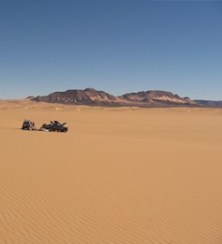
If you don’t want to travel by camel (or walk!) then the only way to get about is by 4WD. An ideal set-up is a small group, comprising two or three vehicles: one for the geologists and equipment, and the other for food, fuel and – the most important of all – water. Small means flexible: any campsite can be moved and set up in very short time. Aspiring Saharan geologists should set up camp in daylight and never at night because snakes and scorpions make uncomfortable company in your sleeping bag. These desert inhabitants are some of most dangerous animals you might encounter. Snakes normally escape before you even see them. Scorpions are more problematic. They hide under rocks and do not move when you approach them. Rocks should always be moved with a hammer or a fully booted foot.

The other worrying issue is unexploded landmines, which are found not only at the borders to Chad and Niger but also in central Libya, north of the Tibesti Massif. It can be an unsettling experience to drive along a previously “forbidden road”, as marked on your official road map, as we did in April 2009. Finally - the intense sunlight makes it imperative to cover up in light-coloured clothes with long sleeves, a sun hat, and plenty of sunscreen. It is also important to drink small amounts of water at regular intervals, since dehydration leads to irreversible damage to internal organs.

Despite all of this, by following some simple rules and being aware of possible dangers, you can easily enjoy life in the desert - much of which is virgin geological territory with stunning scenery. After traditional Libyan stew and couscous, you will reflect on the day’s adventure with a glass of green tea. Sleeping in the open air on the desert sands, you will count shooting stars in the sky and during the long nights, plan the next productive field day in the Libyan Sahara.

Acknowledgements


This work is supported by the Libyan Petroleum Institute and the Earth Science Society of Libya, and funded by a consortium of subscribing oil and gas companies. All of them are gratefully acknowledged for their support of the Southern Basins of Libya study.

Further reading

  • Hallet D 2002. Petroleum Geology of Libya. Elsevier, Amsterdam, 1–508.
  • Le Heron DP, Craig J and Etienne JL 2009. Ancient glaciations and hydrocarbon accumulations in North Africa and the Middle East. Earth-Science Reviews, 93, 47–76.
  • Lüning S, Craig J, Loydell DK, Štorch P and Fitches B 2000. Lower Silurian ‘hot shales’ in North Africa and Arabia: regional distribution and depositional model. Earth-Science Reviews, 49, 121–200.
  • Tawadros EE 2001. Geology of Egypt and Libya. Balkema, Rotterdam, 1–468.
  • Information on the Southern Basins of Libya study is available under www.casp.cam.ac.uk.

* Guido Meinhold is Research Geologist at CASP, University of Cambridge; Daniel Paul Le Heron is Lecturer at the Department of Earth Sciences, Royal Holloway University of London.