Geoscientist 18.11 November 2008
About four billion years ago, lakes on Mars may have been fed by short-lived rivers fed by precipitation. Water accumulated where rivers broke through impact crater rims, and deltas formed at their mouths, just as they do on Earth today.
The findings were reported to the APSC in September by an international team of researchers led by Ernst Hauber (Deutsches Zentrum für Luft- und Raumfahrt - DLR). The researchers had analysed image data from the martian surface, finding deltaic sediments relatively unaffected by erosion inside craters in the Xanthe Terra area, near the planet's equator, in the martian highlands.
"For years scientists have suspected that the current appearance of the landscape has, in part, been shaped by rivers that cut into the surface" said Hauber, a geologist working at the DLR Institute Institut für Planetenforschung, Berlin-Adlershof. The results will be published in the journal Planetary and Space Science shortly. “We can see layered sediments where these valleys open into impact craters. The shape of certain sediments is typical for deltas formed in standing water."
The researchers analysed images from three Mars spacecraft, including the German HRSC stereo camera on board the European Mars Express mission, the Mars Orbiter Camera (MOC) on board NASA's Mars Global Surveyor Mission, and the HiRISE and CTX camera experiments on board NASA's Mars Reconnaissance Orbiter (MRO).
The HRSC, which is operated by DLR, enables the high-resolution and "3-D" representation of large contiguous areas. So-called digital terrain models can be derived from these and the topography of the Martian landscape calculated. Data recorded by the HiRISE camera on board the MRO make it possible to explore selected areas and shows details not much more than one metre in size.
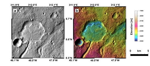
The Xanthe Terra highlands are crossed by deeply incised valleys. Scientists have long suspected that these formed by water erosion. A particularly beautiful delta can be found here in a small crater with a diameter of only five kilometres. The Nanedi river opens into the crater from the south (in the lower part of the image), where the sedimentary material is distributed over a fan-shaped area. The crater is almost completely filled with sediments. Topographic data derived from the stereo images recorded by the HRSC camera show that the layer of material is at least 50 metres thick and the deposits cover an area of about 23 square kilometres.
Very thin layers can be seen along the edge of the deposits. Such thin layers are also typical for deltas on Earth. A particularly interesting discovery is the small valley which leaves the crater towards the east (towards the right in the image). This provides evidence that water must have indeed been "standing" in the crater. "If the water flowed into the crater and back out again, it must have filled it up as well", says Hauber. He points out that it is quite rare to see something like this on Mars: "In this and in a few other cases, we are fairly certain that there were lakes on Mars".
Time lines
The researchers can also narrow down the period when the craters were filled with lakes. In order to do so, they analyse the statistical distribution of impact craters of different sizes to give an indication of the age of a planetary surface. The more craters counted, the older the area. These counts revealed that water was flowing through the valleys between about 4 and 3.8 billion years ago.
The valleys themselves could have formed relatively fast. Maarten Kleinhans (University of Utrecht) calculated that depending on the water volume, the deposits could have formed over a period ranging from decades to millennia. According to Kleinhans, even if the water flow was very low, it would not have taken more than a few hundred thousand years for the deltas to reach their current dimensions. Compared to other geological timescales, especially in planetary geology, this is a very short period.
The findings are strongly indicative of precipitation on Mars, which then flowed over the surface. "This is actually not at all self-evident: for a long time, scientists have been trying to figure out whether the valleys on Mars were formed by groundwater seepage and headward erosion, or by surface runoff caused by rainfall or snowmelt", said Hauber. In recent discussions, the role played by surface runoff has been re-emphasised. "Our findings also point in this direction and we are convinced that both processes have played an important role in Xanthe Terra".
However, some time between 3.8 and 3.5 billion years ago, the precipitation became less intense and the valleys dried up. Erosion on Mars has been minimal ever since, which has contributed to the fact that deposits can still be observed although they should in fact be very susceptible to erosion.