 David L Griffin* tells a story of pioneering exploration and a new interpretation by a pioneering sedimentologists and military geologist.
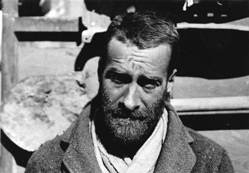
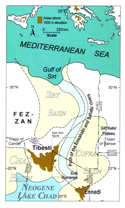
Just over 80 years ago Ralph Bagnold (Brigadier Ralph Alger Bagnold, FRS OBE, 1896-1990, right) and seven colleagues (see photo, bottom) embarked on a 9600km journey of exploration in the Libyan desert (eastern Sahara). The journey took them to the eastern flanks of the Tibesti into an area that has been a focus of my own interest for the past 16 years. I have argued that the area records past fluvial activity mainly of Messinian age (7.2-5.3Ma), when a substantial river system drained from a large lake in the Chad Basin northwards to the Gulf of Sirt.
Image: The Libyan desert showing the route of the 1932 Bagnold expedition. The party crossed westwards from the Nile valley to the flanks of the Tibesti mountains and then travelled south to the Darfur region of Sudan. The return to Cairo completed a 9600 km journey, including 1600km for refueling. MrSid Landsat mosaic 1990.
The

se Sahabi rivers were a western counterpart to the Nile rivers and both originated at about the same time (late Tortonian). The two river systems tell us much about the Messinian climate of NE Africa at a time and place when our own lineage was separating from its hominoid heritage.
Here I give a brief account of the 1932 Bagnold expedition and those parts of it that traversed this now degraded western drainage system. A quirk of boundary drawing (the Sarra Triangle) led the explorers to this area, and conflicting priorities led to the origin of Bagnold’s grumpy but no doubt affectionate nickname (‘On On Baggers’
EXPLORERS
September 27, 1932. With Ralph Bagnold in the lead, Guy Prendergast, Hugh Boustead, Rupert Harding-Newman, Vernon Craig, Donald Paterson, Bill Shaw and Kenneth Sandford left Cairo in four Model A Ford cars to explore and map the area west from ’Uweinat to the Tibesti Mountains and north western Sudan.
The first six were taking a break from Army duties to pursue an interest in desert exploration using reasonably priced, simple, solid, easily repaired Ford cars. The travellers financed about half the cost; the Royal Geographical Society and Oriental Institute, University of Chicago financed the balance.
Ralph Bagnold is best known to geologists today for his work on blown sand and sediment transport in water. He had equally distinguished careers in desert exploration and the Army leading the Long Range Desert Group which harried the Italians and Rommel during WWII.
SARRA TRIANGLE
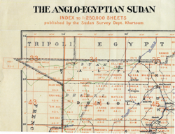 Image: In 1932 the Sarra triangle of Sudan separated Libya (shown as Tripoli) from French Equatorial Africa (present day Chad in this area). Sudan Survey Department map, 1932. Route of the 1932 Bagnold expedition has been penciled in, probably by Bagnold. CACC, BGND D171.
October 15. The party reached the Sarra well, located on the old caravan route north to Kufra. A square well mouth in flat open sand caps a shaft two metres in diameter descending 60m to water. The Senussi dug the well by hand in the late 1800s.
The Sarra Triangle was a westward projecting piece of Sudan that separated Libya and Chad. It had been subject to various claims by Italy, France and Britain. The matter was settled in 1934, with Libya acquiring the disputed territory.
The Bagnold party met with pleasant surprise at Sarra. Major Lorenzini and an Italian contingent were camped at the well. The major insisted on Italian hospitality and so Italians and Brits enjoyed a feast of chicken, spaghetti and Chianti on an improvised table under the stars.
 HAMADA IBN BATTUTAH
Image: Index map
October 16. The party arrived at a high point on northern Hamada Ibn Battutah. Bagnold described the approach to the site: "We entered a most dismal region - of coaly black plateau strewn with broken slabs of very hard silicified sandstone … The remains of human occupation in some past fertile age…only served to emphasize the utter barrenness of the present surface."1
The plateau of Campsite 20 passed abruptly to the west by a big inclined escarpment 60 to 90m high. Here Bagnold commented: “To the westward a sandy depression stretched away from the foot of the cliffs as far as we could see, and appeared to be a broad valley draining towards the north”.2 Bagnold thus observed the broad palaeovalley of the Sahabi rivers.
LOST RIVERS
October 17. The party descended the scarp with difficulty, Bagnold losing an exhaust pipe in the process. The team now partly crossed the valley of the late Miocene Sahabi rivers 3,4 in an approximate westerly direction soon encountering a formidable barrier of sand dunes.
They turned southwest to follow the dunes for 50km at a distance of about four to five kilometres. In so doing they were cutting across the channels of the Sahabi rivers on the flank of HIB West. Evening Campsite 21 was close to the westernmost point of the expedition. To the west were the great peaks of the Tibesti.
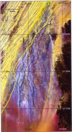
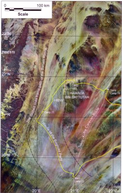 Image: The eastern Tibesti showing the path of the Sahabi rivers and the route of the 1932 Bagnold expedition in the area. HIBW - Hamada Ibn Battutah West. MrSid Landsat mosaic 2000.
The country just traversed was remote and challenging and Bagnold was anxious for the cars. Spokes were bent and broken and a serious crack developed in a major engine bracket. Prendergast and Harding-Newman spent most of the night swapping engine brackets.
The following day the team pushed on for a further 40km in rocky country that became so difficult that a decision was made to turn southeast. The group had reached the northern end of the area of prominent wind eroded grooves that surround the southern end of the Tibesti. In Bagnold’s colourful words: "The grooves and corrugated sand in them resemble the hollow of the roof of a dog's mouth. We could not drive along the teeth of the rocks nor along the sand in between".2
The going improved greatly as the party moved to the east, Bagnold being grateful to geologist Sandford for his insight. The gentle downslope 200km to Tekro were covered with relative ease. The just completed 320km western arc of the journey had traversed the Sahabi river system, the Tibesti Mountains serving to define the course of both rivers and men. Two nights were spent at Tekro, a small oasis south of Sarra.
SAND PEOPLE
October 20. The northeasterly route back to ’Uweinat soon crossed the sand filled, graben-like Erg Idrisi. Happily the dune orientation was close to the direction of travel. To the north of Erg Idrisi lay a small sand sea with dunes separated by areas of sand billows.
Image: Hamada Ibn Battutah West showing the eastern and western channels of the Sahabi rivers and the route by which the 1932 Bagnold party crossed the hamada. 1988 Landsat image.
In hollows between the dunes were stones of many sizes. There were clear signs of past human habitation with grinding stones, pestles, innumerable stone implements and querns. The ground of the habitation sites was invariably soft, leading Bagnold to comment: “Thus we were stopped almost involuntarily, almost mysteriously, by the agency of these folk, who had contaminated the sand with their ashes and refuse. Then as soon as we had urged the cars on to firmer sand … Shaw and Sandford (anthropologist and geologist) would wander off looking for the choicest specimens”.5 Thus the term “On On Baggers” originated as the two collectors had to calm their enthusiasm with muttered comment.6
October 23. On leaving ’Uweinat the journey was close to the halfway point after almost a month of arduous driving. The remaining 4800 km enabled the exploration of northwestern Sudan as far south as El Fashir in Darfur and included the search for a rumoured oasis north of Merga as the party returned to the Egyptian border.
The group reached Wadi Halfa on the Nile on November 19 (the official end of the journey) and Cairo, with cars intact on November 29 having traversed the length and breadth of the Libyan desert - a remarkable feat indeed.
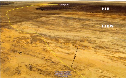 Image: The path from Camp 20 on Hamada Ibn Battutah (HIB) across the western part of Hamada Ibn Battutah West (HIBW) following about 4-5 km to the east of significant sand dunes. The path crosses the defined western channel (WC) of the hamada in the foreground. Base image from Google Earth.
Bagnold and his men would be aware of the many objectives they had achieved on their 9600km journey. One they were not aware of was that they were the first scientists/explorers to traverse 320km of a c. five to eight million year-old trans-Sahara river system. The Sarra triangle had pointed the way.
References
- Bagnold R. A., 1935. Libyan Sands. Travel in a dead world. Hodder and Stoughton, London.
- Bagnold R. A., 1933. A further journey through the Libyan desert. The Geographical Journal 82(2),103-126.
- Griffin D. L., 2006. The late Neogene Sahabi rivers of the Sahara and their climatic and environmental implications for the Chad Basin. Journal of the Geological Society, London 163, 905-921.
- Griffin D. L., 2011. The late Neogene Sahabi rivers of the Sahara and the hamadas of the eastern Libya-Chad border area. Palaeogeography, Palaeoclimatology, Palaeoecology 309,176-185
- Bagnold R. A., 1933. Into the Libyan Desert III. The desert’s lost peoples. Daily Telegraph, London, February 17.
- Kelly S., 2002. The Hunt for Zerzura: the lost oasis and the desert war. John Murray, London
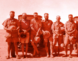
Image: L-R Donald Paterson (position finding, wireless operator), Kenneth Sandford (geologist, archaeologist), Guy Prendergast, (transport, collector), Bill Shaw (archaeology, botany, navigation), Hugh Boustead (collector, hunter) and Rupert Harding-Newman (vehicles, transport). CACC, BGND E 16/3