Jonathan Paul* explores the tempestuous relationship between London and her most precious natural resource.
 Water has captured the collective imagination of London through the generations. The peculiar geology of the London Basin has recently propelled the troubled relationship between London and its water resources into the national spotlight. London sits on the axis of an approximately E-W trending syncline, formed in the late-Oligocene to mid-Miocene. Cretaceous chalk is the major aquifer, approximately 60m below the surface of central London. However, across the London Basin the depth to chalk varies greatly, mainly due to the presence of numerous small faults which cross-cut the syncline. The resultant horst blocks and dome structures have led to localised areas of high ground (Hampstead, Blackheath), the chalk even being brought to outcrop through the Lee Valley and around Greenwich and Woolwich.
AQUIFER
The aquifer is confined in the Basin by the London Clay Formation: stiff, homogeneous and highly impermeable grey-blue clays, deposited in marine conditions during Eocene times. Fluvial muds and fine sands of the Lambeth Group and Thanet Sand Formation are present in many places between the clay and chalk, maintaining a hydraulic connection with the latter, forming the main aquifer and sustaining the flow of many rivers across SW London in times of drought.
Aquifer recharge largely occurs where the Chalk crops out in the Chilterns to the north and the North Downs to the south. The Chalk is a heavily fractured rock mass - almost karstic in character, owing to its susceptibility to dissolution as acidic rainwater percolates rapidly through the aquifer to accumulate in large volumes beneath central London.
The Thames is a striking feature in its own right; a thread running through the city, drawing it together. Wordsworth “ne’er felt a calm so deep” while surveying the river from Westminster Bridge; for Oscar Wilde, far from being a mere watercourse, the Thames seemed “holier far than Rome”. Yet its present route only developed relatively recently. As recently as 500,000 years ago, in fact, a much larger proto-Thames drained most of the West Midlands as a tributary of the nascent River Rhine, flowing out across the present-day southern North Sea.
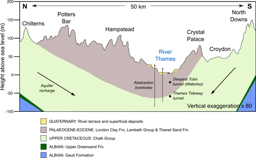
Above: Section through the London Basin, illustrating its asymmetrical synclinal structure.
During the Anglian Stage advance of ice 500,000 years ago, the course of the Thames was diverted southwards. Gravel pits trace out the river’s erstwhile course through Hertfordshire, Essex and Suffolk, and have been extensively worked over the last two hundred years. Contemporaneous with the Thames’ deflection, large dome-shaped, artesian pressure-fed ice volcanoes called ‘pingos’ formed below ground surface. As the ice melted, the subsequent release of hydrostatic pressure injected water and Quaternary-aged gravels into the remaining void, forming a geological curiosity of SE England: scour hollows, which may be up to 500m wide and 60m deep.
SUBTERRANEAN
Back in Greater London, however, the role of man in shaping the course of rivers manifests itself starkly. The relentless growth of the city has smothered many smaller streams under thick layers of concrete and brick. Although most are not visible at the surface, the important influence exerted by London’s vast network of subterranean rivers has been immortalised in a series of evocative street and area names.
Falcon Road, for example, was named for the River Falcon in Battersea; Wandsworth after the River Wandle; or even Water Street in Holborn, the area itself appearing in the Domesday Book as ‘Holeburne’, or ‘the brook in the hollow’. The brook to which the ‘burne’ alludes is the River Fleet, which drains southwards through the district.
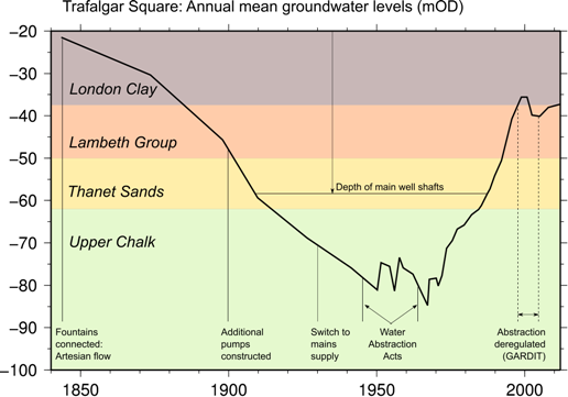
Above: Groundwater levels beneath Trafalgar Square, 1845 – present, with local borehole geology.
London’s subterranean rivers also played a role in shaping the land. The dip at Ludgate Circus, between St Paul’s Cathedral and Fleet Street, is the remanent Fleet Valley, bisecting a Pleistocene-aged gravel terrace of the Thames, across which ran the first road to connect the Cities of London and Westminster. The flat terrace-top afforded the road (now mostly comprising the Strand and Fleet St) a remarkably straight and direct course. However, when engineers were confronted with erosional (as opposed to depositional) features, the opposite occurred. The course of Marylebone Lane is striking in its irregularity, when set against the rigid grid network of surrounding streets. A relatively historical route, it was charted to follow the long-since culverted River Tyburn. Fleet Lane follows the valley of the River Fleet in similarly eccentric fashion.
Although Londoners have historically striven to change the flow of and to hide inner-city water courses from view, their memory persists. It is prudent at this point to introduce another deleterious consequence of London’s population boom upon water resources. Jonathan Swift summarised the River Fleet at Fleet Lane as follows: “Sweepings from Butchers’ Stalls, Dung, Guts and Blood, / Drown’d Puppies, stinking Sprats, all drench’d in mud, / Dead Cats and Turnip-Tops [which came] tumbling down the Flood.”
The Thames contained relatively clean water until the early 1800s. In 1815, household waste was permitted to be dumped in the river, and by the 1840s, this practice became mandatory, with the collapse of the old cesspit system. Virtually all Thames water became contaminated with sewage, leading to cholera epidemics that raged until 1854. Dr John Snow first articulated the link between a contaminated water supply and outbreaks of the disease in Soho, spurring several popular newspaper campaigns for cleansing London’s water. Indeed, the contemporary atmosphere fostered a public drinking fountain movement, with dedicated groups such as the Metropolitan Drinking Fountain and Cattle Trough Association committed to providing free, clean drinking water.
GREAT STINK
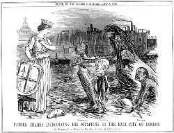 In the meantime, matters came to a head during the improbably hot and dry summer of 1858. The stench of sewage (‘The Great Stink’) became so great that MPs took to stuffing the windows of the Houses of Parliament with lime chloride-impregnated bedsheets. Then-Chancellor, Benjamin Disraeli, described the Thames as “a Stygian pool reeking with ineffable and unbearable horrors”.
Picture: Cartoon from Punch, published during the height of the “Great Stink”: July 3rd, 1858.
Emergency plans were formulated to move Parliament upstream to Hampton Court, or even farther to Oxford; and a Commons Select Committee was appointed to seek potential solutions for “merciful abatement of the epidemic that ravaged the Metropolis.” Eventually Disraeli appropriated £3.5m – a huge sum, even today – to improve the disposal of London’s sewage.
The Chief (Municipal) Engineer to the Metropolitan Board of Works, Joseph Bazalgette, rectified the situation by constructing an 82-mile network of subterranean sewers and drains, the foundations of which remain in use today). The system was officially launched in 1865 at Crossness pumping station in SE London, where four great steam engines raised effluent by 10-13m for discharge to the Thames at ebb tide. The site has since been tastefully converted into a museum.
Getting a degree of purchase on waste and rainwater for the first time and introducing treatment plants at Plumstead and Barking was undoubtedly a major triumph of Victorian engineering. But perhaps more interesting from a geological point of view were the means of construction employed by Bazalgette and his team of engineers, which would revolutionise future ideas of sanitation in the capital and beyond.
Although the London clay through which the tunnels were bored is of low permeability, Bazalgette recognised the pressing need for a strong and durable lining. He therefore used Staffordshire Blue bricks, extremely hard-wearing, with low water absorption, made from the Carboniferous-aged Etruria Marls. Combined with ‘future-proofing’ - boring tunnels of far greater dimensions than were necessary for the time - Bazalgette’s network is only now beginning reach capacity.
THAMES TIDEWAY
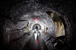
Left: Interior of a typical Bazalgette sewer: River Westbourne, Pimlico.
As a result it has become necessary to drive new, deeper tunnels beneath London, to keep pace with the demands and pressures of population growth. The Thames Tideway project has seen the boring of a 7.2m-diameter tunnel - for the most part following the Thames - entering into the Chalk east of Tower Bridge. Upon completion, an annual 39 million tonnes of untreated sewage will be captured and thus prevented from overflowing into the Thames. Instead, it will be channelled into the deep tunnel, which acts as a vast temporary storage tank.
While the condition of Bazalgette’s sewerage remains excellent, many smaller, more recently installed pipes carrying potable water are currently needing replacement. In many cases, instability of older, rigid iron piping can be related to the composition of the surrounding London clay; specifically, high montmorillonite is known to cause ground heave (large volume changes in response to changes in moisture). This contributes to the 665 million litres of water currently lost daily in the Thames Water catchment area – the greatest loss the UK.
TAPWATER
London is a thirsty city: the average annual precipitation of 590mm is lower than Rome, Dallas, or even Istanbul! Thames Water predicts that by 2035, the regional supply-demand deficit will have more than doubled relative to current estimates. Construction of the Thames Water Ring Main in the early 1990s greatly improved storage and transmission of potable water from water treatment works across London, but was a process plagued with groundwater-related difficulties. Two workers were killed during excavation of a pump-out shaft at Stoke Newington; operations unexpectedly struck the fully saturated Thanet Sands, strata with an abundance of glauconite, which oxides on contact with air. The rapid removal of oxygen by the glauconite in such a confined space ultimately asphyxiated the two workers.
 Zealous water abstraction from the early 19th Century led to a fall in groundwater, increasing the strength of the London Clay, but also resulting in settlement of both the ground surface and of buried tunnels. Rapid decreases in the level of the water table beneath London gained national recognition following the widely publicised settlement of the Bank of England by as much as 0.3 m from 1865-1931.
Legislation in the 1960s – and the general decline of heavy industry - led to the recharge of groundwater levels; indeed they are now roughly stable, or increasing at a rate of up to ~1mm/yr. Increased abstraction is now needed in some areas, as old tunnels are threatened by the slow upward leakage of water through the impermeable clay layer under high pressures. This can lead to an increase in porewater pressure, and a loss of shear strength and bearing capacity – in other words, flooding in unsealed tunnels - and instability in those that are fully sealed, resulting from high uplift pressures. Recent increases in abstraction (under the so-called General Aquifer Research Development and Investigation Team – GARDIT – strategy) have largely established a dynamic equilibrium and brought rising groundwater levels under control.
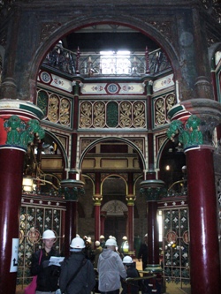
Right: Interior of Crossness Pumping Station, Thamesmead, SE London
HAZARD
The danger of striking a subterranean river or saturated sand stratum when tunnelling is one major hazard brought into focus by the construction of the early cut-and-cover London Underground lines. The top 5-20m of London’s geology consists of unconsolidated, young and highly permeable river terrace gravels and alluvial deposits. Engineers treat these strata as an ‘upper aquifer,’ perched above the Chalk, recharged locally from precipitation. During construction of the Jubilee line extension in 1996, the water level was found to be just three metres below ground level between Westminster and Green Park stations.
Construction of the Victoria Line was delayed at Green Park when the tunnel boring machine(TBM) left the London clay to hit the gravel deposits of the former Tyburn Valley, which collapsed and infilled a large section of the tunnel. Stepping back to April 1862, building of the Metropolitan Line destabilised the weak alluvial subsoil in Blackfriars to the extent that the Fleet Sewer burst, significantly delaying construction. As the Evening Standard reported: “... the populace screamed at the thought of workmen entombed, drowned and massacred … the whole bottom of the excavation moved in one mass. The crown of the arch of the mighty Fleet Sewer had broken.”
In June 2011, Old Street tube station was shut due to flooding. On a stretch of the Northern line, pyrite (iron sulphide) grains in the surrounding strata of the Lambeth Group had been rapidly oxidised by the ‘piston effect’ of passing trains. Seepages of water from the overlying London Clay mixed with the oxidised pyrite to give rise to a sulphuric acid-rich groundwater (so-called ‘aggressive water’): sands with pH as low as 3 were recorded (c.f. average of pH 8.3 under normal conditions). As a result the tunnel lining had become corroded to such an extent as to allow ingress of water. In other areas, engineers have striven to avoid permeable strata. For instance, Northern line tunnels are subject to a violent 90˚ turn and steep upward gradient entering the southern terminus at Morden: manifestations of evading the water-saturated sands of the Lambeth Group to the west and south.
However, careful monitoring and innovative management can bear fruitful results. The use of groundwater as a natural cooling agent is currently under trial at the Royal Festival Hall, Sadler’s Wells Theatre, and at selected London Underground stations. In the early 1900s, the ambient temperature of the Tube was around 15-16˚C – roughly that of the surrounding London clay – contemporary advertisements trumpeting the experience as “The Coolest Place in Hot Weather”. The progressive accumulation of heat over the last century has created a pressing need to cool trains and stations. At Victoria hot air is extracted and run across cold water drawn from the subterranean River Tyburn; a heat exchange takes place before the newly cool air is pumped back into the deep-level Tube station. For a very small environmental impact, this limited trial successfully removes around 60kW of heat from the station.
FUTURE
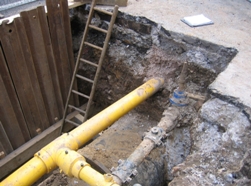 Left: Replacement of old, cast iron water pipes with plastic piping in the London Clay, Southwark.
So where is the changing relationship between London and its water resources leading? Certainly the twin pressures of sewerage capacity and a potable supply-demand deficit have led to many large-scale infrastructure plans, such as the Thames Tideway tunnels, and the construction of a huge £250m desalination plant at Beckton, capable of supplying up to 1 million people in times of drought. A decisive shift in policy towards sustainability and sensitive water management has occurred: in a September 2012 report, the London Assembly acknowledged that “London must use water more efficiently, starting now and increasing progressively in the future”.
Still, problems and ignorance persist. One most urgent issue is the need to change a public perception that London’s water is abundant – the mistaken assumption of London’s ‘high precipitation’, and a failure to decouple ‘weather’ from ‘climate’. The use of geology – specifically the chalk aquifer as a natural filtration system – has also been mooted for nearly a century: “Such a natural [chalk] reservoir does exist, deep under the London clay, capacious enough to hold many times our necessary annual supply, and provided with a natural system of filtration which arrest or destroy impurities and transform the dirty water into a soft water suitable for man and beast” (Evening Standard, February 1924). However, management of the aquifer has historically been problematic. Saline intrusions and high residency times in the syncline beneath central London have rendered groundwater susceptible to pollution.
Water is London’s most precious natural resource, closely tied to the Chalk aquifer, sculpting the capital’s topography and directing its economic growth; yet its importance and the need to safeguard it are often understated. London has only just arrived at a tentative mutual understanding with the chalk aquifer and groundwater, predicated upon past lessons learnt from decades of mismanagement. The future lies in sustainability. Only harnessing London’s water in a sensitive manner will protect Bazalgette’s legacy and once again future-proof London for the challenges ahead.
* Jonathan Paul FGS is a research student at the Department of Earth Sciences, University of Cambridge. E: [email protected]
Further Reading
-
Environment Agency, 2010. Management of the London Basin Chalk Aquifer. Bristol: EA Status Reports.
-
Greater London Authority, 2011. Securing London’s Water Future: The Mayor’s Water Strategy. London: City Hall.
-
Headworth H., 2004. Recollections of a Golden Age: the groundwater schemes of Southern Water 1970 – 1990. Geological Society of London, Special Publications, v. 225, pp. 339 – 362
-
Paul J.D. and M.J. Blunt, 2012. Wastewater filtration and re-use: An alternative water source for London. Science of the Total Environment, v. 437, pp. 173-184, doi:10.1016/j.scitotenv.2012.08.010
-
Ellison, R.A., Woods, M.A., Allen, D.J., Forster, A., Pharaoh, T.C. and King, C. 2004. Geology of London. Memoir of the British Geological Survey (Sheets 256, 257, 270, and 271)