Jennifer Woods and Robert White of the Cambridge Volcano Seismology group re-live the drama of the 2014 Bárðarbunga−Holuhraun dyke intrusion.
 At 0200 on 27 August 2014, five Cambridge University research students at the foot of Askja volcano in Iceland were shaken awake by a magnitude 4.5 earthquake. Normally such a small earthquake is easily ignored. But when that earthquake occurs just 3.5km away in the heart of an active volcano and the reason you’re there is a rapidly advancing underground channel of magma, then there is cause for concern.
Picture: The 2014 Bárðarbunga−Holuhraun dyke intrusion culminated in a spectacular fissure eruption which lasted 6 months. Over 1.4 cubic km of lava was erupted, making this the largest eruption in Iceland in 200 years. Photo by Tobias Löfstrand.
In 1875 a violent eruption of Askja caused the depopulation of the whole of northeast Iceland, so the foot of that volcano was no place to be. This was the situation in which the volcano seismology group from Cambridge found themselves, during intrusion of the Bárðarbunga−Holuhraun dyke.
Subglacial
Seismic unrest began in the giant subglacial volcano Bárðarbunga in summer 2014. On August 16 the activity developed into a dyke intrusion 7km below, advancing north-eastwards. The scientific community, whose eyes were initially focused on other well-overdue Icelandic volcanoes, were quick to respond.
Partners of the FutureVolc project, bringing together researchers from 26 institutions across Europe to improve monitoring and understanding of Icelandic volcanism, were deploying instruments within days. Seismometers and campaign GPS sites were installed across the region and immediately above the activity on the glacier, adding to existing networks already in situ. Glacial outburst flood zones were evacuated and aviation colour codes were increased in threat-level. Satellite images were downloaded, and gas samplers prepared.
 After 10 days and 46km of advance, the underground river of molten rock reached the Holuhraun craters from a mid-18th Century eruption. It was at this point that the Askja volcano asserted itself with a magnitude 4.5 earthquake. Cambridge research students in the field were deploying instruments based on anticipation of an imminent eruption. They weren’t deterred and finished installing additional seismometers around the tip of the intruding dyke just hours prior to its first rupturing the surface in the old Holuhraun lava field. The initial fissure eruption lasted only four hours, but recommenced less than two days later with renewed vigour and greater extent.
Picture: Researchers from the University of Cambridge were witness to the spectacular “curtain of fire”
The eruption persisted for six months, accompanied by deflation of the Bárðarbunga volcano caldera, beneath which the source magma chamber is thought to reside. In the early days the fountains of magma reached over 150m high, erupting 500 tonnes of molten rock every second. The thermal energy was equivalent to that of a Hiroshima atomic bomb detonated every minute. Eventually the lava field covered 84 square km and over 11 million tonnes of harmful sulphurous gases had been emitted.
Scenarios
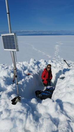
Picture: Partners of the Futurevolc project initiated a rapid response to the onset of unrest at Bárðarbunga volcano. University of Cambridge PhD student Thorbjörg Ágústsdóttir deployed seismometers on Vatnajökull glacier immediately above the dyke. Photo by Ágúst Þór Gunnlaugsson.
There were two major scenarios for this volcanic unrest: molten rock may either have erupted vertically from the parent subglacial volcano Bárðarbunga or continued injecting a lateral dyke underground. The former would have undoubtedly produced widespread disruption across Europe as happened in the 2010 Eyjafjallajökull eruption: the explosive interaction of molten rock at over 1100°C with the base of the overlying ice would have caused instant fragmentation of the magma as it hit the meltwater and almost instantaneous boiling and steam generation would have propelled large clouds of ash ten thousand metres or more into the atmosphere.
In 2010, European airspace was closed for nearly two weeks and over 100,000 flights cancelled as a result of the Eyjafjallajökull sub-glacial eruption. An eruption under the ice-cap may also have caused catastrophic flooding as water trapped beneath the ice burst out and surged down valleys towards towns near the coast.
An alternative and even more frightening scenario was that the melt would keep propagating underground until it met large melt volumes stored beneath the Askja volcano. Travelling at similar depths, the dyke was heading directly for the Askja magma reservoir. It could have triggered a major explosive eruption similar to that of 1875, which devastated northern Iceland. Both outcomes were scary.
In the event, molten rock breached the surface in Holuhraun, before it reached Askja and just outside the ice cap, in an unpopulated area. It then flowed out of the fissures relatively benignly. In subsequent weeks the main hazard became the toxic sulphurous gases it belched out. It emitted more sulphur dioxide over the course of the eruption than the whole of the European Union emits in a year. Gas concentrations breached EU limits as far away as Ireland. The hazard to surrounding towns depended, quite literally, on which way the wind was blowing.
Lessons
Picture: Researchers from the University of Cambridge volcano seismology group maintain a network of approximately 70 seismometers in central Iceland to study the crustal structure and dynamics of rifting.
The extensive scientific observations of the 2014 Bardarbunga-Holuhraun dyke intrusion provide an unprecedented opportunity to understand the physical processes of dyke propagation. Over 30,000 earthquakes accompanied the intrusion of molten rock through the crust. They delineate a segmented dyke intrusion with propagation speeds between 0.3 and 4.7km/h. Local GPS displacements and satellite interferometric data detail the evolution and magnitude of ground deformation caused by the dyke emplacement. They show that a 5m-wide, vertically-extensive dyke had opened. Seismicity, however, was concentrated at 7km depth, suggesting that melt flowed through a channel near the base of the newly opened dyke. In Iceland, episodic rifting episodes like this accommodate spreading between the North American and Eurasian plates, which are diverging at an average rate of 20mm/year.
Researchers in the volcano seismology group at the University of Cambridge are studying the seismicity accompanying the intrusion. Understanding why seismicity arises and what it represents sheds light on the mechanisms of dyke propagation and can be an invaluable predictive tool during rifting events. Another interesting feature under investigation is the effect of stresses imposed by the dyke emplacement. Seismicity is triggered at distances of more than 10km by very low stress-changes which, of course (topically!) has implications for fracking.
Studying rifting in Iceland
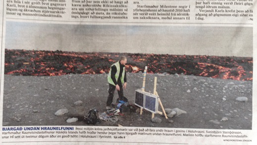
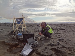
Picture: University of Cambridge seismometers were positioned so close to the dyke that when the eruption started the nearest instrument and its valuable data had to be rescued from advancing lava flows, making national news.
Professor Bob White’s volcano seismology group has operated a seismic network in the Icelandic Northern Volcanic Zone for over 10 years, in collaboration with Bryndís Brandsdóttir at the University of Iceland. This has presented many opportunities to study seismicity accompanying magmatic intrusions, such as the Upptyppingar and Eyjafjallajökull intrusions, and most recently the 2014 Bardarbunga-Holuhraun dyke and subsequent fissure eruption.
The seismometer network reached its maximum density and extent in 2014−15, with approximately 80 seismometers concentrated around the Askja volcanic system and the Vatnajökull ice cap, and stretching from the far east to the west of Iceland. Over the years, researchers in the group have built up a detailed picture of the crustal velocity structure and magma storage in the region, the causes and nature of both deep and shallow crustal seismicity, and seismicity accompanying dyke propagation.
Further information and reading
To find out more about the origins of seismicity in volcanic systems, visit the University of Cambridge volcano seismology group at the Royal Society Summer Science Exhibition 4-10 July 2016, where they will be showcasing their latest work on the Bárðarbunga-Holuhraun dyke intrusion and fissure eruption.
W: www.esc.cam.ac.uk/ExplosiveEarth. Twitter: @ExplosiveEarth; Facebook: www.facebook.com/ExplosiveEarth; YouTube: Cambridge Volcano Seismology www.youtube.com/c/CambridgeVolcanoSeismologyGroup
Watch the project's promotional video!
- Ágústsdóttir, T, Woods, J, Greenfield, T, Green, R G, White, R S, Winder, T, Brandsdóttir, B, Steinthórsson, S & Soosalu, H (2016). Strike-slip faulting during the 2014 Bárðarbunga-Holuhraun dike Intrusion, central Iceland. Geophysical Research Letters, plus Supplementary Information, 43, 1495‒1503, doi: 10.1002/2015GL067423
- Green, R G, Greenfield, T & White, R S (2015). Triggered earthquakes suppressed by an evolving stress shadow from a propagating dyke, Nature Geoscience, 8, 629‒632, doi: 10.1038/NGEO2491
- Greenfield, T & White, R S (2015). Building Icelandic igneous crust by repeated melt injections, Journal of Geophysical Research, doi: 10.1002/2015JB012009