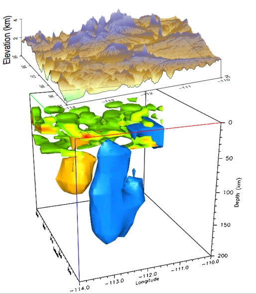
Picture caption: A convective "drip" of lithosphere (blue) below the Colorado Plateau is due to delamination caused by rising, partially molten material from the asthenosphere (gold), as plotted by Rice University researchers and their colleagues. (Credit Levander Lab/Rice University)
The Colorado Plateau – 130,000 square miles of Colorado, Utah, Arizona and New Mexico - is rising, and yet parts of the lithosphere below it are falling, reports Adler deWind.
Geoscientist 20.05 June 2011
The apparent thickening of the Colorado Plateau has puzzled geologists for some time, but is now explained in a paper published in Nature1. The research indicates that magmatic material is slowly rising, invading the lithosphere, and causing delamination, a process whereby lowermost layers peel away and sink, according to Prof. Alan Levander, (Rice University, Houston, Texas).
“The invading asthenosphere is two-faced. Deep in the upper mantle, between about 60 and 185 miles down, it's usually slightly less dense and much less viscous than the overlying mantle lithosphere of the tectonic plates; the plates there can move over its malleable surface” says Levander. “But when the asthenosphere finds a means to, it can invade the lithosphere and erode it from the bottom up. The partially molten material expands and cools as it flows upward. It infiltrates the stronger lithosphere, where it solidifies and makes the brittle crust and uppermost mantle heavy enough to break away and sink. The buoyant asthenosphere then fills the space left above, where it expands and lifts the plateau.”
Levander and co-authors have seen evidence for this process from data gathered by the massive USArray seismic observatory (hundreds of observatory-quality seismographs deployed 45 miles apart in a mobile array that covers a north/south strip of the United States). The seismic images (picture) revealed a pronounced anomaly extending from the crust well into the mantle.
Levander says the combined Colorado Plateau images show the convective "drip" of the lithosphere just north of the Grand Canyon. Here the lithosphere is slowly sinking several hundred kilometres into the Earth. That process may have helped create the canyon itself, as lifting of the plateau over the last six million years has defined the route of the Colorado River.
Levander said USArray has found similar downwellings in two other locations in the American West, suggesting that the forces deforming the lower crust and uppermost mantle are widespread. In both other locations, downwellings have happened within the past 10Ma. "Under the Colorado Plateau, we have caught it in the act" he says.
"We had to find a trigger to cause the lithosphere to become dense enough to fall off" Levander says. The partially molten asthenosphere is hot and somewhat buoyant, and if it finds a topographic gradient above it will flow - and undergo a small amount of decompression melting in the process. At this point it melts enough to infiltrate the base of the lithosphere and solidify.
Says Levander: “It is at such a depth that it freezes as a dense phase. The heat from the invading melts also reduces the viscosity of the mantle lithosphere, making it flow more readily. At some point, the base of the lithosphere exceeds the density of the asthenosphere underneath and starts to drip."
Reference
- Continuing Colorado plateau uplift by delamination-style convective lithospheric downwelling. A Levander, B Schmandt, M S Miller, K Liu, K E Karlstrom, R S Crow, C-T A Lee & E D Humphreys. Nature 472, pp461–465 (28 April 2011) DOI: 10.1038/nature10001