At 0818 on 28 April Folkestone and Kent were rocked by an earthquake that caused extensive damage. Alice Walker and Roger Musson* investigate…
The earthquake that shook Folkestone and the rest of Kent at 08:18 on 28 April, was by no means unusual for the UK as a whole, although the intensity of shaking and level of damage have rarely been exceeded in the few hundred years for which we have records.
At a magnitude of 4.2 ML, we experience this size of earthquake, or greater, every 5 years or so somewhere on land or in the UK offshore areas. The last one, onshore, which had a magnitude of 4.7 ML was centred near Dudley in the West Midlands in 2002. It caused some minor damage but not on the scale of the recent Folkestone earthquake where damage was locally heavy – to a degree seldom seen in the UK. In parts of Folkestone many houses suffered extensive damage to chimneys and walls. A small number of aftershocks, which were not felt, were recorded by the local seismograph station following the mainshock at Folkestone.
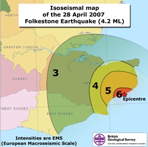
There is not a direct correlation between an earthquake’s magnitude, which is a measure of the energy released, and the intensity of shaking, which depends also on the distance to the epicentre, the depth at which the fault moved, and the surface geology. For Folkestone, initial results from the BGS’s online macroseismic survey, inviting the public to report the level of shaking experienced, indicates that most damage was close to the epicentre; confirmed by news reports and a field survey.
The epicentral location was determined using data from the BGS UK seismic monitoring network supplemented with French readings. The analysis places the focus of the earthquake 2km below the epicentre, in Folkestone. The maximum intensity is 7 EMS (European Macroseismic Scale), and the felt area extends throughout Kent and as far as Bognor, 130km to the west, and Norwich, 175km to the north, with a few unconfirmed reports at greater distances. It was felt weakly in Calais and Boulogne. The map shows contours for intensity 3, 4, 5 and 6 (EMS), with the highest intensity being too localised to be contoured.
Historically the people of Kent have felt earthquakes centred in, or near, the Dover Straits in 1950, 1776, 1580 and 1382; the two earliest ones had magnitudes estimated at just under 6, and caused damage as far as London, where in 1580 two people were killed by falling masonry. The last earthquake felt by residents in Folkestone was actually a Dutch earthquake (epicentre near Maastricht) in 1992. Comparisons can be made between the Folkestone event and the Colchester earthquake of 1884, magnitude 4.6 ML. At Colchester, there was also much damage in the epicentral region, and it is likely that similarities between Folkestone and Colchester will strengthen as more analysis is conducted; the shallow depth of both earthquakes and a ‘soft’ geological environment resulting in a concentration (and possibly amplification) of the ground-shaking in their epicentral areas.
Placing intraplate earthquakes such as the Folkestone event into a geological context is always difficult. Most British earthquakes are understood to occur as a result of reactivation of ancient structures in response to the current stress regime, which is dominated by Atlantic widening. While one may speculate that Dover Straits seismicity is associated with the western end of the North Artois Shear Zone, it is difficult to be certain about the seismotectonics of this area. Detailed study of the data from the Folkestone earthquake will, hopefully, shed more light on this difficult problem.
*British Geological Survey, Edinburgh