Penelope Wilson & Ken McCaffrey* report on digital mapping and analysis of the Maiden Creek satellite intrusion, Henry Mountains Utah
“… you can’t see anything from a car; you’ve got to get out of the goddamned contraption and walk, better yet crawl, on hands and knees, over the sandstone and through the thornbush and cactus. When traces of blood begin to mark your trail you’ll see something, maybe.”
 This quotation from Edward Abbey’s ‘Desert Solitaire’, arguably one of the best North American environmental narratives, epitomises fieldwork in south-west Utah. Here, to the newcomer, the endless procession of Chevys pulling speedboats along the long desert roads seems at odds with the wide and stark expanses of red rock, interspersed with the tie-dye patterned badlands, covered with only a smattering of the hardiest, most rugged vegetation.
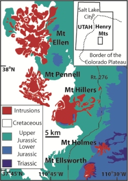
Map: Simplified geological map of the Henry Mountains region (adapted from Morgan et al., 2008)
Here, in the ‘Wild West’ and robber’s roost (infamous hideout of Butch Cassidy and his gang) the Henry Mountains rise up high into the blue sky from an intricate network of slot canyons, ravines and flats. Yet, despite their stunning and abrupt appearance on the skyline, few stop to even take a photo, let alone explore this beautiful yet harsh wilderness with bountiful exposures that would excite many a geologist. Instead they speed through the nearest town of Hanskville, picking up a burger from Blondies on the way to man-made Lake Powell.
GILBERT
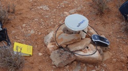 Picture: Roving survey DGPS (AshTech Pro 2)
It was during his studies in the Henry Mountains Utah that Grove Karl Gilbert (1877) first coined the term “laccolite”, and the region is now looked upon as one of the classic type localities for sill and laccolith intrusions. Since this early work, most studies of sill and laccolith intrusions have concentrated on their geometry and internal architecture, while only a few have paid particular attention to the emplacement-related host rock deformation structures, which preserve a record of how magma is accommodated within the crust, i.e. the intrusion ‘space problem’.
Our studies aim to develop a greater understanding of how igneous intrusive bodies are emplaced and accommodated within the shallow crust, using the classic exposures we find in the Henry Mountains as our field laboratory. In our research, traditional field mapping, outcrop studies and detailed data collection of deformation structures have been combined with digital mapping and terrestrial laser scanning (TLS), to enable 3D modelling of the intrusive bodies and emplacement-related host-rock deformation.
SETTING
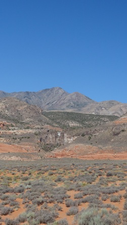
The Henry Mountains (pictured left) are located in south-east Utah, on the Colorado Plateau and were the last mountain range to be added to the map of the lower 48 states of the USA. Previously referred to as the ‘Unknown Mountains’, following his expedition of the Colorado River and its canyons, John Wesley Powell officially named the range in 1872 after the first secretary of the Smithsonian Institution. The range consists of five principal peaks reaching heights >3,000m (the elevation of the plateau ~1500m). From north to south these are Mt Ellen, Mt Pennell, Mt Hillers, Mt Holmes and Mt Ellsworth. Each peak signifies a distinct intrusive centre, emplaced into nearly flat-lying stratigraphy on a gently dipping eastern limb of an asymmetrical syncline. To the west of the Henrys lies the scenic Capitol Reef National Park, while to the east lie the Canyonlands. To the south stretches Lake Powell, while to the north you’re into the Badlands.
The intrusions are mid-Tertiary in age (31.2 to 23.3 Ma) emplaced within a ~2.7 km thick section of Palaeozoic sedimentary rocks overlying Precambrian crystalline basement. The intrusions all post-date minor Laramide orogenic activity in the area, emplaced during a period of tectonic quiescence. Therefore, all observed structures in the surrounding country rock may be attributed to the magmatic events. Likewise, fabrics within the intrusions largely reflect magmatic flow.
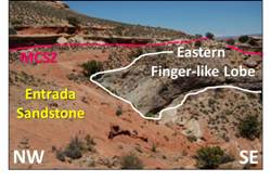
Maiden Creek, a satellite intrusion to the Mount Hillers intrusive complex, is a sill-like body with a complex elliptical shape with several finger-like lobes. During reconnaissance field mapping (summer 2011) across two neighbouring lobes, we discovered a sub-horizontal shear zone running along the top contact of each intrusive lobe. This shear zone separates low- to moderately-deformed sandstones above, from highly deformed sandstones below and between the two lobes, hence acting as a detachment zone.
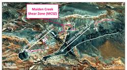 Pictures: Google™Earth (left) and outcrop (right) views of southern finger-like intrusive lobes and Maiden Creek Shear Zone (MCSZ; pink).
 Strain within the highly deformed sandstones is dominated by compressional faults, fractures and fabrics which point to a ‘bulldozing’ mechanism for lobe emplacement. Fabrics (stretched plagioclase phenocrysts) within the igneous rock, seen on the upper surface of the intrusive lobes directly beneath this shear zone, show that the shear zone was contemporaneous with magma emplacement. The shear zone therefore appears to have played a critical role in accommodating magma emplacement.
A 3D-MODEL
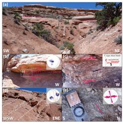
Images: (a) Sandstone gully between the southern-pair of finger-like lobes; note MCSZ separating low- to moderately-deformed sandstones above from highly deformed sandstones beneath. (b) MCSZ in outcrop. (c) C-type shear banding shows top to the west and up-dip movement. (d) Monoclinal folding and kink-band style deformation corridors adjacent to the lateral margin of the finger-like lobes. (e) Mineral lineations (stretched feldspars) on the top surface of the finger-like lobes, directly beneath the MCSZ, note E-W trend, consistent with MCSZ kinematics.
Due to the structural complexity within the Maiden Creek Shear Zone study area, it is very difficult to capture the 3D geometry and spatial distribution of the geological framework and deformation using conventional mapping methods. Therefore, Terrestrial laser scanning (TLS) was carried out during a second field season (summer 2012; enabled through funding received from the Geological Society of London) with the aim of acquiring both regional (360⁰ panorama) and high resolution laser scans. The full extent of the shear zone has been captured using TLS, while the scans have also helped to capture fracture and bedding geometries from inaccessible outcrops. Laser scan data provide unprecedented detail and allow spatial variation of fracture attributes to be quantified (e.g. fracture geometry, connectivity, deformation band aperture, and spatial correlation between fracture density and fold curvature relative to intrusion).
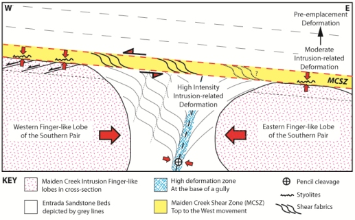 Image: Summary cartoon highlighting key geological field observations relating to the MCSZ study area.
If ever the words of Edward Abbey rang more true during our field work, it was while carrying out the laser scanning - precariously balancing £80,000-worth of equipment as close to the cliff edge as we dared, to get the best view into the gullies. Not forgetting the (too many to count) scratches acquired when carrying (or towards the end of each field day, dragging) the boxed laser scanner and all its accessories from vehicle to outcrop, while trying to find a meandering path through the sharp sagebrush, shrubbery and prickly pears, in sweltering 40⁰C heat. Clothes were torn and blood was shed. Much time was spent cloud-spotting, looking to the sky, tracking the paths of tiny clouds in hope that they would cover the sun at just the right time, and for long enough, to give us the best images (unlike conventional photography, cloud cover is a plus in TLS, as it increases colour contrasts when the scanner is capturing photos). But with clouds come thunderstorms and the flash floods, and as the sky grew angry on our final day of scanning, the 4x4 showed its worth - safely transporting us off Maiden Creek and the quickly collapsing dirt road back to the tiny haven of Hanksville.
FURTHER WORK
The laser scan data are currently being interpreted to create a 3D geological framework model of our emplacement-related deformation structures. This shall then be integrated with the structural and kinematic data collected by conventional means in order to build a geomechanical framework model. This, combined with parallel studies looking at the internal architecture of these intrusions, shall hopefully enable us to be more predictive about high-level magma emplacement mechanisms and associated deformation.
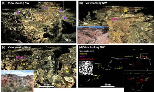 Images: (a) Screen capture of RiSCAN PRO™ project of laser scan point cloud data across the MCSZ study area. (b) Zoom in of structurally complex zone where MCSZ separates low-/moderately-deformed sandstones above from highly deformed sandstones below and between two igneous lobes, area highlighted in (a). See inset photo for comparison. (c) Zoom in of folded sandstone units around irregular lateral margin of igneous lobe, area highlighted in (a). (d) Active interpretation of laser scan point cloud data (same view as (a)). Inset shows zoom-in to highlight fracture picking. QR code provides a link to a fly through animation of the laser scan model (also available at the following site: http://studentnet.kingston.ac.uk/~K0635100/video/).
Acknowledgements
Fieldwork was funded by the Geological Society’s Elspeth Matthews Fund. Further thanks go to Midland Valley for the provision of Move™ software.
The Society’s research grants 2014 will open for application in November 2013, when an announcement will be made in these pages. See www.geolsoc.org.uk/grants .
* School of Geography, Geology and the Environment/ Centre for Earth and Environmental Science Research (CEESR), Faculty of Science, Engineering and Computing, Kingston University London; Director, Centre for Research into Earth Energy Systems (CeREES), Department of Earth Sciences, Durham University.
Further reading
- Abbey, E 1968. Desert Solitaire A season in the wilderness Ballantine Books, 337 pp
- Gilbert, G K 1877. Geology of the Henry Mountains, Utah US Geographical and Geological Survey of the Rocky Mountain Region, 170 pp
- Horsman, E , Tikoff, B and Morgan, S 2005. Emplacement-related fabric and multiple sheets in the Maiden Creek sill, Henry Mountains, Utah, USA Journal of Structural Geology, v 26, pp 1426-1444
- Jackson, M D and Pollard, D D 1988. The laccolith-stock controversy: new results from the southern Henry Mountains, Utah Geological Society of America Bulletin, v 100, pp 117-139
- Hunt, C B 1988 Geology of the Henry Mountains, Utah, as recorded in the notebooks of G K Gilbert, 1875-76 Geological Society of America Memoir 167, 229 pp
- Morgan, S , Stanik, A , Horsman, E , Tikoff, B , Saint-Blanquat (de), M and Habert, G 2008. Emplacement of multiple magma sheets and wall rock deformation: Trachyte Mesa intrusion, Henry Mountains, Utah Journal of Structural Geology, v 30, pp 491-512
- Nelson, S T , Davidson, J P and Sullivan, K R 1992. New age determinations of central Colorado Plateau laccoliths, Utah: Recognizing disturbed K–Ar systematics and re-evaluating tectonomagmatic relationships Geological Society of America Bulletin, v 104, pp 1547-1560