Product has been added to the basket

Into the abyss

Geoscientist 17.7 July 2007


In the third of our Bicentenary surveys of 19th and 20th Century Earth science, Sue Bowler* reports on the emergence of oceanography as a discipline. 


Much of the impetus for and testing of the plate tectonics hypothesis came from the emerging geological view of the oceans from systematic mapping in the 1950s and 1960s, in turn arising from wartime and defence technology. The picture of the ocean floors that emerged was riveting: undersea mountain ranges built by volcanoes and shaped by tectonics, segmented by transform faults to match the curvature of the Earth. And, in the 1970s, came the discovery of whole new ecosystems on the seafloor, where hydrothermal vents deposited minerals in immense mounds and towers, colonised by new forms of life, thriving out of reach of the Sun.

The exploration of the oceans was – and continues to be – a technological tour de force. From the depth, temperature and currents surveys of the Challenger Expedition in the nineteenth century (see Box) to today’s remote sensing, robot submarines and submersibles, geoscientists have developed tools to uncover this hidden 70% of the Earth’s surface. The 1950s and 1960s maps of the seafloor1 synthesised the limited data available into a compelling picture of mysterious mid-ocean mountain chains, which spurred further exploration. Remote sensing became the principal tool for mapping the seafloor, with refinements such as sidescan sonar to illuminate the slopes and scarps of the plate boundary in great detail, especially when submersible instruments such as the UK’s TOBI (Towed Ocean Bottom Instrument) were used to get closer to the ocean floor.

Bruce C Heezen, Marie Tharp, Maurice Ewing 1959:The floors of the Oceans Things hotted up in 1977 with the discovery of hydrothermal vents, where hot, mineral-rich water gushes from the seafloor. Researchers exploring the Galapagos Ridge in the Pacific Ocean in the deep-diving submersible Alvin saw mineral mounds, with hot water flowing out – and the strange creatures living aroudn the vents through Alvin’s tiny portholes. This US machine, built in the 1960s for deep diving exploration, took a pilot and two researchers to the ocean floor to sample rocks, sediments and water2. Subsequent dives found more hydrothermal vents, some spouting black mineral-laden water from chimneys of minerals, and a fair few in which the water emerging from the ocean floor was hot enough to melt Alvin’s thermometers.

Whilst oceanography had always been a multidisciplinary pursuit, the flurry of exploration and research that followed the discovery of hydrothermal vents made collaboration a necessity. How, and how far, did water circulate within the seafloor? How did the plumes from black smokers interact with ocean currents? How were new vents colonised? How did the vent creatures live there? Could vent processes build ore deposits? Above all, how do you collect enough data about these remote sites to answer such questions? International interdisciplinary collaborations, to devise and build new instruments as well as carry out the research, has provided some answers – and provoked a lot more questions in this lively research field.

Black Smoker. This jet of hot mineral-laden water from the Atlantic seafloor has built its own chimney (P. Rona OAR/National Undersea Research Program (NURP); NOAA). In the 1990s UK researchers, led initially by Joe Cann and Roger Searle, established BRIDGE, the British Mid-Ocean Ridge Initiative3, a national collaboration to explore the Mid Atlantic Ridge (MAR). Through BRIDGE and its dedicated funding through the NERC, UK researchers developed and deployed new instruments, and set up sesimic and other investigations in key areas along the MAR, in order to describe and understand how the Mid Atlantic Ridge worked. BRIDGE researchers were also part of international collaborations, for example in submersibles and as part of the Ocean Drilling Program. They investigated the pattern of volcanism and tectonics that shaped the undersea landscape on the ridge4 and integrated heatflow, gravity and seismic surveys to focus on the plume – or lack of it5,6 – beneath Iceland.

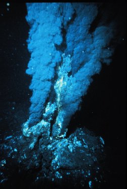
Measurements of localised and diffuse fluid flow at the vents revealed the contribution of vent flows to the chemical budget of the oceans7, for example, linking ocean fluxes with atmospheric and climate science8. The discovery that shrimps, mussels and tubeworms thrive at vents thanks to symbiotic bacteria that feed on hydrogen sulphide boosted research on microorganisms that can survive in such extreme environments. Extremophiles, microbes that live at extremes of heat, pH or aridity, are now thought to be the most likely forms of life to be found elsewhere in the solar system and astrobiologists and astrogeologists are devising ways to search for them on Mars, Europa and beyond. These researchers face the same sort of problems that oceanographers tackle: the field area is inhospitable and difficult and expensive to reach; the targets are tiny and rare. Solutions, too, have common threads: robust instruments, clever remote sensing and multidisciplinary research teams.

UK geoscientists now take their place with researchers of varied disciplines to work on the oceans. Much UK expertise is concentrated at the National Oceanography Centre, Southampton, which brings together research and teaching in the relevant disciplines. NOCS manages the national research fleet, including the recently launched RRS James Cook (Geoscientist 17, 4 p4) and has developed robot submersibles to explore new ocean areas, most recently sending the submersible Isis to the seafloor in Antarctica. These approaches, combined with data from increasing numbers of Earth observation satellites such as ESA’s Envisat, is bringing the pattern that Wyville Thomson began to discern in the nineteenth century into sharper focus and allowing the newly-discovered cycles of the ocean basins to take their place in the greater cycles of ocean chemistry and circulation.

A modern view looking north along the Reykjanes Ridge near Iceland, showing ridges running at an angle across the rift valley – signs of the interaction between magma and tectonics that builds the ridge.
Dredging and sounding on board the Challenger

The Challenger Expedition: the first oceanographic cruise

Modern oceanography began with the voyage of HMS Challenger from 1872–1876. Over more than 3 years, sailors under the command of Captain (later Sir) George Strong Nares and scientists led by Charles Wyville Thomson, Professor of Natural History at the University of Edinburgh, explored the oceans, taking depth soundings, temperature readings and dredging the ocean floor where they could. They collected many thousands of samples of seafloor sediment, rocks, water and undersea life – including 4000 new species – and discovered the underwater mountains at the centre of the Atlantic Ocean. They were the first to collect systematic data on currents and temperatures on such a large scale, and set a record for deep dredging at 7.6km, at the edge of the Japan Trench.

Many of the features that have marked oceanography in later years were there 130 years ago: international and cross-disciplinary collaboration, use of Navy vessels, with military interests in part driving research goals, specialist, not to say arcane, equipment, a driven and charismatic leader and a substantial publication at the end of it all: the Report on the Scientific Results of the Voyage of HMS Challenger (1880–95).

References cited:

  1. Bruce C Heezen, Marie Tharp, Maurice Ewing 1959:The floors of the Oceans
  2. The North Atlantic Geol Soc America Special Paper 65
  3. Water Baby Victoria A Kaharl OUP 1990 http://www.soton.ac.uk/~jtc/fierydeep.html
  4. Smith, D K and J R Cann, Building the crust at the Mid-Atlantic Ridge, Nature, 365, 707–715, 1993
  5. Searle, R C , et al. 1998: The Reykjanes Ridge: structure and tectonics of a hot-spot influenced, slow-spreading ridge, from multibeam bathymetric, gravity and magnetic investigations Earth and Planetary Science Letters, 160, 463-478 Abstract
  6. Foulger, G R and D L Anderson, A cool model for the Iceland hotspot J. Volc. Geotherm. Res., 141, 1-22, 2005
  7. A Schultz, H Elderfield: Controls on the physics and chemistry of seafloor hydrothermal circulation Philosophical Transactions of the Royal Society A: 355(1723) 387–425
  8. http://www.ipcc.ch/


    * Dr Sue Bowler is a Contributing Editor of Geoscientist.