Product has been added to the basket

Diamond rivers


Namibia's often cruel coastline also conceals bounty

Placer diamonds are so intertwined with southern Africa's geological evolution that in discovering their controls scientists must continually question the post - Carboniferous geology of the whole sub-continent, report Brian J Bluck# and John D Ward*.


Geoscientist 18.01 January 2008


Southern Africa has the largest and most valuable placer diamond deposits in the world, all strung out along its western coast. The development of this deposit is intricately involved with the evolution of not only the interior, but also the coastline itself. The Kaapvaal carton, along with parts of the Indian subcontinent and the Pilbara craton in Australia, is also one of the oldest Archaean continental cores in the world – the Ur continental segregation. It is however, in contrast to the rest of Ur, the world’s highest cratonic plateau, reaching more than 1.5km above sea level.

The principal source of the diamonds are the many kimberlites that intrude the old Archaean crust and which have then been eroded by the Vaal and Orange Rivers, taken to the coast and then separated from the accompanying sediment into rich placer deposits. The Orange River is quite unusual in this respect: it is has a large drainage basin and yet at its mouth it carries boulder-sized clasts to the sea - mainly derived from a mountainous coastal fringe. It also uniquely drains a high percentage of the Kaapvaal craton - far more than is the case with other large rivers, like the Congo or the Lena, which also cut through the Archaean crust. In addition, as the climate of southern Africa has been semi-arid–arid for some time, the river does not carry a high sediment load. It rises in the Drakensberg-Maloti Mountains, where the rainfall is >1.5.m/yr. It then traverses a major, high, largely featureless craton, where the climate is arid and is likely to have been mainly arid for the greater part of the last 50 million years.

We know that kimberlites - principal source of the diamonds - have been intruding the Kaapvaal craton since c. 3.0 Ga because diamonds have been discovered in conglomerates from Witswatersrand deposits (themselves dated at 2.97 Ga). However major periods of intrusion are roughly 1500, 1000, 250, 200, 150-250, 100-150 and 50-100 Ma. Diamonds occur mainly in the upper levels of the intrusion and are the first to be eroded. So the youngest pipes therefore have the greater chance of providing the greatest abundance of diamonds. Kimberlite is quite a soft rock that breaks down easily and generally leaves a depression on the surface (rather than a prominence, as is the case with most intrusive rocks). It often has a tuff-ring, and after intrusion, sediments from this ring are partly gathered back into the hole left by the kimberlite - adding to its diamond potential.

The Orange and the Vaal Rivers (the later dubbed the River of Diamonds by Helgren (1979)) have a total drainage area of c.1 million km2 and have a history stretching at least as far back as the Cretaceous. Offshore from the present mouth of the Orange River, seismic sections have demonstrated a large deltaic sediment mass, which has built the continental shelf outwards towards the west. These sediments are c. 103 to 65 million years old and indicate a major sediment outfall at the Orange River mouth at that time. The sediments are mainly sand-grade and finer and the whole pile is skewed to the north - suggesting that a northward drift was already established at time of deposition. Some of the sediment comprises northward-directed aeolian dunes and associated coastal sediments and some, probably delta plain deposits, being made up of a great thickness of sandstone.

Namibian diamonds After a major, regionally extensive unconformity near the base of the Cenozoic, the next set of known dated strata seen along the coast derive from the Mid Eocene (c.43 Ma). These are mainly shoreface sediments containing clasts of agates, chalcedony and jasper and thought to have a provenance partly in the Vaal River. Some clasts reach 100mm is size. Clasts in deposits with a very similar composition near to the Orange River's mouth can be 500-600mm in size. Between the formation of the Upper Cretaceous delta and the Eocene there appears to have been a dramatic change in the Orange River system, from fairly mature drainage to an incising regime accompanied by a westward tilt. At this juncture, the Orange River first began to deliver diamonds to the coast and to deposit them in the terraces along its channel.

This uplift of a pre-existing river system began a phase of erosion, which removed the soft Carboniferous -Triassic sediments that had been accumulating on the craton (in the foreland basin to the Cape Fold Belt).

The rivers would have begun an incision into the basement rocks including the craton itself and the fold belts that had wrapped around it. The kimberlite pipes intruded into these deposits would have yielded a great number of diamonds to the river, not only from the surface, but also from deeper within the pipes.

In spite of its diminishing water supply, in places the river maintains a meander loop-size inconsistent with its current flow, and consistent with a much larger river - as is often seen in cases of superimposed drainage. The meander loops reach c. 6-10km and are c. 5-7km near the coastal plain where the river has cut quite deeply into the basement rocks of the pan-African fold belt. Some smaller tributary rivers have smaller meander loops and these again are deeply incised through a Karoo cover and into the pan-African basement (Fig.2). Indeed, the loop size of the Orange River is consistent with a channel having a drainage of (very roughly) 1 million km2 as does the present Orange today. It seems likely that the Orange river and some of its tributaries were incised during Early Cenozoic uplift and have retained a partial "memory" of its former Cretaceous scale.
Namib diamonds

Diamond delivery

The delivery of diamonds to the coast is a complex affair, but the process is a beneficial one to the overall quality of the deposit. Few gem quality stones can be found among diamonds in pipes (c. 25-50%). But as these are transported, even over short distances, they tend to break down – thus increasing the concentration of higher quality stones. After >1000 km of transport, over rough ground where the river is incising into bed rock, that process results in an extremely high-grade, gem-quality, deposit. In the marine environment this process continues until only gem-quality deposits remain.

The history of the distribution of diamonds down the river is partly recorded in the terraces. These are grouped into three: a "pre-Proto" terrace which is among the highest ; a "Proto" terrace dated at c.20 -17 Ma, and a "Meso" terrace, which is c. 3 Ma old. The amount and grain-size of the diamonds vary according to the terraces in which they are found, and for each terrace the diamond size declines downstream. For the coastal reaches of the Orange River diamonds in the pre-Proto are c.30 cpht (carats/hundred metric tons) and a stone (diamond) size of c.1 carat / stone. Diamonds are less abundant in the Proto (c. 5 cpht and a larger stone size of c. 1-2 carats/stone). The Meso terraces have a very small number of diamonds (c. 0.5-0.2.cpht) but a very large stone size of c. 3 carats /stone. This implies that the maximum flood of diamonds came down the river either c. 20 Ma or before that time, and that the stone size was not particularly high but increased with time.

It would appear that the Orange River (or its former channel) first easily took off the soft foreland basin sediment and dumped it into the Cretaceous delta. The c. 90 Ma kimberlites were intruded and diamonds from them gathered in the headwaters of the Orange-Vaal Rivers and were then brought down as an original flush at possibly c. 25-40 Ma. Subsequently they became less abundant, but coarser, with time.

Namibian diamonds The coastal strip, extending northwards from the Orange River mouth to >1000km north, contains diamonds that generally decrease in grain-size to the north. Another trail of diamonds, also decreasing in size to the north, is found along the South African coast - beginning roughly at the mouth of the Oliphants River and ending roughly at (or South of) the Orange River mouth - a distance of c. 350 km.

It is difficult to escape the conclusion that there are two dispersal systems along this coast: the Orange River, and probably the Oliphants River or its precursor. The Oliphants River would have been a far earlier drainage than the Orange, and would have built a diamond deposit that was subjected to a range of sea-level changes far greater than those of the Orange River coastal deposits. Deposits from the Oliphants River are probably recorded in the offshore seismic sections at c.119 Ma.

In post Cretaceous time the inner shelf from the Cape of Good Hope to the St. Francis Bay in the north was neutrally buoyant. There is very little post-Cretaceous sediment on this part of the shelf and it would appear that the Orange River sediment was effectively dispersed according to grain size, with the coarse sediments (from the Pan-African and associated formations) being plastered along the coast. Sand moved then along the coast by longshore drift and was then blown back onshore to form the Namib Sand Sea while the more fine-grained sediment was transported along the coast and out eastward, to build the continental shelf edge (Fig. 3b ). In this sense the Orange displays a peculiar kind of delta, with the sand fraction returning to land and the mud being almost entirely removed.

A number of factors are needed to achieve this kind of sediment dispersal. First, it requires a shelf that does not subside greatly, to allow the build-up of sediment. Second, it requires a very high-energy system along the coast, capable of separating the sediment and transporting it away from the point of original discharge. Wave-heights in the region average c. 1.75m (winter) and 1.5m (summer) and have a particularly long wavelength. This means they are able to scour the shelf to some depth. Third, it requires an arid or semi-arid coastline that may have existed for as long as c.50 Ma.

Many of the diamonds move with the gravel and are separated further when they meet the wave-cut platform. These platforms, repeatedly cut by the fluctuating sea-level, are often extremely rough and it is this roughness that allows populations of diamonds to form within them. A very high percentage of the coastal diamonds are therefore trapped in the rough bedrock, but the overlying beaches also trap diamonds. Platform roughness varies along the coast according to the nature of the bedrock. Beach characteristics also vary along the coast from south to north - spits in the south decrease to the north, where they are replaced by barrier and linear beaches, and finally by pocket beaches. These beaches, which are Pliocene to Recent in age, were very clearly laid down some 20-40 Ma after the main flux of diamonds came down the river. They acquired their diamonds not directly from the Orange but from the reworking of former deposits in the offshore.

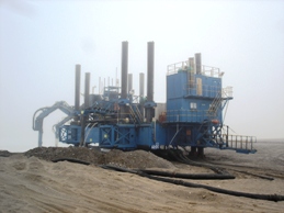
While land extraction of diamonds is almost complete, both inshore and offshore clearly have enormous potential.

The conditions that successfully separated the grain sizes of the Orange River sediment and concentrated the diamonds are also providing workers inshore with great difficulties in their recovery work. Wave energy on that coast is so high that although it separates the diamonds from the sand it also provides the diggers with enormous practical obstacles. Diving has proved too hazardous and the miners are now working a on a legged platform that 'walks' out to sea sucking up the sediment. Small scale trials using this method have had moderate success.

Further reading

  1. Corbet. A. 2002. Diamond beaches. A history of Oranjemund. Namdeb Diamond Corporation, Windhoek
  2. Helgren, D.M.1979. Rivers of diamonds: An Alluvial History of the Lower Vaal Basin, South Africa University of Chicago, Department of Geography, Research Paper, 185, 389p
  3. Mc Carthy,T. & Rubidge, B. 2005. The story of earth and life A southern African perspective on a 4.6-billion year journey. Kumba Resources, Cape Town

Figures


Editor's note:  Geoscientist regrets that for technical reasons it has not been possible to supply the figures that accompany the print version of this piece.  Here are the captions to those figures.  Ted Nield


  • Figure 1. The distribution of kimberlites, together with some of their ages, and placer deposits on the Kaapvaal craton. The disposition of the Orange River drainage basin in relation to the Kaapvaal craton.
  • Figure 2 Showing the relationship between meander wave length and drainage basin area. Solid dots are data collected from the world and open circle are data collected from the Orange River basin.
  • Figure 3 a. Index map for Figure b. Figure b, showing the coastal deposits, dunes and the paths of dispersal of the sediment. C, the grain size decrease in diamonds northwards along the coast beginning at the Orange River mouth. d. The changing size and grade of diamonds averages for the coastal reach of the Orange River terraces. Solid line = grade; dotted line = stone size

Pictures

All pictures kindly supplied by Dr Gabi Schneider, Director, Geological Survey of Namibia.

# University of Glasgow
* GEM Diamonds Technical Services, Johannesburg.