Fancy climbing Africa’s highest peak? Roger Scoon* tempts you with the geology of Kilimanjaro
 The huge bulk of Kilimanjaro, one of the world’s largest free-standing mountains, is located some 80km east of the Gregory Rift Valley in an area of northern Tanzania characterised by giant free-standing volcanoes. The massif comprises three discrete volcanic centres covering an area 80x48km and towering more than 5000m above the regional plateau.
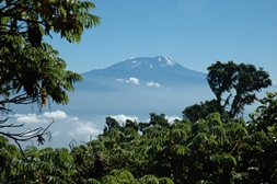
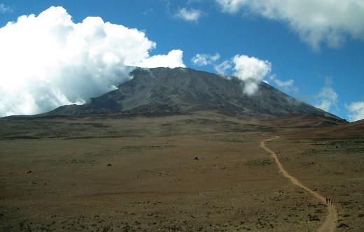
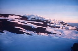
Picture: Western slopes of Kibo from Mount Meru with Uhuru Peak on the caldera rim and southern icefield (right) and northern icefield (left) (2004).
The lowest peaks, Shira (4006m) and Mawenzi (5149m) are eroded remnants of extinct cones, whereas the highest peak, Kibo (5895m) is capped by a summit plateau with an active crater. The vegetation zones that characterise many of the East African volcanoes are well developed on Kilimanjaro: they include extensive montane forests, an Alpine heath zone, as well as small glaciers and icefields.
Discovery
 Reports in 1848 by Johannes Rebmann of an ice-capped peak near the Equator were treated with scepticism in Europe, despite references to an African ‘Moon Mountain’ (possibly the Ruwenzori) in classical literature. Both the Greek geographer Strabo and the Roman mathematician Ptolemy are thought to have based their descriptions on information from Ancient Egypt.
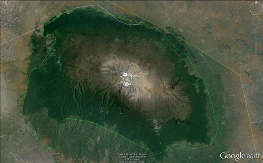
Picture: Google Earth image of Kilimanjaro showing the outline of the National Park and the extensiveness of the montane forest (dark green).
The first ascents of Kibo were made by Hans Meyer, who reached the summit plateau via the southern icefields in 1887, and then Uhuru Peak in 1889. Most of the volcano is incorporated into the Kilimanjaro National Park, which is also a World Heritage Site. The park is a major contributor of foreign earnings to Tanzania, and is visited by large numbers every year. The mountain is usually approached from the southern side by the regional town of Moshi (altitude 854m), but views from the northern (Kenya) side are equally spectacular.
Geological setting
Kilimanjaro was mapped in remarkable detail during the 1953 and 1957 expeditions by the University of Sheffield and Geological Survey of Tanganyika. An early report by Wilcockson (1956) was followed by a detailed study by Downie and Wilkinson (1972), upon which the following description is largely based.
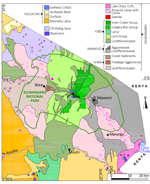 Map: Geological map of Kilimanjaro simplified from Downey and Wilkinson (1972). The Small-rhomb Porphyry Group is included with the Lent Group.
Kilimanjaro occurs in a 100km-long faulted belt of intense volcanism that strikes almost at right angles to the Gregory Rift. The Neoproterozoic-age Mozambique Belt crops out near Moshi, but most volcanoes in this area are constructed on an older volcanic terrane. These include the Molog basalts to the northwest of Kibo. Kilimanjaro occurs where a NW-SE striking fault has intersected a lineament aligned at 080o.
Volcanic centres
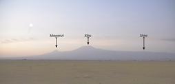
Volcanism associated with Kilimanjaro covers an area of 6000km2. This is larger than the mountain’s topographic expression, as lavas extend out onto the adjacent plateau. The three centres Shira (west), Kibo (centre), and Mawenzi (east) are aligned, some 30km apart, on an axis striking at 1100.
Shira (2.5-1.9 Ma) is part of the older (Pliocene-Upper Pleistocene) volcanism. Mawenzi (1.0-0.45 Ma) and Kibo (0.48-0.15 Ma) are part of the younger volcanism of this area. A total volume of 4790km3 was erupted: including 500km3 from each of Shira and Mawenzi and 3790km3 from Kibo. The dominant flow directions for the three centres are southwest (Shira), east (Mawenzi) and north, south and west (Kibo).
Parts of Shira and Mawenzi are obscured by the younger Kibo volcanism, and for this reason (as well as the technical difficulty of ascending Kibo) the older cones are poorly known. The younger group of parasitic cones and localised flows shown on the map is probably part of the Kibo volcanism.
Kilimanjaro volcanism is dominated by lava with minor tephra. Shira and Mawenzi produced mostly basalt and trachybasalt. Kibo displays a differentiation trend of increasingly silica-undersaturated lavas: trachyandesite gives way initially to phonolite and then to nephelinite. Lahars (probably debris avalanche deposits or DADs) are associated with Mawenzi (an area of 1000km2 within Kenya – not shown on the map) and Kibo, the latter occurring on the southern slopes.
Shira is located on the broad, western shoulder of Kibo, its highest point being the western rim of an eroded crater. The northern and eastern parts of the crater are covered by lava flows associated with Kibo. Plazkegel is a prominent cone-shaped hill rising some 240m from the crater floor a few kilometres east of the ridge. The cone is an agglomerate plug and is associated with a radial dyke swarm. The crater is partly filled with younger sediments.
The precipitous cone of Mawenzi is capped by a horseshoe-shaped ridge - remnants of an eroded crater. The summit ridge on the western and southern sides is precipitous, with near-vertical outer cliffs. Steep ravines on the outer slopes include two large features known as the Greater and Lesser Barrancos. They are associated with collapse of the crater wall on the eastern side - the event that triggered the lahar. Two main vents have been identified: Mawenzi and Neumann Tower (located 2km east of the summit). A number of intrusive gabbroic plugs occur. The ribbed appearance of the main cone is ascribed to erosion of a swarm of 600-800 radial and concentric dykes.
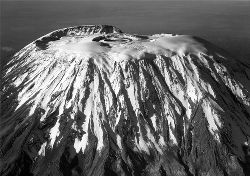
Picture: The gentle shoulders and immense size of the Kilimanjaro massif viewed from Amboseli, Kenya.
The uppermost part of Kibo – which resembles an upturned basin – is an eroded caldera, sitting some 4500 m above the broad outer shoulders of the massif (pictures). The steepness of the upper slopes is related to caldera collapse, which occurred at around 0.17 Ma. The interior walls of the caldera rise some 180m above an elliptical summit plateau measuring 2.7x1.9km.
The Marangu Route attains the plateau at Gillman’s Point. The caldera is tilted southward so that Uhuru Peak is located on the southern rim of the caldera rather than on the inner cone. A scarp associated with the caldera fault has been mapped on the southern and western sides of the summit plateau. The Kibo lahar was triggered by caldera collapse and carved the Barranco - a deep gorge with high cliffs located on the outer western slopes - prior to spreading onto the southern slopes.
The caldera rim overlooks the inner (and younger) features of the summit plateau. Many older lava flows on Kibo (only exposed on the lower south-western slopes) are covered by younger flows that originated near the summit. Ten groups of lavas have been identified, many separated by cycles of erosion. The youngest flows are intercalated with glacial deposits (see below).
 Picture: Saddle on the Marangu Route looking towards the outer walls of the Kibo Caldera
Older lavas are grouped together for simplicity on the map. They include trachyandesite with a distinctive porphyritic texture (0.48 Ma). The distribution of the Lent and Small-rhomb Porphyry (0.36-0.38 Ma), Caldera Rim (0.23-0.17 Ma), and Inner Crater (0.15 Ma) groups are shown, dominated by trachyte and phonolite. A body of syenite related to the Small-rhomb Porphyry Group and c. 150m thick has intruded the outer rim of the caldera in the Barranco.
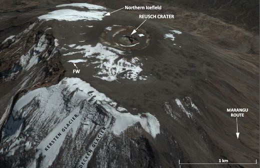
Reusch Crater (diameter 820m) is located asymmetrically in the north-eastern part of the summit plateau. The crater is rimmed by walls of the Inner Cone that are severely eroded (the altitude is 60m lower than Uhuru Peak). The Ash Cone with its central vent, the Ash Pit, occurs within the crater. The Ash Pit is 340m in diameter and 130m deep. The inner slopes become vertical with depth.
This, the youngest volcanic feature on Kibo, may have hosted a lava lake that withdrew so rapidly as to preserve the conduit. Active sulphur-rich fumaroles (recording temperatures of 77-1040C) and steam vents occur on the fractured western wall and ‘terrace’. A deposit of 6-7000 tonnes of sulphur occurs in the crater, forming a 0.15m-thick crust. The Inner Crater group includes a nepheline-bearing phonolite (within the crater) and a flow of nephelinite that has overflowed the caldera and extends down the north-eastern slopes. The caldera fault scarp reveals beds of agglomerate and cinder.
About 250 parasitic cones occur on the lower and intermediate slopes of Kilimanjaro. Dated at between 0.20 and 0.15 Ma, they may be contemporaneous with the Reusch Crater and are associated with Stombolian-type activity that formed cones of cinder and ashes 60-100m in height. They reveal a broad compositional range (picrobasalt, trachybasalt, ankaramite, and basanite). Lake Chala on the Kenyan border fills a crater from which an extensive calcareous tuff has been ejected. These eruptions are thought to have destroyed a settlement several hundreds of years ago, providing the most recent evidence of volcanic activity on Kilimanjaro.
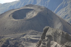 The giant stratovolcano of Mount Meru (4560 m) which is located some 50km to the south-west of Kilimanjaro may exhibit some reciprocity between the two centres. The ash cone within the huge caldera (picture) is an active component of a volcano that may be hazardous to the nearby town of Arusha.
The Momella Lahar – one of the world’s largest DADs, and associated with the partial collapse of Mount Meru around 8000 BP - spread onto the south-western slopes of Kilimanjaro.
Picture, right: The ash cone at Mount Meru is situated in a huge caldera (2004).
Ice fields
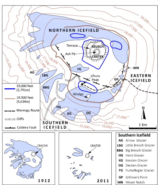 Map: Summit plateau, Kibo, based on Mitchell (1971) with distribution of icefields in 1912 and 2011 from Hardy (2011). The outer rim of the caldera correlates approximately with the 18,500 foot contour.
Ice distribution has changed repeatedly since the Pleistocene. The half dozen or so early glaciations (680,000-130,000 BP) and the Main Ice Age (110,000-12,000 BP) gave rise to extensive ice sheets. During the Last Glacial Maximum (20,000 BP) the massif was covered by a 400km2 ice cap.
Mapping glacial deposits and moraines intercalated with lava flows has enabled four older glaciations to be identified on Kibo. Moraines are typically some 5m thick and 6km long, and are well-developed in valleys on the southern slopes at elevations of 3350-3960m, where they were deposited by the Southern glaciers. Smaller moraines are associated with ice movements during the Little Ice Age and Mini-Ice Age. Extensive moraines occur in the radial valleys on Mawenzi.
Ice cores
Ice cores drilled into the Northern Icefield of Kibo reveal that the ice has a maximum age of only 11,700 BP, and ice disappeared entirely around 12,000 BP during an extremely dry period. Slope glaciers have occurred on Kibo throughout the last 10,000 years, but the summit icefield appeared and disappeared repeatedly, probably again due to dry cycles.
These cores are an important record of climate change in Africa. Slope glaciers have occurred throughout the last 10,000 years, but the summit icefield has appeared and disappeared repeatedly. The latter is generally ascribed to dry cycles occurring every few hundred years due to precession of the Earth’s orbit.
The African Humid Period (11,000-4500 BP) is recognised as a time when ice sheets and glaciers expanded considerably. During this period, lakes in the Gregory Rift deepened by as much as 100m. Evidence from variations in the Na and F content of the aerosol (important components of alkaline lakes) indicates an anomalously dry period at 8300 BP. (The timing of the catastrophic eruption at Meru is a coincidence that has never been recognised.) A second dry period, which caused recession of the ice at 4000-3700 BP, is known as the First Dark Age. This was so widespread as to have affected civilisations around the Nile River and in the Middle East.
Recession
 Early reports described Kibo as covered by a large icecap and the first ascent via the Hans Meyer Notch was made when the summit plateau was almost entirely ice-covered. Only the Reusch Crater was ice-free. This “historical” icecap covered an area of 20km2 with slope glaciers extending to altitudes of 4500 m. An aerial photograph taken in 1938 revealed the icecap to have shrunk to 11.4km2. A map of the summit plateau (published by Mitchell, in 1971) reveals three icefields with glaciers named after the early German explorers and geographers. The extent of the ice cap at this time can be compared with the earliest (1912) and latest (2011) maps.
Picture: Aerial photograph of the Kibo ice cap looking south. Features of note include the raised southern rim of the caldera and the Reusch Crater (1938).
Only eight ice sheets and glaciers now survive, having a combined area of only 1.76km2. The Heim, Great Barranco, and Little Penck are static ice sheets on the caldera rim. The Kersten, Decken, Rebmann, and Credner are slope glaciers, although the minimum altitude is close to 5000m. The Furtwängler is the last of the ice sheets remaining on the summit plateau.
 During the last 100 years the ice sheet has receded by an average of 1% a year, some 40% of the ice having disappeared since 1998. The possibility of an increased rate since the 1950s is discounted. Despite air temperatures at 5000 m of -70C, ice is melting due to solar heating of exposed vertical walls. Most ice is predicted to disappear by 2040.
Picture: Part of the southern icefield, Kibo (1980).
The absence of permanent ice from the Reusch Crater is due to localized heat sources - fumaroles and steam vents. The summit plateau has a relatively high geothermal flux. Meltwater, with an average temperature of -1.20C, is transporting heat into the glaciers. The potential disappearance of ice from Kibo would be unprecedented in the Holocene, as even in the extreme 300 year-long drought of the First Dark Age, some ice persisted. Current conditions have not been replicated during the past 10,000 years.
Botanical zones
The successive botanical and climatic zones of Mt Kilimanjaro are delineated by altitude. The lower slopes (1800-2900m) are covered by dense montane forests, although some sections have been replaced by commercial farms and shambas (small holdings). The southern and western slopes are most favourable for cultivation as they receive the highest rainfall and have nutrient-rich soils.
The wetter forests are dominated by camphor, podocarpus, and fig trees, with junipers and olive trees occurring in drier sections. Vines, Old Man’s Beard, and ferns are important components. Forest is replaced, initially by a belt of bamboo, and then by a zone of heather, leading to upper moorlands with giant groundsels - unique to East African mountains. Alpine desert prevails above 4000m together with high-altitude tundra - the latter being well developed in the Saddle between Kibo and Mawenzi.
Trekking
 Kilimanjaro provides one of the few opportunities to ascend a substantial peak with little technical difficulty. There are seven main trekking routes, of which the most popular is the five day Marangu Route. The relative ease of ascent coupled with a rapid gain in altitude can, however, lead to serious problems and acclimatisation by ascending slowly is essential. There is danger of avalanche and a fatal incident occurred in 2006 at the base of the Arrow Glacier. The area below the southern and western icefields was reported as being subjected to severe avalanches in the 1950s.
Picture: Reusch Crater, showing Kersten and Decken glaciers, and the Northern Icefield relative to the Marangu Route.
Acknowledgments
This article was first published as The Geotraveller in Geobulletin (volume 59.1), a quarterly publication of the Geological Society of South Africa. The maps were drawn by Lyn Whitfield and the photographs and Google Earth images were labelled by Belinda Boyes-Varley. The assistance of Doug Hardy with information on the ice recession was most useful.
*Department of Geology, Rhodes University, Grahamstown 6140, South Africa. E: [email protected]
Further reading
- Cullen, N J, Sirguey, P, Mölg, g, Kaser, T, Winkler, M, and Fitzsimons, S J (2013). A century of ice retreat on Kilimanjaro: the mapping reloaded: The Cryosphere, 7, 419-431.
- Dawson, J B (2008). The Gregory Rift Valley and Neogene-Recent Volcanoes of Northern Tanzania: Geological Society Memoir 33, 102 p.
- Downie, C and Wilkinson, W H (1972). Geology of Kilimanjaro: Joint University of Sheffield-Tanzania Geological Survey Expedition, 253 p.
- Gregory, J W (1896). The Great Rift Valley: John Murray, London.
- Guest, N J and Sampson, D N (1952). Sulphur on Kibo, Kilimanjaro: Mining Research Pamphlet, Geological Survey of Tanganyika Number 65.
- Hardy, D R (2011). Kilimanjaro: In Singh, V P, Singh, P, and Haritashya, U M Encyclopaedia of snow, ice and glaciers, Encyclopaedia of Earth Sciences Series, Springer, 672-679.
- Mitchell, J (1971). Guide Book to Mount Kenya and Kilimanjaro: Mountain Club of Kenya, 240 p.
- Nonnotte, P, Guillou, H, Le Gall, B, Benoit, M, Cotten, J, and Scaillet, S (2008). New K-Ar age determinations of Kilimanjaro volcano in the North Tanzanian diverging rift, East Africa: Journal of Volcanology and Geothermal Research 173, 99-112.
- Osmaston, H (2004). Quaternary glaciations in the East Africa mountains: In Ehlers, J and Gibbard, P I (eds.) Developments in Quaternary Sciences, Quaternary Glaciations Extent and Chronology Part III: South America, Asia, Africa, Australasia, Antarctica, 2C, Amsterdam, Elsevier, 139-150.
- Pepin, N C, Duane, W J, Schaefert, M, Pike, G, and Hardy, D (2014). Measuring and remodelling the retreat of the summit icefields on Kilimanjaro, East Africa: Arctic, Antarctic, and Alpine Research, 46, 905-917.
- Thompson, L G, Mosley-Thompson, E, Davis, M E, Henderson, K A, Brecher, H H, Zagorodnov, V S, Mashiotta, T A, Lin, P-N, Mikhalenko, V N, Hardy, D R, and Beer, J (2002). Kilimanjaro ice core records: Evidence of Holocene climate change in tropical Africa: Science, 298, 589-593.
- Scoon, R N (2010). The Geotraveller: Mount Meru, Geobulletin 53 (1), 37-39.
- Wilcockson, W H (1956). Preliminary notes on the geology of Kilimanjaro: Geological Magazine 93, 218- 228.
- Wilkinson, P, Mitchell, J G, Cattermole, P J and Downie, C (1986). Volcanic chronology of the Meru-Kilimanjaro region, Northern Tanzania: Journal of the Geological Society of London 143, 601-605.